08/01/2026
Une année record pour nos équipes !
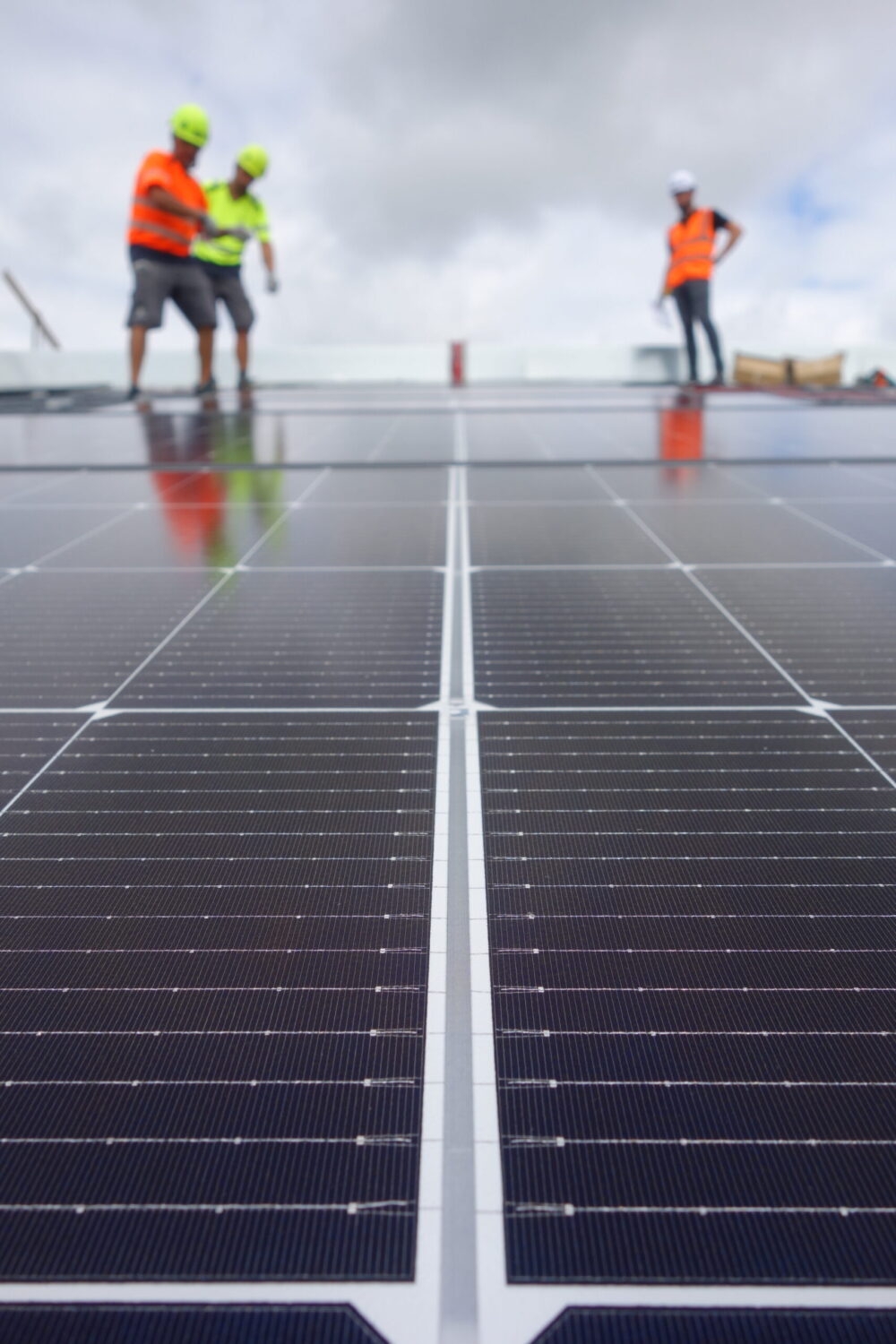
En 2025, Vergnaud a mené : – 160 chantiers, pour 45 MWc installés.
Lire la suite

Depuis 2008, Vergnaud conçoit, installe et assure la durabilité de centaines de centrales photovoltaïques pour les professionnels de la région Nouvelle-Aquitaine.
Basés en Béarn, nous transformons vos surfaces inutilisées en véritables générateurs d’énergie solaire, afin de réduire vos charges et sécuriser vos revenus sur le long terme.
L’histoire de Vergnaud commence grâce à la confiance d’un client sur un chantier de charpente dans le Béarn.
Depuis, nos 50 collaborateurs experts, ont accompagné plusieurs centaines d’entreprises du Sud-Ouest et installé plus de 1000 centrales clé en main, pour faire du solaire un levier stratégique de leurs activités.
Avec plus de 450 clients satisfaits, plus de 1000 centrales solaires, et plus d’1 million de panneaux photovoltaïques posés dans tout le Sud-Ouest et à travers la France, nous savons qu’un solaire bien pensé s’adapte à tous les métiers.
Valorisez durablement votre exploitation en optimisant vos surfaces inexploitées grâce au solaire. Sécurisez vos charges, stabilisez vos coûts, ou créez un revenu supplémentaire: nous vous accompagnons pour un projet 100% sur mesure.
En savoir plusRéduisez vos dépenses énergétiques, renforcez vos engagements, et valorisez vos bâtiments avec des centrales photovoltaïques adaptées à vos contraintes techniques et économiques.
En savoir plusAppuyez-vous sur un partenaire technique fiable, agile et expérimenté pour concevoir, dimensionner et/ou déployer vos projets photovoltaïques, à grande échelle.
En savoir plusAssurez une chantier rentable, dans les temps et dans les budgets impartis, avec un partenaire fiable, reconnu et plébiscité par de nombreux investisseurs de renom.
En savoir plusDe l’étude de faisabilité à maintenance globale, nos équipes 100% internalisées, maîtrisent chaque étape du projet photovoltaïque.
Vous bénéficiez d’un accompagnement complet, d’une conception optimisée et d’une installation pensée pour maximiser votre rentabilité et votre autonomie énergétique.
DécouvrirUne centrale solaire supervisée en continu, et entretenue régulièrement est plus performante sur le long terme.
Avec VergnO&M, nous assurons suivi, maintenance et optimisation de vos installations pour garantir des rendements durables et une sérénité totale.
Augmenter la durabilité de sa centraleNous sommes fiers de participer à rendre l’énergie solaire plus accessible aux professionnels du Sud-Ouest.
Notre sérieux, réactivité et conseil, reconnus et recommandés depuis 2008, nous ont permis de travailler sur des centaines de chantiers variés, complexes, avec toujours, le sens du service et du détail.
dans le photovoltaïque professionnel

centrales solaires installées

de panneaux photovoltaïques posés

produits chaque année

client accompagnés

Echantillons de 50 clients interrogés en 2025

d'euros de chiffre d'affaires

de toitures couverts

Ils nous ont fait confiance, de l'étude à la maintenance


“Pour devenir une entreprise à énergie positive, Vergnaud acteur local nous a accompagnés dès le départ. Pour le technique: ils ont conçu toute l’installation, et se sont occupés de toute la partie administrative, ce qui a été une grande chance vu que nous ne sommes pas spécialistes”
Pierre Couture
Dirigeant, Établissements Couture à Biron (64)
43.614416-0.822894Array
(
    [address] =>
    [lat] => 43.614416
    [lng] => -0.822894
    [zoom] => 14
    [street_number] =>
    [street_name] =>
    [street_short_name] =>
    [city] => POMAREZ
    [state] =>
    [state_short] =>
    [post_code] => 40360
    [country] =>
    [country_short] =>
    [place_id] =>
)
43.215963-0.474972Array
(
    [address] =>
    [lat] => 43.215963
    [lng] => -0.474972
    [zoom] => 14
    [street_number] =>
    [street_name] =>
    [street_short_name] =>
    [city] => LASSEUBE
    [state] =>
    [state_short] =>
    [post_code] => 64290
    [country] =>
    [country_short] =>
    [place_id] =>
)
43.584330-0.320881Array
(
    [address] =>
    [lat] => 43.58433
    [lng] => -0.320881
    [zoom] => 14
    [street_number] =>
    [street_name] =>
    [street_short_name] =>
    [city] => MIRAMONT SENSACQ
    [state] =>
    [state_short] =>
    [post_code] => 40320
    [country] =>
    [country_short] =>
    [place_id] =>
)
43.9110741.561654Array
(
    [address] =>
    [lat] => 43.911074
    [lng] => 1.561654
    [zoom] => 14
    [street_number] =>
    [street_name] =>
    [street_short_name] =>
    [city] => BEAUVAIS SUR TESCOU
    [state] =>
    [state_short] =>
    [post_code] => 81630
    [country] =>
    [country_short] =>
    [place_id] =>
)
43.47355970.2965029856Array
(
    [address] =>
    [lat] => 43.4735597
    [lng] => 0.2965029856
    [zoom] => 14
    [street_number] =>
    [street_name] =>
    [street_short_name] =>
    [city] => LAAS
    [state] =>
    [state_short] =>
    [post_code] => 32170
    [country] =>
    [country_short] =>
    [place_id] =>
)
43.332723-0.047738Array
(
    [address] =>
    [lat] => 43.332723
    [lng] => -0.047738
    [zoom] => 14
    [street_number] =>
    [street_name] =>
    [street_short_name] =>
    [city] => PONSON DEBAT POUTS
    [state] =>
    [state_short] =>
    [post_code] => 64460
    [country] =>
    [country_short] =>
    [place_id] =>
)
43.340664-0.236166Array
(
    [address] =>
    [lat] => 43.340664
    [lng] => -0.236166
    [zoom] => 14
    [street_number] =>
    [street_name] =>
    [street_short_name] =>
    [city] => MORLAAS
    [state] =>
    [state_short] =>
    [post_code] => 64160
    [country] =>
    [country_short] =>
    [place_id] =>
)
43.157062-1.208739Array
(
    [address] =>
    [lat] => 43.157062
    [lng] => -1.208739
    [zoom] => 14
    [street_number] =>
    [street_name] =>
    [street_short_name] =>
    [city] => SAINT JEAN LE VIEUX
    [state] =>
    [state_short] =>
    [post_code] => 64220
    [country] =>
    [country_short] =>
    [place_id] =>
)
44.4256771.079255Array
(
    [address] =>
    [lat] => 44.425677
    [lng] => 1.079255
    [zoom] => 14
    [street_number] =>
    [street_name] =>
    [street_short_name] =>
    [city] => SERIGNAC
    [state] =>
    [state_short] =>
    [post_code] => 46700
    [country] =>
    [country_short] =>
    [place_id] =>
)
43.425969-0.807584Array
(
    [address] =>
    [lat] => 43.425969
    [lng] => -0.807584
    [zoom] => 14
    [street_number] =>
    [street_name] =>
    [street_short_name] =>
    [city] => OZENX MONTESTRUCQ
    [state] =>
    [state_short] =>
    [post_code] => 64300
    [country] =>
    [country_short] =>
    [place_id] =>
)
43.48493-1.16194Array
(
    [address] =>
    [lat] => 43.48493
    [lng] => -1.16194
    [zoom] => 14
    [street_number] =>
    [street_name] =>
    [street_short_name] =>
    [city] => BIDACHE
    [state] =>
    [state_short] =>
    [post_code] => 64520
    [country] =>
    [country_short] =>
    [place_id] =>
)
43.439174-0.415792Array
(
    [address] =>
    [lat] => 43.439174
    [lng] => -0.415792
    [zoom] => 14
    [street_number] =>
    [street_name] =>
    [street_short_name] =>
    [city] => AUBIN
    [state] =>
    [state_short] =>
    [post_code] => 64230
    [country] =>
    [country_short] =>
    [place_id] =>
)
43.4533333333333-0.383055555555556Array
(
    [address] =>
    [lat] => 43.453333333333
    [lng] => -0.38305555555556
    [zoom] => 14
    [street_number] =>
    [street_name] =>
    [street_short_name] =>
    [city] => DOUMY
    [state] =>
    [state_short] =>
    [post_code] => 64450
    [country] =>
    [country_short] =>
    [place_id] =>
)
43.382991990.456918652Array
(
    [address] =>
    [lat] => 43.38299199
    [lng] => 0.456918652
    [zoom] => 14
    [street_number] =>
    [street_name] =>
    [street_short_name] =>
    [city] => SAINT OST
    [state] =>
    [state_short] =>
    [post_code] => 32300
    [country] =>
    [country_short] =>
    [place_id] =>
)
43.373319-0.040098Array
(
    [address] =>
    [lat] => 43.373319
    [lng] => -0.040098
    [zoom] => 14
    [street_number] =>
    [street_name] =>
    [street_short_name] =>
    [city] => LAMAYOU
    [state] =>
    [state_short] =>
    [post_code] => 64460
    [country] =>
    [country_short] =>
    [place_id] =>
)
43.558840-0.622960Array
(
    [address] =>
    [lat] => 43.55884
    [lng] => -0.62296
    [zoom] => 14
    [street_number] =>
    [street_name] =>
    [street_short_name] =>
    [city] => BASSERCLES
    [state] =>
    [state_short] =>
    [post_code] => 40700
    [country] =>
    [country_short] =>
    [place_id] =>
)
43.426028-0.807441Array
(
    [address] =>
    [lat] => 43.426028
    [lng] => -0.807441
    [zoom] => 14
    [street_number] =>
    [street_name] =>
    [street_short_name] =>
    [city] => OZENX MONTESTRUCQ
    [state] =>
    [state_short] =>
    [post_code] => 64300
    [country] =>
    [country_short] =>
    [place_id] =>
)
43.175388-0.196587Array
(
    [address] =>
    [lat] => 43.175388
    [lng] => -0.196587
    [zoom] => 14
    [street_number] =>
    [street_name] =>
    [street_short_name] =>
    [city] => COARRAZE
    [state] =>
    [state_short] =>
    [post_code] => 64800
    [country] =>
    [country_short] =>
    [place_id] =>
)
43.348539-0.38302Array
(
    [address] =>
    [lat] => 43.348539
    [lng] => -0.38302
    [zoom] => 14
    [street_number] =>
    [street_name] =>
    [street_short_name] =>
    [city] => LONS
    [state] =>
    [state_short] =>
    [post_code] => 64140
    [country] =>
    [country_short] =>
    [place_id] =>
)
44.4256771.079255Array
(
    [address] =>
    [lat] => 44.425677
    [lng] => 1.079255
    [zoom] => 14
    [street_number] =>
    [street_name] =>
    [street_short_name] =>
    [city] => SERIGNAC
    [state] =>
    [state_short] =>
    [post_code] => 46700
    [country] =>
    [country_short] =>
    [place_id] =>
)
43.425184-0.844686Array
(
    [address] =>
    [lat] => 43.425184
    [lng] => -0.844686
    [zoom] => 14
    [street_number] =>
    [street_name] =>
    [street_short_name] =>
    [city] => ORION
    [state] =>
    [state_short] =>
    [post_code] => 64390
    [country] =>
    [country_short] =>
    [place_id] =>
)
44.0584130.7444900Array
(
    [address] =>
    [lat] => 44.058413
    [lng] => 0.74449
    [zoom] => 14
    [street_number] =>
    [street_name] =>
    [street_short_name] =>
    [city] => GIMBREDE
    [state] =>
    [state_short] =>
    [post_code] => 32340
    [country] =>
    [country_short] =>
    [place_id] =>
)
43.409720.377069Array
(
    [address] =>
    [lat] => 43.40972
    [lng] => 0.377069
    [zoom] => 14
    [street_number] =>
    [street_name] =>
    [street_short_name] =>
    [city] => SAINTE DODE
    [state] =>
    [state_short] =>
    [post_code] => 32170
    [country] =>
    [country_short] =>
    [place_id] =>
)
43.3374340.2870607Array
(
    [address] =>
    [lat] => 43.337434
    [lng] => 0.2870607
    [zoom] => 14
    [street_number] =>
    [street_name] =>
    [street_short_name] =>
    [city] => ANTIN
    [state] =>
    [state_short] =>
    [post_code] => 65220
    [country] =>
    [country_short] =>
    [place_id] =>
)
43.467044-0.553190Array
(
    [address] =>
    [lat] => 43.467044
    [lng] => -0.55319
    [zoom] => 14
    [street_number] =>
    [street_name] =>
    [street_short_name] =>
    [city] => DOAZON
    [state] =>
    [state_short] =>
    [post_code] => 64370
    [country] =>
    [country_short] =>
    [place_id] =>
)
43.4098060.451413Array
(
    [address] =>
    [lat] => 43.409806
    [lng] => 0.451413
    [zoom] => 14
    [street_number] =>
    [street_name] =>
    [street_short_name] =>
    [city] => SAUVIAC
    [state] =>
    [state_short] =>
    [post_code] => 32300
    [country] =>
    [country_short] =>
    [place_id] =>
)
43.97339-0.0022Array
(
    [address] =>
    [lat] => 43.97339
    [lng] => -0.0022
    [zoom] => 14
    [street_number] =>
    [street_name] =>
    [street_short_name] =>
    [city] => GABARRET
    [state] =>
    [state_short] =>
    [post_code] => 40310
    [country] =>
    [country_short] =>
    [place_id] =>
)
43.501969-1.195999Array
(
    [address] =>
    [lat] => 43.501969
    [lng] => -1.195999
    [zoom] => 14
    [street_number] =>
    [street_name] =>
    [street_short_name] =>
    [city] => GUICHE
    [state] =>
    [state_short] =>
    [post_code] => 64520
    [country] =>
    [country_short] =>
    [place_id] =>
)
43.371530-1.156484Array
(
    [address] =>
    [lat] => 43.37153
    [lng] => -1.156484
    [zoom] => 14
    [street_number] =>
    [street_name] =>
    [street_short_name] =>
    [city] => OREGUE
    [state] =>
    [state_short] =>
    [post_code] => 64120
    [country] =>
    [country_short] =>
    [place_id] =>
)
43.248644-0.774569Array
(
    [address] =>
    [lat] => 43.248644
    [lng] => -0.774569
    [zoom] => 14
    [street_number] =>
    [street_name] =>
    [street_short_name] =>
    [city] => L'HOPITAL SAINT BLAISE
    [state] =>
    [state_short] =>
    [post_code] => 64130
    [country] =>
    [country_short] =>
    [place_id] =>
)
44.4426920.550485Array
(
    [address] =>
    [lat] => 44.442692
    [lng] => 0.550485
    [zoom] => 14
    [street_number] =>
    [street_name] =>
    [street_short_name] =>
    [city] => MONCLAR
    [state] =>
    [state_short] =>
    [post_code] => 47380
    [country] =>
    [country_short] =>
    [place_id] =>
)
43.6695160.6034863Array
(
    [address] =>
    [lat] => 43.669516
    [lng] => 0.6034863
    [zoom] => 14
    [street_number] =>
    [street_name] =>
    [street_short_name] =>
    [city] => AUCH
    [state] =>
    [state_short] =>
    [post_code] => 32000
    [country] =>
    [country_short] =>
    [place_id] =>
)
43.322345-1.213039Array
(
    [address] =>
    [lat] => 43.322345
    [lng] => -1.213039
    [zoom] => 14
    [street_number] =>
    [street_name] =>
    [street_short_name] =>
    [city] => SAINT ESTEBEN
    [state] =>
    [state_short] =>
    [post_code] => 64640
    [country] =>
    [country_short] =>
    [place_id] =>
)
43.438834-0.276924Array
(
    [address] =>
    [lat] => 43.438834
    [lng] => -0.276924
    [zoom] => 14
    [street_number] =>
    [street_name] =>
    [street_short_name] =>
    [city] => SEVIGNACQ
    [state] =>
    [state_short] =>
    [post_code] => 64160
    [country] =>
    [country_short] =>
    [place_id] =>
)
43.3374260.2870339Array
(
    [address] =>
    [lat] => 43.337426
    [lng] => 0.2870339
    [zoom] => 14
    [street_number] =>
    [street_name] =>
    [street_short_name] =>
    [city] => ANTIN
    [state] =>
    [state_short] =>
    [post_code] => 65220
    [country] =>
    [country_short] =>
    [place_id] =>
)
43.6695170.6034594Array
(
    [address] =>
    [lat] => 43.669517
    [lng] => 0.6034594
    [zoom] => 14
    [street_number] =>
    [street_name] =>
    [street_short_name] =>
    [city] => AUCH
    [state] =>
    [state_short] =>
    [post_code] => 32000
    [country] =>
    [country_short] =>
    [place_id] =>
)
43.967564-0.051521Array
(
    [address] =>
    [lat] => 43.967564
    [lng] => -0.051521
    [zoom] => 14
    [street_number] =>
    [street_name] =>
    [street_short_name] =>
    [city] => LAGRANGE
    [state] =>
    [state_short] =>
    [post_code] => 40240
    [country] =>
    [country_short] =>
    [place_id] =>
)
43.290997-0.161397Array
(
    [address] =>
    [lat] => 43.290997
    [lng] => -0.161397
    [zoom] => 14
    [street_number] =>
    [street_name] =>
    [street_short_name] =>
    [city] => LOURENTIES
    [state] =>
    [state_short] =>
    [post_code] => 64420
    [country] =>
    [country_short] =>
    [place_id] =>
)
43.5399980.405701Array
(
    [address] =>
    [lat] => 43.539998
    [lng] => 0.405701
    [zoom] => 14
    [street_number] =>
    [street_name] =>
    [street_short_name] =>
    [city] => ESTIPOUY
    [state] =>
    [state_short] =>
    [post_code] => 32300
    [country] =>
    [country_short] =>
    [place_id] =>
)
43.5616952.204233Array
(
    [address] =>
    [lat] => 43.561695
    [lng] => 2.204233
    [zoom] => 14
    [street_number] =>
    [street_name] =>
    [street_short_name] =>
    [city] => NAVES
    [state] =>
    [state_short] =>
    [post_code] => 81710
    [country] =>
    [country_short] =>
    [place_id] =>
)
43.501969-1.195999Array
(
    [address] =>
    [lat] => 43.501969
    [lng] => -1.195999
    [zoom] => 14
    [street_number] =>
    [street_name] =>
    [street_short_name] =>
    [city] => GUICHE
    [state] =>
    [state_short] =>
    [post_code] => 64520
    [country] =>
    [country_short] =>
    [place_id] =>
)
43.518044-1.189201Array
(
    [address] =>
    [lat] => 43.518044
    [lng] => -1.189201
    [zoom] => 14
    [street_number] =>
    [street_name] =>
    [street_short_name] =>
    [city] => GUICHE
    [state] =>
    [state_short] =>
    [post_code] => 64520
    [country] =>
    [country_short] =>
    [place_id] =>
)
44.5033440.871266Array
(
    [address] =>
    [lat] => 44.503344
    [lng] => 0.871266
    [zoom] => 14
    [street_number] =>
    [street_name] =>
    [street_short_name] =>
    [city] => MONSEGUR
    [state] =>
    [state_short] =>
    [post_code] => 47150
    [country] =>
    [country_short] =>
    [place_id] =>
)
43.512010-0.337568Array
(
    [address] =>
    [lat] => 43.51201
    [lng] => -0.337568
    [zoom] => 14
    [street_number] =>
    [street_name] =>
    [street_short_name] =>
    [city] => GARLEDE MONDEBAT
    [state] =>
    [state_short] =>
    [post_code] => 64450
    [country] =>
    [country_short] =>
    [place_id] =>
)
43.5173820.17788Array
(
    [address] =>
    [lat] => 43.517382
    [lng] => 0.17788
    [zoom] => 14
    [street_number] =>
    [street_name] =>
    [street_short_name] =>
    [city] => MARCIAC
    [state] =>
    [state_short] =>
    [post_code] => 32230
    [country] =>
    [country_short] =>
    [place_id] =>
)
43.5570062.204138Array
(
    [address] =>
    [lat] => 43.557006
    [lng] => 2.204138
    [zoom] => 14
    [street_number] =>
    [street_name] =>
    [street_short_name] =>
    [city] => VIVIERS LES MONTAGNES
    [state] =>
    [state_short] =>
    [post_code] => 81290
    [country] =>
    [country_short] =>
    [place_id] =>
)
43.489691-0.611353Array
(
    [address] =>
    [lat] => 43.489691
    [lng] => -0.611353
    [zoom] => 14
    [street_number] =>
    [street_name] =>
    [street_short_name] =>
    [city] => ARTHEZ DE BEARN
    [state] =>
    [state_short] =>
    [post_code] => 64370
    [country] =>
    [country_short] =>
    [place_id] =>
)
43.7185260.692434Array
(
    [address] =>
    [lat] => 43.718526
    [lng] => 0.692434
    [zoom] => 14
    [street_number] =>
    [street_name] =>
    [street_short_name] =>
    [city] => MONTAUT LES CRENEAUX
    [state] =>
    [state_short] =>
    [post_code] => 32810
    [country] =>
    [country_short] =>
    [place_id] =>
)
43.3843880.368721Array
(
    [address] =>
    [lat] => 43.384388
    [lng] => 0.368721
    [zoom] => 14
    [street_number] =>
    [street_name] =>
    [street_short_name] =>
    [city] => MONT DE MARRAST
    [state] =>
    [state_short] =>
    [post_code] => 32170
    [country] =>
    [country_short] =>
    [place_id] =>
)
43.9828760.779157Array
(
    [address] =>
    [lat] => 43.982876
    [lng] => 0.779157
    [zoom] => 14
    [street_number] =>
    [street_name] =>
    [street_short_name] =>
    [city] => MIRADOUX
    [state] =>
    [state_short] =>
    [post_code] => 32340
    [country] =>
    [country_short] =>
    [place_id] =>
)
43.0792980.192376Array
(
    [address] =>
    [lat] => 43.079298
    [lng] => 0.192376
    [zoom] => 14
    [street_number] =>
    [street_name] =>
    [street_short_name] =>
    [city] => UZER
    [state] =>
    [state_short] =>
    [post_code] => 65200
    [country] =>
    [country_short] =>
    [place_id] =>
)
43.6727220.1246993Array
(
    [address] =>
    [lat] => 43.672722
    [lng] => 0.1246993
    [zoom] => 14
    [street_number] =>
    [street_name] =>
    [street_short_name] =>
    [city] => CASTELNAVET
    [state] =>
    [state_short] =>
    [post_code] => 32290
    [country] =>
    [country_short] =>
    [place_id] =>
)
43.6836670.630444Array
(
    [address] =>
    [lat] => 43.683667
    [lng] => 0.630444
    [zoom] => 14
    [street_number] =>
    [street_name] =>
    [street_short_name] =>
    [city] => MONTAUT LES CRENEAUX
    [state] =>
    [state_short] =>
    [post_code] => 32810
    [country] =>
    [country_short] =>
    [place_id] =>
)
43.3946410.434259Array
(
    [address] =>
    [lat] => 43.394641
    [lng] => 0.434259
    [zoom] => 14
    [street_number] =>
    [street_name] =>
    [street_short_name] =>
    [city] => MONTAUT
    [state] =>
    [state_short] =>
    [post_code] => 32300
    [country] =>
    [country_short] =>
    [place_id] =>
)
43.376137-0.221574Array
(
    [address] =>
    [lat] => 43.376137
    [lng] => -0.221574
    [zoom] => 14
    [street_number] =>
    [street_name] =>
    [street_short_name] =>
    [city] => GABASTON
    [state] =>
    [state_short] =>
    [post_code] => 64160
    [country] =>
    [country_short] =>
    [place_id] =>
)
45.1350554-0.590344Array
(
    [address] =>
    [lat] => 45.1350554
    [lng] => -0.590344
    [zoom] => 14
    [street_number] =>
    [street_name] =>
    [street_short_name] =>
    [city] => CARS
    [state] =>
    [state_short] =>
    [post_code] => 33390
    [country] =>
    [country_short] =>
    [place_id] =>
)
43.316766-0.056603Array
(
    [address] =>
    [lat] => 43.316766
    [lng] => -0.056603
    [zoom] => 14
    [street_number] =>
    [street_name] =>
    [street_short_name] =>
    [city] => PONSON DESSUS
    [state] =>
    [state_short] =>
    [post_code] => 64460
    [country] =>
    [country_short] =>
    [place_id] =>
)
43.4055030.419462Array
(
    [address] =>
    [lat] => 43.405503
    [lng] => 0.419462
    [zoom] => 14
    [street_number] =>
    [street_name] =>
    [street_short_name] =>
    [city] => MONTAUT
    [state] =>
    [state_short] =>
    [post_code] => 32300
    [country] =>
    [country_short] =>
    [place_id] =>
)
43.256504-0.284319Array
(
    [address] =>
    [lat] => 43.256504
    [lng] => -0.284319
    [zoom] => 14
    [street_number] =>
    [street_name] =>
    [street_short_name] =>
    [city] => ASSAT
    [state] =>
    [state_short] =>
    [post_code] => 64510
    [country] =>
    [country_short] =>
    [place_id] =>
)
43.6851920.627386Array
(
    [address] =>
    [lat] => 43.685192
    [lng] => 0.627386
    [zoom] => 14
    [street_number] =>
    [street_name] =>
    [street_short_name] =>
    [city] => MONTAUT LES CRENEAUX
    [state] =>
    [state_short] =>
    [post_code] => 32810
    [country] =>
    [country_short] =>
    [place_id] =>
)
44.8956520.075320Array
(
    [address] =>
    [lat] => 44.895652
    [lng] => 0.07532
    [zoom] => 14
    [street_number] =>
    [street_name] =>
    [street_short_name] =>
    [city] => BONNEVILLE ET ST AVIT DE FUMADIERES
    [state] =>
    [state_short] =>
    [post_code] => 24230
    [country] =>
    [country_short] =>
    [place_id] =>
)
44.6306560.267387Array
(
    [address] =>
    [lat] => 44.630656
    [lng] => 0.267387
    [zoom] => 14
    [street_number] =>
    [street_name] =>
    [street_short_name] =>
    [city] => MONTETON
    [state] =>
    [state_short] =>
    [post_code] => 47120
    [country] =>
    [country_short] =>
    [place_id] =>
)
43.273615-1.215589Array
(
    [address] =>
    [lat] => 43.273615
    [lng] => -1.215589
    [zoom] => 14
    [street_number] =>
    [street_name] =>
    [street_short_name] =>
    [city] => IRISSARRY
    [state] =>
    [state_short] =>
    [post_code] => 64780
    [country] =>
    [country_short] =>
    [place_id] =>
)
43.0719280.629742Array
(
    [address] =>
    [lat] => 43.071928
    [lng] => 0.629742
    [zoom] => 14
    [street_number] =>
    [street_name] =>
    [street_short_name] =>
    [city] => CIER DE RIVIERE
    [state] =>
    [state_short] =>
    [post_code] => 31510
    [country] =>
    [country_short] =>
    [place_id] =>
)
43.685423-0.186593Array
(
    [address] =>
    [lat] => 43.685423
    [lng] => -0.186593
    [zoom] => 14
    [street_number] =>
    [street_name] =>
    [street_short_name] =>
    [city] => Barcelonne du  Gers
    [state] =>
    [state_short] =>
    [post_code] => 32720
    [country] =>
    [country_short] =>
    [place_id] =>
)
43.3983020.203253Array
(
    [address] =>
    [lat] => 43.398302
    [lng] => 0.203253
    [zoom] => 14
    [street_number] =>
    [street_name] =>
    [street_short_name] =>
    [city] => VILLECOMTAL SUR ARROS
    [state] =>
    [state_short] =>
    [post_code] => 32730
    [country] =>
    [country_short] =>
    [place_id] =>
)
43.499396-1.184658Array
(
    [address] =>
    [lat] => 43.499396
    [lng] => -1.184658
    [zoom] => 14
    [street_number] =>
    [street_name] =>
    [street_short_name] =>
    [city] => GUICHE
    [state] =>
    [state_short] =>
    [post_code] => 64520
    [country] =>
    [country_short] =>
    [place_id] =>
)
44.6304330.266895Array
(
    [address] =>
    [lat] => 44.630433
    [lng] => 0.266895
    [zoom] => 14
    [street_number] =>
    [street_name] =>
    [street_short_name] =>
    [city] => MONTETON
    [state] =>
    [state_short] =>
    [post_code] => 47120
    [country] =>
    [country_short] =>
    [place_id] =>
)
43.482558-0.554069Array
(
    [address] =>
    [lat] => 43.482558
    [lng] => -0.554069
    [zoom] => 14
    [street_number] =>
    [street_name] =>
    [street_short_name] =>
    [city] => POMPS
    [state] =>
    [state_short] =>
    [post_code] => 64370
    [country] =>
    [country_short] =>
    [place_id] =>
)
43.567284-0.454348Array
(
    [address] =>
    [lat] => 43.567284
    [lng] => -0.454348
    [zoom] => 14
    [street_number] =>
    [street_name] =>
    [street_short_name] =>
    [city] => MALAUSSANNE
    [state] =>
    [state_short] =>
    [post_code] => 64410
    [country] =>
    [country_short] =>
    [place_id] =>
)
44.6194711.509366Array
(
    [address] =>
    [lat] => 44.619471
    [lng] => 1.509366
    [zoom] => 14
    [street_number] =>
    [street_name] =>
    [street_short_name] =>
    [city] => LAMOTHE CASSEL
    [state] =>
    [state_short] =>
    [post_code] => 46240
    [country] =>
    [country_short] =>
    [place_id] =>
)
43.3362540.944085Array
(
    [address] =>
    [lat] => 43.336254
    [lng] => 0.944085
    [zoom] => 14
    [street_number] =>
    [street_name] =>
    [street_short_name] =>
    [city] => LABASTIDE PAUMES
    [state] =>
    [state_short] =>
    [post_code] => 31230
    [country] =>
    [country_short] =>
    [place_id] =>
)
43.5129960.191969Array
(
    [address] =>
    [lat] => 43.512996
    [lng] => 0.191969
    [zoom] => 14
    [street_number] =>
    [street_name] =>
    [street_short_name] =>
    [city] => MONLEZUN
    [state] =>
    [state_short] =>
    [post_code] => 32230
    [country] =>
    [country_short] =>
    [place_id] =>
)
43.483249-0.740332Array
(
    [address] =>
    [lat] => 43.483249
    [lng] => -0.740332
    [zoom] => 14
    [street_number] =>
    [street_name] =>
    [street_short_name] =>
    [city] => ORTHEZ
    [state] =>
    [state_short] =>
    [post_code] => 64300
    [country] =>
    [country_short] =>
    [place_id] =>
)
43.436914-0.469934Array
(
    [address] =>
    [lat] => 43.436914
    [lng] => -0.469934
    [zoom] => 14
    [street_number] =>
    [street_name] =>
    [street_short_name] =>
    [city] => MAZEROLLES
    [state] =>
    [state_short] =>
    [post_code] => 64230
    [country] =>
    [country_short] =>
    [place_id] =>
)
44.6194711.509366Array
(
    [address] =>
    [lat] => 44.619471
    [lng] => 1.509366
    [zoom] => 14
    [street_number] =>
    [street_name] =>
    [street_short_name] =>
    [city] => LAMOTHE CASSEL
    [state] =>
    [state_short] =>
    [post_code] => 46240
    [country] =>
    [country_short] =>
    [place_id] =>
)
44.453116552.830309423Array
(
    [address] =>
    [lat] => 44
    [lng] => 2
    [zoom] => 14
    [street_number] =>
    [street_name] =>
    [street_short_name] =>
    [city] => GABRIAC
    [state] =>
    [state_short] =>
    [post_code] => 12340
    [country] =>
    [country_short] =>
    [place_id] =>
)
43.11251.11777777777778Array
(
    [address] =>
    [lat] => 43.1125
    [lng] => 1.1177777777778
    [zoom] => 14
    [street_number] =>
    [street_name] =>
    [street_short_name] =>
    [city] => FABAS
    [state] =>
    [state_short] =>
    [post_code] => 09230
    [country] =>
    [country_short] =>
    [place_id] =>
)
47.13694444444441.8375Array
(
    [address] =>
    [lat] => 47.136944444444
    [lng] => 1.8375
    [zoom] => 14
    [street_number] =>
    [street_name] =>
    [street_short_name] =>
    [city] => GRACAY
    [state] =>
    [state_short] =>
    [post_code] => 18310
    [country] =>
    [country_short] =>
    [place_id] =>
)
43.8058333333333-0.808055555555556Array
(
    [address] =>
    [lat] => 43.805833333333
    [lng] => -0.80805555555556
    [zoom] => 14
    [street_number] =>
    [street_name] =>
    [street_short_name] =>
    [city] => AUDON
    [state] =>
    [state_short] =>
    [post_code] => 40400
    [country] =>
    [country_short] =>
    [place_id] =>
)
43.36540277777780.469002777777778Array
(
    [address] =>
    [lat] => 43.365402777778
    [lng] => 0.46900277777778
    [zoom] => 14
    [street_number] =>
    [street_name] =>
    [street_short_name] =>
    [city] => SAINT OST
    [state] =>
    [state_short] =>
    [post_code] => 32300
    [country] =>
    [country_short] =>
    [place_id] =>
)
43.4852777777778-0.746944444444444Array
(
    [address] =>
    [lat] => 43.485277777778
    [lng] => -0.74694444444444
    [zoom] => 14
    [street_number] =>
    [street_name] =>
    [street_short_name] =>
    [city] => ORTHEZ
    [state] =>
    [state_short] =>
    [post_code] => 64300
    [country] =>
    [country_short] =>
    [place_id] =>
)
43.6338888888889-1.08944444444444Array
(
    [address] =>
    [lat] => 43.633888888889
    [lng] => -1.0894444444444
    [zoom] => 14
    [street_number] =>
    [street_name] =>
    [street_short_name] =>
    [city] => HEUGAS
    [state] =>
    [state_short] =>
    [post_code] => 40180
    [country] =>
    [country_short] =>
    [place_id] =>
)
44.453252932.82968452Array
(
    [address] =>
    [lat] => 44
    [lng] => 2
    [zoom] => 14
    [street_number] =>
    [street_name] =>
    [street_short_name] =>
    [city] => GABRIAC
    [state] =>
    [state_short] =>
    [post_code] => 12340
    [country] =>
    [country_short] =>
    [place_id] =>
)
43.68963611111110.824463888888889Array
(
    [address] =>
    [lat] => 43.689636111111
    [lng] => 0.82446388888889
    [zoom] => 14
    [street_number] =>
    [street_name] =>
    [street_short_name] =>
    [city] => SAINT SAUVY
    [state] =>
    [state_short] =>
    [post_code] => 32270
    [country] =>
    [country_short] =>
    [place_id] =>
)
43.46835946-1.222142722Array
(
    [address] =>
    [lat] => 43
    [lng] => -1
    [zoom] => 14
    [street_number] =>
    [street_name] =>
    [street_short_name] =>
    [city] => BARDOS
    [state] =>
    [state_short] =>
    [post_code] => 64520
    [country] =>
    [country_short] =>
    [place_id] =>
)
47.3336111111111-1.5425Array
(
    [address] =>
    [lat] => 47.333611111111
    [lng] => -1.5425
    [zoom] => 14
    [street_number] =>
    [street_name] =>
    [street_short_name] =>
    [city] => SUCE SUR ERDRE
    [state] =>
    [state_short] =>
    [post_code] => 44240
    [country] =>
    [country_short] =>
    [place_id] =>
)
44.21416666666671.43111111111111Array
(
    [address] =>
    [lat] => 44.214166666667
    [lng] => 1.4311111111111
    [zoom] => 14
    [street_number] =>
    [street_name] =>
    [street_short_name] =>
    [city] => MONTPEZAT DE QUERCY
    [state] =>
    [state_short] =>
    [post_code] => 82270
    [country] =>
    [country_short] =>
    [place_id] =>
)
46.46887778-1.060532726Array
(
    [address] =>
    [lat] => 46
    [lng] => -1
    [zoom] => 14
    [street_number] =>
    [street_name] =>
    [street_short_name] =>
    [city] => NALLIERS
    [state] =>
    [state_short] =>
    [post_code] => 85370
    [country] =>
    [country_short] =>
    [place_id] =>
)
43.84083333333330.344444444444444Array
(
    [address] =>
    [lat] => 43.840833333333
    [lng] => 0.34444444444444
    [zoom] => 14
    [street_number] =>
    [street_name] =>
    [street_short_name] =>
    [city] => BEAUCAIRE
    [state] =>
    [state_short] =>
    [post_code] => 32410
    [country] =>
    [country_short] =>
    [place_id] =>
)
44.213601172.014473726Array
(
    [address] =>
    [lat] => 44
    [lng] => 2
    [zoom] => 14
    [street_number] =>
    [street_name] =>
    [street_short_name] =>
    [city] => NAJAC
    [state] =>
    [state_short] =>
    [post_code] => 12270
    [country] =>
    [country_short] =>
    [place_id] =>
)
43.81888888888895.00833333333333Array
(
    [address] =>
    [lat] => 43.818888888889
    [lng] => 5.0083333333333
    [zoom] => 14
    [street_number] =>
    [street_name] =>
    [street_short_name] =>
    [city] => PLAN D'ORGON
    [state] =>
    [state_short] =>
    [post_code] => 13750
    [country] =>
    [country_short] =>
    [place_id] =>
)
44.41916666666671.0075Array
(
    [address] =>
    [lat] => 44.419166666667
    [lng] => 1.0075
    [zoom] => 14
    [street_number] =>
    [street_name] =>
    [street_short_name] =>
    [city] => TOURNON D'AGENAIS
    [state] =>
    [state_short] =>
    [post_code] => 47370
    [country] =>
    [country_short] =>
    [place_id] =>
)
44.669498714.704609264Array
(
    [address] =>
    [lat] => 44
    [lng] => 4
    [zoom] => 14
    [street_number] =>
    [street_name] =>
    [street_short_name] =>
    [city] => ST VINCENT DE BARRES
    [state] =>
    [state_short] =>
    [post_code] => 07210
    [country] =>
    [country_short] =>
    [place_id] =>
)
44.66946114.704964676Array
(
    [address] =>
    [lat] => 44
    [lng] => 4
    [zoom] => 14
    [street_number] =>
    [street_name] =>
    [street_short_name] =>
    [city] => ST VINCENT DE BARRES
    [state] =>
    [state_short] =>
    [post_code] => 07210
    [country] =>
    [country_short] =>
    [place_id] =>
)
44.41972222222221.00861111111111Array
(
    [address] =>
    [lat] => 44.419722222222
    [lng] => 1.0086111111111
    [zoom] => 14
    [street_number] =>
    [street_name] =>
    [street_short_name] =>
    [city] => TOURNON D'AGENAIS
    [state] =>
    [state_short] =>
    [post_code] => 47370
    [country] =>
    [country_short] =>
    [place_id] =>
)
44.41861111111111.00777777777778Array
(
    [address] =>
    [lat] => 44.418611111111
    [lng] => 1.0077777777778
    [zoom] => 14
    [street_number] =>
    [street_name] =>
    [street_short_name] =>
    [city] => TOURNON D'AGENAIS
    [state] =>
    [state_short] =>
    [post_code] => 47370
    [country] =>
    [country_short] =>
    [place_id] =>
)
43.50527778-0.698888888888889Array
(
    [address] =>
    [lat] => 43
    [lng] => -0.69888888888889
    [zoom] => 14
    [street_number] =>
    [street_name] =>
    [street_short_name] =>
    [city] => BALANSUN
    [state] =>
    [state_short] =>
    [post_code] => 64300
    [country] =>
    [country_short] =>
    [place_id] =>
)
42.81805555555561.97111111111111Array
(
    [address] =>
    [lat] => 42.818055555556
    [lng] => 1.9711111111111
    [zoom] => 14
    [street_number] =>
    [street_name] =>
    [street_short_name] =>
    [city] => BELCAIRE
    [state] =>
    [state_short] =>
    [post_code] => 11340
    [country] =>
    [country_short] =>
    [place_id] =>
)
43.2794444444444-0.216111111111111Array
(
    [address] =>
    [lat] => 43.279444444444
    [lng] => -0.21611111111111
    [zoom] => 14
    [street_number] =>
    [street_name] =>
    [street_short_name] =>
    [city] => NOUSTY
    [state] =>
    [state_short] =>
    [post_code] => 64420
    [country] =>
    [country_short] =>
    [place_id] =>
)
43.2505555555556-0.965Array
(
    [address] =>
    [lat] => 43.250555555556
    [lng] => -0.965
    [zoom] => 14
    [street_number] =>
    [street_name] =>
    [street_short_name] =>
    [city] => Ainharp
    [state] =>
    [state_short] =>
    [post_code] => 64130
    [country] =>
    [country_short] =>
    [place_id] =>
)
43.25-0.965277777777778Array
(
    [address] =>
    [lat] => 43.25
    [lng] => -0.96527777777778
    [zoom] => 14
    [street_number] =>
    [street_name] =>
    [street_short_name] =>
    [city] => Ainharp
    [state] =>
    [state_short] =>
    [post_code] => 64131
    [country] =>
    [country_short] =>
    [place_id] =>
)
43.40972222222220.117222222222222Array
(
    [address] =>
    [lat] => 43.409722222222
    [lng] => 0.11722222222222
    [zoom] => 14
    [street_number] =>
    [street_name] =>
    [street_short_name] =>
    [city] => SEGALAS
    [state] =>
    [state_short] =>
    [post_code] => 65140
    [country] =>
    [country_short] =>
    [place_id] =>
)
43.2472222222222-0.911944444444444Array
(
    [address] =>
    [lat] => 43.247222222222
    [lng] => -0.91194444444444
    [zoom] => 14
    [street_number] =>
    [street_name] =>
    [street_short_name] =>
    [city] => VIODOS ABENSE DE BAS
    [state] =>
    [state_short] =>
    [post_code] => 64130
    [country] =>
    [country_short] =>
    [place_id] =>
)
44.139006991.46521205Array
(
    [address] =>
    [lat] => 44
    [lng] => 1
    [zoom] => 14
    [street_number] =>
    [street_name] =>
    [street_short_name] =>
    [city] => REALVILLE
    [state] =>
    [state_short] =>
    [post_code] => 82440
    [country] =>
    [country_short] =>
    [place_id] =>
)
44.140211441.461159007Array
(
    [address] =>
    [lat] => 44
    [lng] => 1
    [zoom] => 14
    [street_number] =>
    [street_name] =>
    [street_short_name] =>
    [city] => REALVILLE
    [state] =>
    [state_short] =>
    [post_code] => 82440
    [country] =>
    [country_short] =>
    [place_id] =>
)
43.468380.572931Array
(
    [address] =>
    [lat] => 43.46838
    [lng] => 0.572931
    [zoom] => 14
    [street_number] =>
    [street_name] =>
    [street_short_name] =>
    [city] => LABARTHE
    [state] =>
    [state_short] =>
    [post_code] => 32260
    [country] =>
    [country_short] =>
    [place_id] =>
)
43.177067-0.254423Array
(
    [address] =>
    [lat] => 43.177067
    [lng] => -0.254423
    [zoom] => 14
    [street_number] =>
    [street_name] =>
    [street_short_name] =>
    [city] => NAY
    [state] =>
    [state_short] =>
    [post_code] => 64800
    [country] =>
    [country_short] =>
    [place_id] =>
)
44.3577930.137734Array
(
    [address] =>
    [lat] => 44.357793
    [lng] => 0.137734
    [zoom] => 14
    [street_number] =>
    [street_name] =>
    [street_short_name] =>
    [city] => SAINTE GEMME MARTAILLAC
    [state] =>
    [state_short] =>
    [post_code] => 47250
    [country] =>
    [country_short] =>
    [place_id] =>
)
43.504443-0.561528Array
(
    [address] =>
    [lat] => 43.504443
    [lng] => -0.561528
    [zoom] => 14
    [street_number] =>
    [street_name] =>
    [street_short_name] =>
    [city] => MORLANNE
    [state] =>
    [state_short] =>
    [post_code] => 64370
    [country] =>
    [country_short] =>
    [place_id] =>
)
43.47583333333330.665277777777778Array
(
    [address] =>
    [lat] => 43.475833333333
    [lng] => 0.66527777777778
    [zoom] => 14
    [street_number] =>
    [street_name] =>
    [street_short_name] =>
    [city] => TACHOIRES
    [state] =>
    [state_short] =>
    [post_code] => 32260
    [country] =>
    [country_short] =>
    [place_id] =>
)
43.481134-0.505082Array
(
    [address] =>
    [lat] => 43.481134
    [lng] => -0.505082
    [zoom] => 14
    [street_number] =>
    [street_name] =>
    [street_short_name] =>
    [city] => UZAN
    [state] =>
    [state_short] =>
    [post_code] => 64370
    [country] =>
    [country_short] =>
    [place_id] =>
)
43.8746830.7169222Array
(
    [address] =>
    [lat] => 43.874683
    [lng] => 0.7169222
    [zoom] => 14
    [street_number] =>
    [street_name] =>
    [street_short_name] =>
    [city] => CASTELNAU D'ARBIEU
    [state] =>
    [state_short] =>
    [post_code] => 32500
    [country] =>
    [country_short] =>
    [place_id] =>
)
44.6953551.311454Array
(
    [address] =>
    [lat] => 44.695355
    [lng] => 1.311454
    [zoom] => 14
    [street_number] =>
    [street_name] =>
    [street_short_name] =>
    [city] => SALVIAC
    [state] =>
    [state_short] =>
    [post_code] => 46340
    [country] =>
    [country_short] =>
    [place_id] =>
)
43.992120.286288Array
(
    [address] =>
    [lat] => 43.99212
    [lng] => 0.286288
    [zoom] => 14
    [street_number] =>
    [street_name] =>
    [street_short_name] =>
    [city] => LARROQUE SUR L'OSSE
    [state] =>
    [state_short] =>
    [post_code] => 32100
    [country] =>
    [country_short] =>
    [place_id] =>
)
43.5440220.407676Array
(
    [address] =>
    [lat] => 43.544022
    [lng] => 0.407676
    [zoom] => 14
    [street_number] =>
    [street_name] =>
    [street_short_name] =>
    [city] => ESTIPOUY
    [state] =>
    [state_short] =>
    [post_code] => 32300
    [country] =>
    [country_short] =>
    [place_id] =>
)
43.369578-0.382660Array
(
    [address] =>
    [lat] => 43.369578
    [lng] => -0.38266
    [zoom] => 14
    [street_number] =>
    [street_name] =>
    [street_short_name] =>
    [city] => SERRES CASTET
    [state] =>
    [state_short] =>
    [post_code] => 64121
    [country] =>
    [country_short] =>
    [place_id] =>
)
43.716121-0.404575Array
(
    [address] =>
    [lat] => 43.716121
    [lng] => -0.404575
    [zoom] => 14
    [street_number] =>
    [street_name] =>
    [street_short_name] =>
    [city] => CLASSUN
    [state] =>
    [state_short] =>
    [post_code] => 40320
    [country] =>
    [country_short] =>
    [place_id] =>
)
43.992120.286288Array
(
    [address] =>
    [lat] => 43.99212
    [lng] => 0.286288
    [zoom] => 14
    [street_number] =>
    [street_name] =>
    [street_short_name] =>
    [city] => LARROQUE SUR L'OSSE
    [state] =>
    [state_short] =>
    [post_code] => 32100
    [country] =>
    [country_short] =>
    [place_id] =>
)
43.9830060.278292Array
(
    [address] =>
    [lat] => 43.983006
    [lng] => 0.278292
    [zoom] => 14
    [street_number] =>
    [street_name] =>
    [street_short_name] =>
    [city] => LARROQUE SUR L OSSE
    [state] =>
    [state_short] =>
    [post_code] => 32100
    [country] =>
    [country_short] =>
    [place_id] =>
)
43.570419-0.402276Array
(
    [address] =>
    [lat] => 43.570419
    [lng] => -0.402276
    [zoom] => 14
    [street_number] =>
    [street_name] =>
    [street_short_name] =>
    [city] => PIMBO
    [state] =>
    [state_short] =>
    [post_code] => 40320
    [country] =>
    [country_short] =>
    [place_id] =>
)
43.3471220.006759Array
(
    [address] =>
    [lat] => 43.347122
    [lng] => 0.006759
    [zoom] => 14
    [street_number] =>
    [street_name] =>
    [street_short_name] =>
    [city] => MONTANER
    [state] =>
    [state_short] =>
    [post_code] => 64460
    [country] =>
    [country_short] =>
    [place_id] =>
)
43.418430-0.093948Array
(
    [address] =>
    [lat] => 43.41843
    [lng] => -0.093948
    [zoom] => 14
    [street_number] =>
    [street_name] =>
    [street_short_name] =>
    [city] => PEYRELONGUE ABOS
    [state] =>
    [state_short] =>
    [post_code] => 64350
    [country] =>
    [country_short] =>
    [place_id] =>
)
43.1507550.115593Array
(
    [address] =>
    [lat] => 43.150755
    [lng] => 0.115593
    [zoom] => 14
    [street_number] =>
    [street_name] =>
    [street_short_name] =>
    [city] => VIELLE-ADOUR
    [state] =>
    [state_short] =>
    [post_code] => 65360
    [country] =>
    [country_short] =>
    [place_id] =>
)
43.6833280.204428Array
(
    [address] =>
    [lat] => 43.683328
    [lng] => 0.204428
    [zoom] => 14
    [street_number] =>
    [street_name] =>
    [street_short_name] =>
    [city] => LUPIAC
    [state] =>
    [state_short] =>
    [post_code] => 32290
    [country] =>
    [country_short] =>
    [place_id] =>
)
43.3389820.158613Array
(
    [address] =>
    [lat] => 43.338982
    [lng] => 0.158613
    [zoom] => 14
    [street_number] =>
    [street_name] =>
    [street_short_name] =>
    [city] => LESCURRY
    [state] =>
    [state_short] =>
    [post_code] => 65140
    [country] =>
    [country_short] =>
    [place_id] =>
)
43.478131-1.056043Array
(
    [address] =>
    [lat] => 43.478131
    [lng] => -1.056043
    [zoom] => 14
    [street_number] =>
    [street_name] =>
    [street_short_name] =>
    [city] => LABASTIDE VILLE-FRANCHE
    [state] =>
    [state_short] =>
    [post_code] => 64270
    [country] =>
    [country_short] =>
    [place_id] =>
)
43.442613-0.696268Array
(
    [address] =>
    [lat] => 43.442613
    [lng] => -0.696268
    [zoom] => 14
    [street_number] =>
    [street_name] =>
    [street_short_name] =>
    [city] => MASLACQ
    [state] =>
    [state_short] =>
    [post_code] => 64300
    [country] =>
    [country_short] =>
    [place_id] =>
)
43.6719530.0115603Array
(
    [address] =>
    [lat] => 43.671953
    [lng] => 0.0115603
    [zoom] => 14
    [street_number] =>
    [street_name] =>
    [street_short_name] =>
    [city] => FUSTEROUAU
    [state] =>
    [state_short] =>
    [post_code] => 32400
    [country] =>
    [country_short] =>
    [place_id] =>
)
43.581176-1.159749Array
(
    [address] =>
    [lat] => 43.581176
    [lng] => -1.159749
    [zoom] => 14
    [street_number] =>
    [street_name] =>
    [street_short_name] =>
    [city] => SAINT ETIENNE D'ORTHE
    [state] =>
    [state_short] =>
    [post_code] => 40300
    [country] =>
    [country_short] =>
    [place_id] =>
)
43.972980.690875Array
(
    [address] =>
    [lat] => 43.97298
    [lng] => 0.690875
    [zoom] => 14
    [street_number] =>
    [street_name] =>
    [street_short_name] =>
    [city] => LECTOURE
    [state] =>
    [state_short] =>
    [post_code] => 32700
    [country] =>
    [country_short] =>
    [place_id] =>
)
43.2384350.743335Array
(
    [address] =>
    [lat] => 43.238435
    [lng] => 0.743335
    [zoom] => 14
    [street_number] =>
    [street_name] =>
    [street_short_name] =>
    [city] => CIADOUX
    [state] =>
    [state_short] =>
    [post_code] => 31350
    [country] =>
    [country_short] =>
    [place_id] =>
)
44.4438170.454598Array
(
    [address] =>
    [lat] => 44.443817
    [lng] => 0.454598
    [zoom] => 14
    [street_number] =>
    [street_name] =>
    [street_short_name] =>
    [city] => BRUGNAC
    [state] =>
    [state_short] =>
    [post_code] => 47260
    [country] =>
    [country_short] =>
    [place_id] =>
)
43.9730420.692347Array
(
    [address] =>
    [lat] => 43.973042
    [lng] => 0.692347
    [zoom] => 14
    [street_number] =>
    [street_name] =>
    [street_short_name] =>
    [city] => LECTOURE
    [state] =>
    [state_short] =>
    [post_code] => 32700
    [country] =>
    [country_short] =>
    [place_id] =>
)
43.7082060.333243Array
(
    [address] =>
    [lat] => 43.708206
    [lng] => 0.333243
    [zoom] => 14
    [street_number] =>
    [street_name] =>
    [street_short_name] =>
    [city] => CAILLAVET
    [state] =>
    [state_short] =>
    [post_code] => 32190
    [country] =>
    [country_short] =>
    [place_id] =>
)
45.035241-0.093502Array
(
    [address] =>
    [lat] => 45.035241
    [lng] => -0.093502
    [zoom] => 14
    [street_number] =>
    [street_name] =>
    [street_short_name] =>
    [city] => COUTRAS
    [state] =>
    [state_short] =>
    [post_code] => 33230
    [country] =>
    [country_short] =>
    [place_id] =>
)
43.4091630.117421Array
(
    [address] =>
    [lat] => 43.409163
    [lng] => 0.117421
    [zoom] => 14
    [street_number] =>
    [street_name] =>
    [street_short_name] =>
    [city] => SEGALAS
    [state] =>
    [state_short] =>
    [post_code] => 65140
    [country] =>
    [country_short] =>
    [place_id] =>
)
43.2623720.061554Array
(
    [address] =>
    [lat] => 43.262372
    [lng] => 0.061554
    [zoom] => 14
    [street_number] =>
    [street_name] =>
    [street_short_name] =>
    [city] => BORDERES SUR L'ECHEZ
    [state] =>
    [state_short] =>
    [post_code] => 65320
    [country] =>
    [country_short] =>
    [place_id] =>
)
43.2837220.3855319Array
(
    [address] =>
    [lat] => 43.283722
    [lng] => 0.3855319
    [zoom] => 14
    [street_number] =>
    [street_name] =>
    [street_short_name] =>
    [city] => PUYDARRIEUX
    [state] =>
    [state_short] =>
    [post_code] => 65220
    [country] =>
    [country_short] =>
    [place_id] =>
)
43.3847840.562033Array
(
    [address] =>
    [lat] => 43.384784
    [lng] => 0.562033
    [zoom] => 14
    [street_number] =>
    [street_name] =>
    [street_short_name] =>
    [city] => PANASSAC
    [state] =>
    [state_short] =>
    [post_code] => 32140
    [country] =>
    [country_short] =>
    [place_id] =>
)
43.5752440.215238Array
(
    [address] =>
    [lat] => 43.575244
    [lng] => 0.215238
    [zoom] => 14
    [street_number] =>
    [street_name] =>
    [street_short_name] =>
    [city] => BASSOUES
    [state] =>
    [state_short] =>
    [post_code] => 32320
    [country] =>
    [country_short] =>
    [place_id] =>
)
43.4091630.117421Array
(
    [address] =>
    [lat] => 43.409163
    [lng] => 0.117421
    [zoom] => 14
    [street_number] =>
    [street_name] =>
    [street_short_name] =>
    [city] => SEGALAS
    [state] =>
    [state_short] =>
    [post_code] => 65140
    [country] =>
    [country_short] =>
    [place_id] =>
)
43.440428-0.262707Array
(
    [address] =>
    [lat] => 43.440428
    [lng] => -0.262707
    [zoom] => 14
    [street_number] =>
    [street_name] =>
    [street_short_name] =>
    [city] => SEVIGNACQ
    [state] =>
    [state_short] =>
    [post_code] => 64160
    [country] =>
    [country_short] =>
    [place_id] =>
)
44.900930.244781Array
(
    [address] =>
    [lat] => 44.90093
    [lng] => 0.244781
    [zoom] => 14
    [street_number] =>
    [street_name] =>
    [street_short_name] =>
    [city] => MONFAUCON
    [state] =>
    [state_short] =>
    [post_code] => 24130
    [country] =>
    [country_short] =>
    [place_id] =>
)
43.431217-0.382222Array
(
    [address] =>
    [lat] => 43.431217
    [lng] => -0.382222
    [zoom] => 14
    [street_number] =>
    [street_name] =>
    [street_short_name] =>
    [city] => BOURNOS
    [state] =>
    [state_short] =>
    [post_code] => 64450
    [country] =>
    [country_short] =>
    [place_id] =>
)
43.3089021.219257Array
(
    [address] =>
    [lat] => 43.308902
    [lng] => 1.219257
    [zoom] => 14
    [street_number] =>
    [street_name] =>
    [street_short_name] =>
    [city] => CARBONNE
    [state] =>
    [state_short] =>
    [post_code] => 31390
    [country] =>
    [country_short] =>
    [place_id] =>
)
43.3539040.199974Array
(
    [address] =>
    [lat] => 43.353904
    [lng] => 0.199974
    [zoom] => 14
    [street_number] =>
    [street_name] =>
    [street_short_name] =>
    [city] => SENAC
    [state] =>
    [state_short] =>
    [post_code] => 65140
    [country] =>
    [country_short] =>
    [place_id] =>
)
43.667397-0.669319Array
(
    [address] =>
    [lat] => 43.667397
    [lng] => -0.669319
    [zoom] => 14
    [street_number] =>
    [street_name] =>
    [street_short_name] =>
    [city] => SAINT CRICQ CHALOSSE
    [state] =>
    [state_short] =>
    [post_code] => 40700
    [country] =>
    [country_short] =>
    [place_id] =>
)
44.491873-0.071862Array
(
    [address] =>
    [lat] => 44.491873
    [lng] => -0.071862
    [zoom] => 14
    [street_number] =>
    [street_name] =>
    [street_short_name] =>
    [city] => AILLAS
    [state] =>
    [state_short] =>
    [post_code] => 33124
    [country] =>
    [country_short] =>
    [place_id] =>
)
43.284818-0.081652Array
(
    [address] =>
    [lat] => 43.284818
    [lng] => -0.081652
    [zoom] => 14
    [street_number] =>
    [street_name] =>
    [street_short_name] =>
    [city] => AAST
    [state] =>
    [state_short] =>
    [post_code] => 64460
    [country] =>
    [country_short] =>
    [place_id] =>
)
43.365689-0.22286Array
(
    [address] =>
    [lat] => 43.365689
    [lng] => -0.22286
    [zoom] => 14
    [street_number] =>
    [street_name] =>
    [street_short_name] =>
    [city] => GABASTON
    [state] =>
    [state_short] =>
    [post_code] => 64160
    [country] =>
    [country_short] =>
    [place_id] =>
)
43.287532-1.565107Array
(
    [address] =>
    [lat] => 43.287532
    [lng] => -1.565107
    [zoom] => 14
    [street_number] =>
    [street_name] =>
    [street_short_name] =>
    [city] => SARE
    [state] =>
    [state_short] =>
    [post_code] => 64310
    [country] =>
    [country_short] =>
    [place_id] =>
)
43.365689-0.22286Array
(
    [address] =>
    [lat] => 43.365689
    [lng] => -0.22286
    [zoom] => 14
    [street_number] =>
    [street_name] =>
    [street_short_name] =>
    [city] => GABASTON
    [state] =>
    [state_short] =>
    [post_code] => 64160
    [country] =>
    [country_short] =>
    [place_id] =>
)
43.7552580.0755433Array
(
    [address] =>
    [lat] => 43.755258
    [lng] => 0.0755433
    [zoom] => 14
    [street_number] =>
    [street_name] =>
    [street_short_name] =>
    [city] => AVERON BERGELLE
    [state] =>
    [state_short] =>
    [post_code] => 32290
    [country] =>
    [country_short] =>
    [place_id] =>
)
43.187275-0.306471Array
(
    [address] =>
    [lat] => 43.187275
    [lng] => -0.306471
    [zoom] => 14
    [street_number] =>
    [street_name] =>
    [street_short_name] =>
    [city] => ARROS DE NAY
    [state] =>
    [state_short] =>
    [post_code] => 64800
    [country] =>
    [country_short] =>
    [place_id] =>
)
43.3678460.551108Array
(
    [address] =>
    [lat] => 43.367846
    [lng] => 0.551108
    [zoom] => 14
    [street_number] =>
    [street_name] =>
    [street_short_name] =>
    [city] => CHELAN
    [state] =>
    [state_short] =>
    [post_code] => 32140
    [country] =>
    [country_short] =>
    [place_id] =>
)
43.481757-0.126448Array
(
    [address] =>
    [lat] => 43.481757
    [lng] => -0.126448
    [zoom] => 14
    [street_number] =>
    [street_name] =>
    [street_short_name] =>
    [city] => CASTILLON
    [state] =>
    [state_short] =>
    [post_code] => 64350
    [country] =>
    [country_short] =>
    [place_id] =>
)
43.514868-1.212703Array
(
    [address] =>
    [lat] => 43.514868
    [lng] => -1.212703
    [zoom] => 14
    [street_number] =>
    [street_name] =>
    [street_short_name] =>
    [city] => GUICHE
    [state] =>
    [state_short] =>
    [post_code] => 64520
    [country] =>
    [country_short] =>
    [place_id] =>
)
43.670697-0.392637Array
(
    [address] =>
    [lat] => 43.670697
    [lng] => -0.392637
    [zoom] => 14
    [street_number] =>
    [street_name] =>
    [street_short_name] =>
    [city] => SAINT LOUBOUER
    [state] =>
    [state_short] =>
    [post_code] => 40320
    [country] =>
    [country_short] =>
    [place_id] =>
)
43.751024-0.449051Array
(
    [address] =>
    [lat] => 43.751024
    [lng] => -0.449051
    [zoom] => 14
    [street_number] =>
    [street_name] =>
    [street_short_name] =>
    [city] => MONTGAILLARD
    [state] =>
    [state_short] =>
    [post_code] => 40500
    [country] =>
    [country_short] =>
    [place_id] =>
)
43.5915920.455676Array
(
    [address] =>
    [lat] => 43.591592
    [lng] => 0.455676
    [zoom] => 14
    [street_number] =>
    [street_name] =>
    [street_short_name] =>
    [city] => BARRAN
    [state] =>
    [state_short] =>
    [post_code] => 32350
    [country] =>
    [country_short] =>
    [place_id] =>
)
44.2144441.4311111Array
(
    [address] =>
    [lat] => 44.214444
    [lng] => 1.4311111
    [zoom] => 14
    [street_number] =>
    [street_name] =>
    [street_short_name] =>
    [city] => MONTPEZAT DE QUERCY
    [state] =>
    [state_short] =>
    [post_code] => 82270
    [country] =>
    [country_short] =>
    [place_id] =>
)
43.0919400.024242Array
(
    [address] =>
    [lat] => 43.09194
    [lng] => 0.024242
    [zoom] => 14
    [street_number] =>
    [street_name] =>
    [street_short_name] =>
    [city] => GEZ-EZ-ANGLES
    [state] =>
    [state_short] =>
    [post_code] => 65100
    [country] =>
    [country_short] =>
    [place_id] =>
)
43.43087-1.27102Array
(
    [address] =>
    [lat] => 43.43087
    [lng] => -1.27102
    [zoom] => 14
    [street_number] =>
    [street_name] =>
    [street_short_name] =>
    [city] => HASPARREN
    [state] =>
    [state_short] =>
    [post_code] => 64240
    [country] =>
    [country_short] =>
    [place_id] =>
)
43.7621350.670311Array
(
    [address] =>
    [lat] => 43.762135
    [lng] => 0.670311
    [zoom] => 14
    [street_number] =>
    [street_name] =>
    [street_short_name] =>
    [city] => GAVARRET SUR AULOUSTE
    [state] =>
    [state_short] =>
    [post_code] => 32390
    [country] =>
    [country_short] =>
    [place_id] =>
)
43.319954-0.057909Array
(
    [address] =>
    [lat] => 43.319954
    [lng] => -0.057909
    [zoom] => 14
    [street_number] =>
    [street_name] =>
    [street_short_name] =>
    [city] => PONSON DESSUS
    [state] =>
    [state_short] =>
    [post_code] => 64460
    [country] =>
    [country_short] =>
    [place_id] =>
)
43.489561-0.796355Array
(
    [address] =>
    [lat] => 43.489561
    [lng] => -0.796355
    [zoom] => 14
    [street_number] =>
    [street_name] =>
    [street_short_name] =>
    [city] => ORTHEZ
    [state] =>
    [state_short] =>
    [post_code] => 64300
    [country] =>
    [country_short] =>
    [place_id] =>
)
43.3343710.293422Array
(
    [address] =>
    [lat] => 43.334371
    [lng] => 0.293422
    [zoom] => 14
    [street_number] =>
    [street_name] =>
    [street_short_name] =>
    [city] => ANTIN
    [state] =>
    [state_short] =>
    [post_code] => 65220
    [country] =>
    [country_short] =>
    [place_id] =>
)
44.390969-0.054764Array
(
    [address] =>
    [lat] => 44.390969
    [lng] => -0.054764
    [zoom] => 14
    [street_number] =>
    [street_name] =>
    [street_short_name] =>
    [city] => GRIGNOLS
    [state] =>
    [state_short] =>
    [post_code] => 33690
    [country] =>
    [country_short] =>
    [place_id] =>
)
43.4966660.963108Array
(
    [address] =>
    [lat] => 43.496666
    [lng] => 0.963108
    [zoom] => 14
    [street_number] =>
    [street_name] =>
    [street_short_name] =>
    [city] => SAMATAN
    [state] =>
    [state_short] =>
    [post_code] => 32130
    [country] =>
    [country_short] =>
    [place_id] =>
)
43.1900220.510017Array
(
    [address] =>
    [lat] => 43.190022
    [lng] => 0.510017
    [zoom] => 14
    [street_number] =>
    [street_name] =>
    [street_short_name] =>
    [city] => ARNÉ
    [state] =>
    [state_short] =>
    [post_code] => 65670
    [country] =>
    [country_short] =>
    [place_id] =>
)
43.3335680.231344Array
(
    [address] =>
    [lat] => 43.333568
    [lng] => 0.231344
    [zoom] => 14
    [street_number] =>
    [street_name] =>
    [street_short_name] =>
    [city] => LAMEAC
    [state] =>
    [state_short] =>
    [post_code] => 65140
    [country] =>
    [country_short] =>
    [place_id] =>
)
43.469409-0.753379Array
(
    [address] =>
    [lat] => 43.469409
    [lng] => -0.753379
    [zoom] => 14
    [street_number] =>
    [street_name] =>
    [street_short_name] =>
    [city] => BIRON
    [state] =>
    [state_short] =>
    [post_code] => 64300
    [country] =>
    [country_short] =>
    [place_id] =>
)
43.3115850.357553Array
(
    [address] =>
    [lat] => 43.311585
    [lng] => 0.357553
    [zoom] => 14
    [street_number] =>
    [street_name] =>
    [street_short_name] =>
    [city] => LALANNE-TRIE
    [state] =>
    [state_short] =>
    [post_code] => 65220
    [country] =>
    [country_short] =>
    [place_id] =>
)
43.8623670.793611Array
(
    [address] =>
    [lat] => 43.862367
    [lng] => 0.793611
    [zoom] => 14
    [street_number] =>
    [street_name] =>
    [street_short_name] =>
    [city] => TOURNECOUPE
    [state] =>
    [state_short] =>
    [post_code] => 32380
    [country] =>
    [country_short] =>
    [place_id] =>
)
44.575980.259465Array
(
    [address] =>
    [lat] => 44.57598
    [lng] => 0.259465
    [zoom] => 14
    [street_number] =>
    [street_name] =>
    [street_short_name] =>
    [city] => LACHAPELLE
    [state] =>
    [state_short] =>
    [post_code] => 47350
    [country] =>
    [country_short] =>
    [place_id] =>
)
43.585406-1.040256Array
(
    [address] =>
    [lat] => 43.585406
    [lng] => -1.040256
    [zoom] => 14
    [street_number] =>
    [street_name] =>
    [street_short_name] =>
    [city] => POUILLON
    [state] =>
    [state_short] =>
    [post_code] => 40350
    [country] =>
    [country_short] =>
    [place_id] =>
)
43.3162790.231633Array
(
    [address] =>
    [lat] => 43.316279
    [lng] => 0.231633
    [zoom] => 14
    [street_number] =>
    [street_name] =>
    [street_short_name] =>
    [city] => TROULEY LABARTHE
    [state] =>
    [state_short] =>
    [post_code] => 65140
    [country] =>
    [country_short] =>
    [place_id] =>
)
43.445804-0.910731Array
(
    [address] =>
    [lat] => 43.445804
    [lng] => -0.910731
    [zoom] => 14
    [street_number] =>
    [street_name] =>
    [street_short_name] =>
    [city] => SALIES DE BEARN
    [state] =>
    [state_short] =>
    [post_code] => 64270
    [country] =>
    [country_short] =>
    [place_id] =>
)
43.23532-0.405447Array
(
    [address] =>
    [lat] => 43.23532
    [lng] => -0.405447
    [zoom] => 14
    [street_number] =>
    [street_name] =>
    [street_short_name] =>
    [city] => GAN
    [state] =>
    [state_short] =>
    [post_code] => 64290
    [country] =>
    [country_short] =>
    [place_id] =>
)
44.0267170.641348Array
(
    [address] =>
    [lat] => 44.026717
    [lng] => 0.641348
    [zoom] => 14
    [street_number] =>
    [street_name] =>
    [street_short_name] =>
    [city] => SEMPESSERRE
    [state] =>
    [state_short] =>
    [post_code] => 32700
    [country] =>
    [country_short] =>
    [place_id] =>
)
43.260289-0.247197Array
(
    [address] =>
    [lat] => 43.260289
    [lng] => -0.247197
    [zoom] => 14
    [street_number] =>
    [street_name] =>
    [street_short_name] =>
    [city] => ARTIGUELOUTAN
    [state] =>
    [state_short] =>
    [post_code] => 64420
    [country] =>
    [country_short] =>
    [place_id] =>
)
43.5643350.486518Array
(
    [address] =>
    [lat] => 43.564335
    [lng] => 0.486518
    [zoom] => 14
    [street_number] =>
    [street_name] =>
    [street_short_name] =>
    [city] => MIRAMONT D'ASTARAC
    [state] =>
    [state_short] =>
    [post_code] => 32300
    [country] =>
    [country_short] =>
    [place_id] =>
)
43.298439-0.146325Array
(
    [address] =>
    [lat] => 43.298439
    [lng] => -0.146325
    [zoom] => 14
    [street_number] =>
    [street_name] =>
    [street_short_name] =>
    [city] => ESLOURENTIES DABAN
    [state] =>
    [state_short] =>
    [post_code] => 64420
    [country] =>
    [country_short] =>
    [place_id] =>
)
44.260701962.838746595Array
(
    [address] =>
    [lat] => 44
    [lng] => 2
    [zoom] => 14
    [street_number] =>
    [street_name] =>
    [street_short_name] =>
    [city] => SEGUR
    [state] =>
    [state_short] =>
    [post_code] => 12290
    [country] =>
    [country_short] =>
    [place_id] =>
)
43.590533-1.144071Array
(
    [address] =>
    [lat] => 43
    [lng] => -1
    [zoom] => 14
    [street_number] =>
    [street_name] =>
    [street_short_name] =>
    [city] => BELUS
    [state] =>
    [state_short] =>
    [post_code] => 40300
    [country] =>
    [country_short] =>
    [place_id] =>
)
43.2186420.034592Array
(
    [address] =>
    [lat] => 43.218642
    [lng] => 0.034592
    [zoom] => 14
    [street_number] =>
    [street_name] =>
    [street_short_name] =>
    [city] => IBOS
    [state] =>
    [state_short] =>
    [post_code] => 65420
    [country] =>
    [country_short] =>
    [place_id] =>
)
43.3333230.293074Array
(
    [address] =>
    [lat] => 43.333323
    [lng] => 0.293074
    [zoom] => 14
    [street_number] =>
    [street_name] =>
    [street_short_name] =>
    [city] => ANTIN
    [state] =>
    [state_short] =>
    [post_code] => 65220
    [country] =>
    [country_short] =>
    [place_id] =>
)
43.3167260.30981Array
(
    [address] =>
    [lat] => 43.316726
    [lng] => 0.30981
    [zoom] => 14
    [street_number] =>
    [street_name] =>
    [street_short_name] =>
    [city] => LUBRET SAINT LUC
    [state] =>
    [state_short] =>
    [post_code] => 65220
    [country] =>
    [country_short] =>
    [place_id] =>
)
43.2363-0.202244Array
(
    [address] =>
    [lat] => 43.2363
    [lng] => -0.202244
    [zoom] => 14
    [street_number] =>
    [street_name] =>
    [street_short_name] =>
    [city] => LUCGARIER
    [state] =>
    [state_short] =>
    [post_code] => 64420
    [country] =>
    [country_short] =>
    [place_id] =>
)
43.370538-0.214244Array
(
    [address] =>
    [lat] => 43.370538
    [lng] => -0.214244
    [zoom] => 14
    [street_number] =>
    [street_name] =>
    [street_short_name] =>
    [city] => GABASTON
    [state] =>
    [state_short] =>
    [post_code] => 64160
    [country] =>
    [country_short] =>
    [place_id] =>
)
43.692701-0.102551Array
(
    [address] =>
    [lat] => 43.692701
    [lng] => -0.102551
    [zoom] => 14
    [street_number] =>
    [street_name] =>
    [street_short_name] =>
    [city] => CAUMONT
    [state] =>
    [state_short] =>
    [post_code] => 32400
    [country] =>
    [country_short] =>
    [place_id] =>
)
43.239694-0.357593Array
(
    [address] =>
    [lat] => 43.239694
    [lng] => -0.357593
    [zoom] => 14
    [street_number] =>
    [street_name] =>
    [street_short_name] =>
    [city] => GELOS
    [state] =>
    [state_short] =>
    [post_code] => 64110
    [country] =>
    [country_short] =>
    [place_id] =>
)
43.124150.449067Array
(
    [address] =>
    [lat] => 43.12415
    [lng] => 0.449067
    [zoom] => 14
    [street_number] =>
    [street_name] =>
    [street_short_name] =>
    [city] => PINAS
    [state] =>
    [state_short] =>
    [post_code] => 65300
    [country] =>
    [country_short] =>
    [place_id] =>
)
43.272222-0.133333Array
(
    [address] =>
    [lat] => 43.272222
    [lng] => -0.133333
    [zoom] => 14
    [street_number] =>
    [street_name] =>
    [street_short_name] =>
    [city] => LUQUET
    [state] =>
    [state_short] =>
    [post_code] => 65320
    [country] =>
    [country_short] =>
    [place_id] =>
)
43.4466941.52827Array
(
    [address] =>
    [lat] => 43.446694
    [lng] => 1.52827
    [zoom] => 14
    [street_number] =>
    [street_name] =>
    [street_short_name] =>
    [city] => MONTBRUN-LAURAGAIS
    [state] =>
    [state_short] =>
    [post_code] => 31450
    [country] =>
    [country_short] =>
    [place_id] =>
)
44.6703530.344136Array
(
    [address] =>
    [lat] => 44.670353
    [lng] => 0.344136
    [zoom] => 14
    [street_number] =>
    [street_name] =>
    [street_short_name] =>
    [city] => SOUMENSAC
    [state] =>
    [state_short] =>
    [post_code] => 47120
    [country] =>
    [country_short] =>
    [place_id] =>
)
43.4027770.2841666Array
(
    [address] =>
    [lat] => 43.402777
    [lng] => 0.2841666
    [zoom] => 14
    [street_number] =>
    [street_name] =>
    [street_short_name] =>
    [city] => ESTAMPES
    [state] =>
    [state_short] =>
    [post_code] => 32170
    [country] =>
    [country_short] =>
    [place_id] =>
)
43.370538-0.214244Array
(
    [address] =>
    [lat] => 43.370538
    [lng] => -0.214244
    [zoom] => 14
    [street_number] =>
    [street_name] =>
    [street_short_name] =>
    [city] => GABASTON
    [state] =>
    [state_short] =>
    [post_code] => 64160
    [country] =>
    [country_short] =>
    [place_id] =>
)
44.9154811.381928Array
(
    [address] =>
    [lat] => 44.915481
    [lng] => 1.381928
    [zoom] => 14
    [street_number] =>
    [street_name] =>
    [street_short_name] =>
    [city] => ORLIAGUET
    [state] =>
    [state_short] =>
    [post_code] => 24370
    [country] =>
    [country_short] =>
    [place_id] =>
)
43.9872223.8930555Array
(
[address] =>
[lat] => 43.987222
[lng] => 3.8930555
[zoom] => 14
[street_number] =>
[street_name] =>
[street_short_name] =>
[city] => MONOBLET
[state] =>
[state_short] =>
[post_code] => 30170
[country] =>
[country_short] =>
[place_id] =>
)
45.9599310.6762213Array
(
[address] =>
[lat] => 45.959931
[lng] => 0.6762213
[zoom] => 14
[street_number] =>
[street_name] =>
[street_short_name] =>
[city] => SAINT MAURICE DES LIONS
[state] =>
[state_short] =>
[post_code] => 16500
[country] =>
[country_short] =>
[place_id] =>
)
43.304893-0.424792Array
(
[address] =>
[lat] => 43.304893
[lng] => -0.424792
[zoom] => 14
[street_number] =>
[street_name] =>
[street_short_name] =>
[city] => LONS
[state] =>
[state_short] =>
[post_code] => 64140
[country] =>
[country_short] =>
[place_id] =>
)
43.9872223.8930555Array
(
[address] =>
[lat] => 43.987222
[lng] => 3.8930555
[zoom] => 14
[street_number] =>
[street_name] =>
[street_short_name] =>
[city] => MONOBLET
[state] =>
[state_short] =>
[post_code] => 30170
[country] =>
[country_short] =>
[place_id] =>
)
43.2766660.2008333Array
(
[address] =>
[lat] => 43.276666
[lng] => 0.2008333
[zoom] => 14
[street_number] =>
[street_name] =>
[street_short_name] =>
[city] => CASTELVIELH
[state] =>
[state_short] =>
[post_code] => 65131
[country] =>
[country_short] =>
[place_id] =>
)
44.089626-0.240853Array
(
[address] =>
[lat] => 44.089626
[lng] => -0.240853
[zoom] => 14
[street_number] =>
[street_name] =>
[street_short_name] =>
[city] => SAINT GOR
[state] =>
[state_short] =>
[post_code] => 40120
[country] =>
[country_short] =>
[place_id] =>
)
43.4473820.58012Array
(
[address] =>
[lat] => 43.447382
[lng] => 0.58012
[zoom] => 14
[street_number] =>
[street_name] =>
[street_short_name] =>
[city] => MASSEUBE
[state] =>
[state_short] =>
[post_code] => 32140
[country] =>
[country_short] =>
[place_id] =>
)
43.3294830.648513Array
(
[address] =>
[lat] => 43.329483
[lng] => 0.648513
[zoom] => 14
[street_number] =>
[street_name] =>
[street_short_name] =>
[city] => LALANNE ARQUE
[state] =>
[state_short] =>
[post_code] => 32140
[country] =>
[country_short] =>
[place_id] =>
)
43.4473820.58012Array
(
[address] =>
[lat] => 43.447382
[lng] => 0.58012
[zoom] => 14
[street_number] =>
[street_name] =>
[street_short_name] =>
[city] => MASSEUBE
[state] =>
[state_short] =>
[post_code] => 32140
[country] =>
[country_short] =>
[place_id] =>
)
43.523774-1.226652Array
(
[address] =>
[lat] => 43.523774
[lng] => -1.226652
[zoom] => 14
[street_number] =>
[street_name] =>
[street_short_name] =>
[city] => GUICHE
[state] =>
[state_short] =>
[post_code] => 64520
[country] =>
[country_short] =>
[place_id] =>
)
43.586944-0.345555Array
(
[address] =>
[lat] => 43.586944
[lng] => -0.345555
[zoom] => 14
[street_number] =>
[street_name] =>
[street_short_name] =>
[city] => MIRAMONT SENSACQ
[state] =>
[state_short] =>
[post_code] => 40320
[country] =>
[country_short] =>
[place_id] =>
)
43.5349680.618227Array
(
[address] =>
[lat] => 43.534968
[lng] => 0.618227
[zoom] => 14
[street_number] =>
[street_name] =>
[street_short_name] =>
[city] => SANSAN
[state] =>
[state_short] =>
[post_code] => 32260
[country] =>
[country_short] =>
[place_id] =>
)
43.5402770.1922222Array
(
[address] =>
[lat] => 43.540277
[lng] => 0.1922222
[zoom] => 14
[street_number] =>
[street_name] =>
[street_short_name] =>
[city] => MARCIAC
[state] =>
[state_short] =>
[post_code] => 32230
[country] =>
[country_short] =>
[place_id] =>
)
43.5155550.1786111Array
(
[address] =>
[lat] => 43.515555
[lng] => 0.1786111
[zoom] => 14
[street_number] =>
[street_name] =>
[street_short_name] =>
[city] => MARCIAC
[state] =>
[state_short] =>
[post_code] => 32230
[country] =>
[country_short] =>
[place_id] =>
)
43.4473820.58012Array
(
[address] =>
[lat] => 43.447382
[lng] => 0.58012
[zoom] => 14
[street_number] =>
[street_name] =>
[street_short_name] =>
[city] => MASSEUBE
[state] =>
[state_short] =>
[post_code] => 32140
[country] =>
[country_short] =>
[place_id] =>
)
43.8563880.8030555Array
(
[address] =>
[lat] => 43.856388
[lng] => 0.8030555
[zoom] => 14
[street_number] =>
[street_name] =>
[street_short_name] =>
[city] => TOURNECOUPE
[state] =>
[state_short] =>
[post_code] => 32380
[country] =>
[country_short] =>
[place_id] =>
)
43.365555-0.221388Array
(
[address] =>
[lat] => 43.365555
[lng] => -0.221388
[zoom] => 14
[street_number] =>
[street_name] =>
[street_short_name] =>
[city] => GABASTON
[state] =>
[state_short] =>
[post_code] => 64160
[country] =>
[country_short] =>
[place_id] =>
)
43.34250.4699475Array
(
[address] =>
[lat] => 43.3425
[lng] => 0.4699475
[zoom] => 14
[street_number] =>
[street_name] =>
[street_short_name] =>
[city] => PONSAN SOUBIRAN
[state] =>
[state_short] =>
[post_code] => 32300
[country] =>
[country_short] =>
[place_id] =>
)
43.8394440.7525Array
(
[address] =>
[lat] => 43.839444
[lng] => 0.7525
[zoom] => 14
[street_number] =>
[street_name] =>
[street_short_name] =>
[city] => CADEILHAN
[state] =>
[state_short] =>
[post_code] => 32380
[country] =>
[country_short] =>
[place_id] =>
)
43.7311160.570919Array
(
[address] =>
[lat] => 43.731116
[lng] => 0.570919
[zoom] => 14
[street_number] =>
[street_name] =>
[street_short_name] =>
[city] => ROQUELAURE
[state] =>
[state_short] =>
[post_code] => 32810
[country] =>
[country_short] =>
[place_id] =>
)
43.8747730.717246Array
(
[address] =>
[lat] => 43.874773
[lng] => 0.717246
[zoom] => 14
[street_number] =>
[street_name] =>
[street_short_name] =>
[city] => CASTELNAU D ARBIEU
[state] =>
[state_short] =>
[post_code] => 32500
[country] =>
[country_short] =>
[place_id] =>
)
43.9127150.62635Array
(
[address] =>
[lat] => 43.912715
[lng] => 0.62635
[zoom] => 14
[street_number] =>
[street_name] =>
[street_short_name] =>
[city] => LECTOURE
[state] =>
[state_short] =>
[post_code] => 32700
[country] =>
[country_short] =>
[place_id] =>
)
43.3802770.5652777Array
(
[address] =>
[lat] => 43.380277
[lng] => 0.5652777
[zoom] => 14
[street_number] =>
[street_name] =>
[street_short_name] =>
[city] => PANASSAC
[state] =>
[state_short] =>
[post_code] => 32140
[country] =>
[country_short] =>
[place_id] =>
)
43.397409-1.160802Array
(
[address] =>
[lat] => 43.397409
[lng] => -1.160802
[zoom] => 14
[street_number] =>
[street_name] =>
[street_short_name] =>
[city] => OREGUE
[state] =>
[state_short] =>
[post_code] => 64120
[country] =>
[country_short] =>
[place_id] =>
)
43.469409-0.753379Array
(
[address] =>
[lat] => 43.469409
[lng] => -0.753379
[zoom] => 14
[street_number] =>
[street_name] =>
[street_short_name] =>
[city] => BIRON
[state] =>
[state_short] =>
[post_code] => 64300
[country] =>
[country_short] =>
[place_id] =>
)
42.9089471.926758Array
(
[address] =>
[lat] => 42.908947
[lng] => 1.926758
[zoom] => 14
[street_number] =>
[street_name] =>
[street_short_name] =>
[city] => BELESTA
[state] =>
[state_short] =>
[post_code] => 09300
[country] =>
[country_short] =>
[place_id] =>
)
43.256944-0.138611Array
(
[address] =>
[lat] => 43.256944
[lng] => -0.138611
[zoom] => 14
[street_number] =>
[street_name] =>
[street_short_name] =>
[city] => ESPOEY
[state] =>
[state_short] =>
[post_code] => 64420
[country] =>
[country_short] =>
[place_id] =>
)
43.8565910.802578Array
(
[address] =>
[lat] => 43.856591
[lng] => 0.802578
[zoom] => 14
[street_number] =>
[street_name] =>
[street_short_name] =>
[city] => TOURNECOUPE
[state] =>
[state_short] =>
[post_code] => 32380
[country] =>
[country_short] =>
[place_id] =>
)
43.1924270.435234Array
(
[address] =>
[lat] => 43.192427
[lng] => 0.435234
[zoom] => 14
[street_number] =>
[street_name] =>
[street_short_name] =>
[city] => RECURT
[state] =>
[state_short] =>
[post_code] => 65330
[country] =>
[country_short] =>
[place_id] =>
)
43.427103-0.821658Array
(
[address] =>
[lat] => 43.427103
[lng] => -0.821658
[zoom] => 14
[street_number] =>
[street_name] =>
[street_short_name] =>
[city] => OZENX-MONTESTRUCQ
[state] =>
[state_short] =>
[post_code] => 64300
[country] =>
[country_short] =>
[place_id] =>
)
43.3052771.2191666Array
(
[address] =>
[lat] => 43.305277
[lng] => 1.2191666
[zoom] => 14
[street_number] =>
[street_name] =>
[street_short_name] =>
[city] => CARBONNE
[state] =>
[state_short] =>
[post_code] => 31390
[country] =>
[country_short] =>
[place_id] =>
)
43.4211110.59Array
(
[address] =>
[lat] => 43.421111
[lng] => 0.59
[zoom] => 14
[street_number] =>
[street_name] =>
[street_short_name] =>
[city] => MASSEUBE
[state] =>
[state_short] =>
[post_code] => 32140
[country] =>
[country_short] =>
[place_id] =>
)
44.5547220.8225Array
(
[address] =>
[lat] => 44.554722
[lng] => 0.8225
[zoom] => 14
[street_number] =>
[street_name] =>
[street_short_name] =>
[city] => PAULHIAC
[state] =>
[state_short] =>
[post_code] => 47150
[country] =>
[country_short] =>
[place_id] =>
)
45.215768131.031245152Array
(
[address] =>
[lat] => 45
[lng] => 1
[zoom] => 14
[street_number] =>
[street_name] =>
[street_short_name] =>
[city] => GABILLOU
[state] =>
[state_short] =>
[post_code] => 24210
[country] =>
[country_short] =>
[place_id] =>
)
43.280911-0.644481Array
(
[address] =>
[lat] => 43.280911
[lng] => -0.644481
[zoom] => 14
[street_number] =>
[street_name] =>
[street_short_name] =>
[city] => SERRES CASTET
[state] =>
[state_short] =>
[post_code] => 64121
[country] =>
[country_short] =>
[place_id] =>
)
43.342572-0.371327Array
(
[address] =>
[lat] => 43.342572
[lng] => -0.371327
[zoom] => 14
[street_number] =>
[street_name] =>
[street_short_name] =>
[city] => PAU
[state] =>
[state_short] =>
[post_code] => 64000
[country] =>
[country_short] =>
[place_id] =>
)
43.84250.4083333Array
(
[address] =>
[lat] => 43.8425
[lng] => 0.4083333
[zoom] => 14
[street_number] =>
[street_name] =>
[street_short_name] =>
[city] => AYGUENTINTE
[state] =>
[state_short] =>
[post_code] => 32410
[country] =>
[country_short] =>
[place_id] =>
)
44.6026150.597549Array
(
[address] =>
[lat] => 44.602615
[lng] => 0.597549
[zoom] => 14
[street_number] =>
[street_name] =>
[street_short_name] =>
[city] => MONTAURIOL
[state] =>
[state_short] =>
[post_code] => 47330
[country] =>
[country_short] =>
[place_id] =>
)
43.196944-0.475555Array
(
[address] =>
[lat] => 43.196944
[lng] => -0.475555
[zoom] => 14
[street_number] =>
[street_name] =>
[street_short_name] =>
[city] => LASSEUBE
[state] =>
[state_short] =>
[post_code] => 64290
[country] =>
[country_short] =>
[place_id] =>
)
43.6591411.050542Array
(
[address] =>
[lat] => 43
[lng] => 1
[zoom] => 14
[street_number] =>
[street_name] =>
[street_short_name] =>
[city] => L'ISLE JOURDAIN
[state] =>
[state_short] =>
[post_code] => 32600
[country] =>
[country_short] =>
[place_id] =>
)
43.60638889-1.027222222Array
(
[address] =>
[lat] => 43
[lng] => -1
[zoom] => 14
[street_number] =>
[street_name] =>
[street_short_name] =>
[city] => GAAS
[state] =>
[state_short] =>
[post_code] => 40350
[country] =>
[country_short] =>
[place_id] =>
)
44.90194190.24483684Array
(
[address] =>
[lat] => 44.9019419
[lng] => 0.24483684
[zoom] => 14
[street_number] =>
[street_name] =>
[street_short_name] =>
[city] => MONFAUCON
[state] =>
[state_short] =>
[post_code] => 24130
[country] =>
[country_short] =>
[place_id] =>
)
43.36686-1.039927 Array
(
[address] =>
[lat] => 43
[lng] => -1.039927
[zoom] => 14
[street_number] =>
[street_name] =>
[street_short_name] =>
[city] => GABAT
[state] =>
[state_short] =>
[post_code] => 64120
[country] =>
[country_short] =>
[place_id] =>
)
44.123971.684296Array
(
[address] =>
[lat] => 44
[lng] => 1
[zoom] => 14
[street_number] =>
[street_name] =>
[street_short_name] =>
[city] => CAZALS
[state] =>
[state_short] =>
[post_code] => 82140
[country] =>
[country_short] =>
[place_id] =>
)
44.431.283888889Array
(
[address] =>
[lat] => 44
[lng] => 1
[zoom] => 14
[street_number] =>
[street_name] =>
[street_short_name] =>
[city] => CAMBAYRAC
[state] =>
[state_short] =>
[post_code] => 46140
[country] =>
[country_short] =>
[place_id] =>
)
43.4783810.049055Array
(
[address] =>
[lat] => 43.478381
[lng] => 0.049055
[zoom] => 14
[street_number] =>
[street_name] =>
[street_short_name] =>
[city] => MAUBOURGUET
[state] =>
[state_short] =>
[post_code] => 65700
[country] =>
[country_short] =>
[place_id] =>
)
43.41694444-1.222777778Array
(
[address] =>
[lat] => 43
[lng] => -1
[zoom] => 14
[street_number] =>
[street_name] =>
[street_short_name] =>
[city] => LA BASTIDE CLAIRENCE
[state] =>
[state_short] =>
[post_code] => 64240
[country] =>
[country_short] =>
[place_id] =>
)
43.5003391.354754Array
(
[address] =>
[lat] => 43
[lng] => 1
[zoom] => 14
[street_number] =>
[street_name] =>
[street_short_name] =>
[city] => ROQUES
[state] =>
[state_short] =>
[post_code] => 31120
[country] =>
[country_short] =>
[place_id] =>
)
43.528888891.209166667Array
(
[address] =>
[lat] => 43
[lng] => 1
[zoom] => 14
[street_number] =>
[street_name] =>
[street_short_name] =>
[city] => CASTELNAU-MAGNOAC
[state] =>
[state_short] =>
[post_code] => 65230
[country] =>
[country_short] =>
[place_id] =>
)
43.211111111.083055556Array
(
[address] =>
[lat] => 43
[lng] => 1
[zoom] => 14
[street_number] =>
[street_name] =>
[street_short_name] =>
[city] => Fonsorbes
[state] =>
[state_short] =>
[post_code] => 31470
[country] =>
[country_short] =>
[place_id] =>
)
43.211111111.0825Array
(
[address] =>
[lat] => 43
[lng] => 1
[zoom] => 14
[street_number] =>
[street_name] =>
[street_short_name] =>
[city] => Cazeres
[state] =>
[state_short] =>
[post_code] => 31220
[country] =>
[country_short] =>
[place_id] =>
)
43.2112951.082663Array
(
[address] =>
[lat] => 43
[lng] => 1
[zoom] => 14
[street_number] =>
[street_name] =>
[street_short_name] =>
[city] => Cazeres
[state] =>
[state_short] =>
[post_code] => 31220
[country] =>
[country_short] =>
[place_id] =>
)
43.36916667-1.033055556Array
(
[address] =>
[lat] => 43
[lng] => -1
[zoom] => 14
[street_number] =>
[street_name] =>
[street_short_name] =>
[city] => Gabat
[state] =>
[state_short] =>
[post_code] => 64120
[country] =>
[country_short] =>
[place_id] =>
)
44.346944441.065555556Array
(
[address] =>
[lat] => 44
[lng] => 1
[zoom] => 14
[street_number] =>
[street_name] =>
[street_short_name] =>
[city] => MONTAIGU-DE-QUERCY
[state] =>
[state_short] =>
[post_code] => 82150
[country] =>
[country_short] =>
[place_id] =>
)
44.349895851.198884261Array
(
[address] =>
[lat] => 44
[lng] => 1
[zoom] => 14
[street_number] =>
[street_name] =>
[street_short_name] =>
[city] => MONTCUQ-EN-QUERCY-BLANC
[state] =>
[state_short] =>
[post_code] => 46800
[country] =>
[country_short] =>
[place_id] =>
)
45.26346381.033501797Array
(
[address] =>
[lat] => 45
[lng] => 1
[zoom] => 14
[street_number] =>
[street_name] =>
[street_short_name] =>
[city] => TOURTOIRAC
[state] =>
[state_short] =>
[post_code] => 24390
[country] =>
[country_short] =>
[place_id] =>
)
43.46742003-1.222267361Array
(
[address] =>
[lat] => 43
[lng] => -1
[zoom] => 14
[street_number] =>
[street_name] =>
[street_short_name] =>
[city] => BARDOS
[state] =>
[state_short] =>
[post_code] => 64520
[country] =>
[country_short] =>
[place_id] =>
)
44.425833331.079444444Array
(
[address] =>
[lat] => 44
[lng] => 1
[zoom] => 14
[street_number] =>
[street_name] =>
[street_short_name] =>
[city] => SERIGNAC
[state] =>
[state_short] =>
[post_code] => 46700
[country] =>
[country_short] =>
[place_id] =>
)
43.202371-1.142093Array
(
[address] =>
[lat] => 43
[lng] => -1
[zoom] => 14
[street_number] =>
[street_name] =>
[street_short_name] =>
[city] => GAMARTHE
[state] =>
[state_short] =>
[post_code] => 64220
[country] =>
[country_short] =>
[place_id] =>
)
43.469061-1.072083Array
(
[address] =>
[lat] => 43
[lng] => -1
[zoom] => 14
[street_number] =>
[street_name] =>
[street_short_name] =>
[city] => CAME
[state] =>
[state_short] =>
[post_code] => 64520
[country] =>
[country_short] =>
[place_id] =>
)
44.425185781.034494173Array
(
[address] =>
[lat] => 44
[lng] => 1
[zoom] => 14
[street_number] =>
[street_name] =>
[street_short_name] =>
[city] => THEZAC
[state] =>
[state_short] =>
[post_code] => 47370
[country] =>
[country_short] =>
[place_id] =>
)
43.744722224.343055556Array
(
[address] =>
[lat] => 43
[lng] => 4
[zoom] => 14
[street_number] =>
[street_name] =>
[street_short_name] =>
[city] => GENERAC
[state] =>
[state_short] =>
[post_code] => 30510
[country] =>
[country_short] =>
[place_id] =>
)
43.37189966-1.156733152Array
(
[address] =>
[lat] => 43
[lng] => -1
[zoom] => 14
[street_number] =>
[street_name] =>
[street_short_name] =>
[city] => OREGUE
[state] =>
[state_short] =>
[post_code] => 64120
[country] =>
[country_short] =>
[place_id] =>
)
44.752777782.961666667Array
(
[address] =>
[lat] => 44
[lng] => 2
[zoom] => 14
[street_number] =>
[street_name] =>
[street_short_name] =>
[city] => LA TRINITAT
[state] =>
[state_short] =>
[post_code] => 15110
[country] =>
[country_short] =>
[place_id] =>
)
43.46833333-1.221944444Array
(
[address] =>
[lat] => 43
[lng] => -1
[zoom] => 14
[street_number] =>
[street_name] =>
[street_short_name] =>
[city] => BARDOS
[state] =>
[state_short] =>
[post_code] => 64520
[country] =>
[country_short] =>
[place_id] =>
)
44.626663492.250982169Array
(
[address] =>
[lat] => 44
[lng] => 2
[zoom] => 14
[street_number] =>
[street_name] =>
[street_short_name] =>
[city] => SAINT PARTHEM
[state] =>
[state_short] =>
[post_code] => 12300
[country] =>
[country_short] =>
[place_id] =>
)
44.139722221.461111111Array
(
[address] =>
[lat] => 44
[lng] => 1
[zoom] => 14
[street_number] =>
[street_name] =>
[street_short_name] =>
[city] => REALVILLE
[state] =>
[state_short] =>
[post_code] => 82440
[country] =>
[country_short] =>
[place_id] =>
)
43.53435811-1.362434204Array
(
[address] =>
[lat] => 43
[lng] => -1
[zoom] => 14
[street_number] =>
[street_name] =>
[street_short_name] =>
[city] => SAINT MARTIN DE SEIGNANX
[state] =>
[state_short] =>
[post_code] => 40390
[country] =>
[country_short] =>
[place_id] =>
)
44.004518312.945015628Array
(
[address] =>
[lat] => 44
[lng] => 2
[zoom] => 14
[street_number] =>
[street_name] =>
[street_short_name] =>
[city] => SAINT ROME DE CERNON
[state] =>
[state_short] =>
[post_code] => 12490
[country] =>
[country_short] =>
[place_id] =>
)
44.626663492.250982169Array
(
[address] =>
[lat] => 44
[lng] => 2
[zoom] => 14
[street_number] =>
[street_name] =>
[street_short_name] =>
[city] => SAINT PARTHEM
[state] =>
[state_short] =>
[post_code] => 12300
[country] =>
[country_short] =>
[place_id] =>
)
44.998333331.264166667Array
(
[address] =>
[lat] => 44
[lng] => 1
[zoom] => 14
[street_number] =>
[street_name] =>
[street_short_name] =>
[city] => SAINT GENIES
[state] =>
[state_short] =>
[post_code] => 24590
[country] =>
[country_short] =>
[place_id] =>
)
43.40721495-1.19096926Array
(
[address] =>
[lat] => 43
[lng] => -1
[zoom] => 14
[street_number] =>
[street_name] =>
[street_short_name] =>
[city] => LABASTIDE CLAIRENCE
[state] =>
[state_short] =>
[post_code] => 64240
[country] =>
[country_short] =>
[place_id] =>
)
43.57-1.412777778Array
(
[address] =>
[lat] => 43
[lng] => -1
[zoom] => 14
[street_number] =>
[street_name] =>
[street_short_name] =>
[city] => SAINT MARTIN DE SEIGNANX
[state] =>
[state_short] =>
[post_code] => 40390
[country] =>
[country_short] =>
[place_id] =>
)
44.998333331.264166667Array
(
[address] =>
[lat] => 44
[lng] => 1
[zoom] => 14
[street_number] =>
[street_name] =>
[street_short_name] =>
[city] => SAINT GENIES
[state] =>
[state_short] =>
[post_code] => 24590
[country] =>
[country_short] =>
[place_id] =>
)
43.40722431-1.192998212Array
(
[address] =>
[lat] => 43
[lng] => -1
[zoom] => 14
[street_number] =>
[street_name] =>
[street_short_name] =>
[city] => LABASTIDE CLAIRENCE
[state] =>
[state_short] =>
[post_code] => 64240
[country] =>
[country_short] =>
[place_id] =>
)
43.57-1.412777778Array
(
[address] =>
[lat] => 43
[lng] => -1
[zoom] => 14
[street_number] =>
[street_name] =>
[street_short_name] =>
[city] => SAINT MARTIN DE SEIGNANX
[state] =>
[state_short] =>
[post_code] => 40390
[country] =>
[country_short] =>
[place_id] =>
)
43.5341497-1.361998531Array
(
[address] =>
[lat] => 43
[lng] => -1
[zoom] => 14
[street_number] =>
[street_name] =>
[street_short_name] =>
[city] => SAINT MARTIN DE SEIGNANX
[state] =>
[state_short] =>
[post_code] => 40390
[country] =>
[country_short] =>
[place_id] =>
)
43.401388892.974166667Array
(
[address] =>
[lat] => 43
[lng] => 2
[zoom] => 14
[street_number] =>
[street_name] =>
[street_short_name] =>
[city] => CEBAZAN
[state] =>
[state_short] =>
[post_code] => 34360
[country] =>
[country_short] =>
[place_id] =>
)
46.48694444-1.1675Array
(
[address] =>
[lat] => 46
[lng] => -1
[zoom] => 14
[street_number] =>
[street_name] =>
[street_short_name] =>
[city] => CORPE
[state] =>
[state_short] =>
[post_code] => 85320
[country] =>
[country_short] =>
[place_id] =>
)
46.48694444-1.1675Array
(
[address] =>
[lat] => 46
[lng] => -1
[zoom] => 14
[street_number] =>
[street_name] =>
[street_short_name] =>
[city] => CORPE
[state] =>
[state_short] =>
[post_code] => 85320
[country] =>
[country_short] =>
[place_id] =>
)
43.890833332.589722222Array
(
[address] =>
[lat] => 43
[lng] => 2
[zoom] => 14
[street_number] =>
[street_name] =>
[street_short_name] =>
[city] => BALAGUIER SUR RANCE
[state] =>
[state_short] =>
[post_code] => 12380
[country] =>
[country_short] =>
[place_id] =>
)
44.131111112.428888889Array
(
[address] =>
[lat] => 44
[lng] => 2
[zoom] => 14
[street_number] =>
[street_name] =>
[street_short_name] =>
[city] => MELJAC
[state] =>
[state_short] =>
[post_code] => 12120
[country] =>
[country_short] =>
[place_id] =>
)
44.213888892.014444444Array
(
[address] =>
[lat] => 44
[lng] => 2
[zoom] => 14
[street_number] =>
[street_name] =>
[street_short_name] =>
[city] => NAJAC
[state] =>
[state_short] =>
[post_code] => 12270
[country] =>
[country_short] =>
[place_id] =>
)
43.60722222-1.137777778Array
(
[address] =>
[lat] => 43
[lng] => -1
[zoom] => 14
[street_number] =>
[street_name] =>
[street_short_name] =>
[city] => SAINT-LON-LES-MINES
[state] =>
[state_short] =>
[post_code] => 40300
[country] =>
[country_short] =>
[place_id] =>
)
43.96752.945555556Array
(
[address] =>
[lat] => 43
[lng] => 2
[zoom] => 14
[street_number] =>
[street_name] =>
[street_short_name] =>
[city] => ROQUEFORT SUR SOULZON
[state] =>
[state_short] =>
[post_code] => 12250
[country] =>
[country_short] =>
[place_id] =>
)
43.96752.945555556Array
(
[address] =>
[lat] => 43
[lng] => 2
[zoom] => 14
[street_number] =>
[street_name] =>
[street_short_name] =>
[city] => ROQUEFORT SUR SOULZON
[state] =>
[state_short] =>
[post_code] => 12250
[country] =>
[country_short] =>
[place_id] =>
)
43.660442-1.042364Array
(
[address] =>
[lat] => 43
[lng] => -1
[zoom] => 14
[street_number] =>
[street_name] =>
[street_short_name] =>
[city] => SAINT-PANDELON
[state] =>
[state_short] =>
[post_code] => 40180
[country] =>
[country_short] =>
[place_id] =>
)
44.214166671.431111111Array
(
[address] =>
[lat] => 44
[lng] => 1
[zoom] => 14
[street_number] =>
[street_name] =>
[street_short_name] =>
[city] => MONTPEZAT DE QUERCY
[state] =>
[state_short] =>
[post_code] => 82270
[country] =>
[country_short] =>
[place_id] =>
)
47.030833331.547222222Array
(
[address] =>
[lat] => 47
[lng] => 1
[zoom] => 14
[street_number] =>
[street_name] =>
[street_short_name] =>
[city] => MOULINS SUR CEPHONS
[state] =>
[state_short] =>
[post_code] => 36110
[country] =>
[country_short] =>
[place_id] =>
)
45.063333335.023333333Array
(
[address] =>
[lat] => 45
[lng] => 5
[zoom] => 14
[street_number] =>
[street_name] =>
[street_short_name] =>
[city] => ROMANS SUR ISERE
[state] =>
[state_short] =>
[post_code] => 26100
[country] =>
[country_short] =>
[place_id] =>
)
44.2929954.474358Array
(
[address] =>
[lat] => 44
[lng] => 4
[zoom] => 14
[street_number] =>
[street_name] =>
[street_short_name] =>
[city] => LE GARN
[state] =>
[state_short] =>
[post_code] => 30760
[country] =>
[country_short] =>
[place_id] =>
)
44.354444441.9475Array
(
[address] =>
[lat] => 44
[lng] => 1
[zoom] => 14
[street_number] =>
[street_name] =>
[street_short_name] =>
[city] => SAVIGNAC
[state] =>
[state_short] =>
[post_code] => 12200
[country] =>
[country_short] =>
[place_id] =>
)
44.356420524.903921232Array
(
[address] =>
[lat] => 44
[lng] => 4
[zoom] => 14
[street_number] =>
[street_name] =>
[street_short_name] =>
[city] => RICHERENCHES
[state] =>
[state_short] =>
[post_code] => 84600
[country] =>
[country_short] =>
[place_id] =>
)
43.211111111.082777778Array
(
[address] =>
[lat] => 43
[lng] => 1
[zoom] => 14
[street_number] =>
[street_name] =>
[street_short_name] =>
[city] => CAZERES
[state] =>
[state_short] =>
[post_code] => 31220
[country] =>
[country_short] =>
[place_id] =>
)
44.07944.960389Array
(
[address] =>
[lat] => 44
[lng] => 4
[zoom] => 14
[street_number] =>
[street_name] =>
[street_short_name] =>
[city] => SARRIANS
[state] =>
[state_short] =>
[post_code] => 84260
[country] =>
[country_short] =>
[place_id] =>
)
44.745536022.52827249Array
(
[address] =>
[lat] => 44
[lng] => 2
[zoom] => 14
[street_number] =>
[street_name] =>
[street_short_name] =>
[city] => LADINHAC
[state] =>
[state_short] =>
[post_code] => 15120
[country] =>
[country_short] =>
[place_id] =>
)
44.6358294.821097Array
(
[address] =>
[lat] => 44
[lng] => 4
[zoom] => 14
[street_number] =>
[street_name] =>
[street_short_name] =>
[city] => CONDILLAC
[state] =>
[state_short] =>
[post_code] => 26740
[country] =>
[country_short] =>
[place_id] =>
)
46.4876473.632806Array
(
[address] =>
[lat] => 46
[lng] => 3
[zoom] => 14
[street_number] =>
[street_name] =>
[street_short_name] =>
[city] => SAINT POURCAIN SUR BESBRE
[state] =>
[state_short] =>
[post_code] => 03290
[country] =>
[country_short] =>
[place_id] =>
)
46.802203695.020511112Array
(
[address] =>
[lat] => 46
[lng] => 5
[zoom] => 14
[street_number] =>
[street_name] =>
[street_short_name] =>
[city] => SAINT MARTIN EN BRESSE
[state] =>
[state_short] =>
[post_code] => 71620
[country] =>
[country_short] =>
[place_id] =>
)
46.534322772.83037998Array
(
[address] =>
[lat] => 46
[lng] => 2
[zoom] => 14
[street_number] =>
[street_name] =>
[street_short_name] =>
[city] => LOUROUX-BOURBONNAIS
[state] =>
[state_short] =>
[post_code] => 03350
[country] =>
[country_short] =>
[place_id] =>
)
43.210555561.083333333Array
(
[address] =>
[lat] => 43
[lng] => 1
[zoom] => 14
[street_number] =>
[street_name] =>
[street_short_name] =>
[city] => CAZERES
[state] =>
[state_short] =>
[post_code] => 31220
[country] =>
[country_short] =>
[place_id] =>
)
44.7454722.527855Array
(
[address] =>
[lat] => 44
[lng] => 2
[zoom] => 14
[street_number] =>
[street_name] =>
[street_short_name] =>
[city] => LADINHAC
[state] =>
[state_short] =>
[post_code] => 15120
[country] =>
[country_short] =>
[place_id] =>
)
46.8144134.495652Array
(
[address] =>
[lat] => 46
[lng] => 4
[zoom] => 14
[street_number] =>
[street_name] =>
[street_short_name] =>
[city] => SAINT PIERRE DE VARENNES
[state] =>
[state_short] =>
[post_code] => 71670
[country] =>
[country_short] =>
[place_id] =>
)
46.81458334.494935605Array
(
[address] =>
[lat] => 46
[lng] => 4
[zoom] => 14
[street_number] =>
[street_name] =>
[street_short_name] =>
[city] => SAINT PIERRE DE VARENNES
[state] =>
[state_short] =>
[post_code] => 71670
[country] =>
[country_short] =>
[place_id] =>
)
46.802123695.021202832Array
(
[address] =>
[lat] => 46
[lng] => 5
[zoom] => 14
[street_number] =>
[street_name] =>
[street_short_name] =>
[city] => SAINT MARTIN EN BRESSE
[state] =>
[state_short] =>
[post_code] => 71620
[country] =>
[country_short] =>
[place_id] =>
)
46.53577122.83107515Array
(
[address] =>
[lat] => 46
[lng] => 2
[zoom] => 14
[street_number] =>
[street_name] =>
[street_short_name] =>
[city] => LOUROUX-BOURBONNAIS
[state] =>
[state_short] =>
[post_code] => 03350
[country] =>
[country_short] =>
[place_id] =>
)
46.297813.9935Array
(
[address] =>
[lat] => 46
[lng] => 3
[zoom] => 14
[street_number] =>
[street_name] =>
[street_short_name] =>
[city] => CHAMBILLY
[state] =>
[state_short] =>
[post_code] => 71110
[country] =>
[country_short] =>
[place_id] =>
)
47.314304-1.402822Array
(
[address] =>
[lat] => 47
[lng] => -1
[zoom] => 14
[street_number] =>
[street_name] =>
[street_short_name] =>
[city] => MAUVES SUR LOIRE
[state] =>
[state_short] =>
[post_code] => 44470
[country] =>
[country_short] =>
[place_id] =>
)
46.534036222.83038623Array
(
[address] =>
[lat] => 46
[lng] => 2
[zoom] => 14
[street_number] =>
[street_name] =>
[street_short_name] =>
[city] => LOUROUX-BOURBONNAIS
[state] =>
[state_short] =>
[post_code] => 03350
[country] =>
[country_short] =>
[place_id] =>
)
46.4731762.424363Array
(
[address] =>
[lat] => 46
[lng] => 2
[zoom] => 14
[street_number] =>
[street_name] =>
[street_short_name] =>
[city] => COURCAIS
[state] =>
[state_short] =>
[post_code] => 03370
[country] =>
[country_short] =>
[place_id] =>
)
46.4731882.42464938Array
(
[address] =>
[lat] => 46
[lng] => 2
[zoom] => 14
[street_number] =>
[street_name] =>
[street_short_name] =>
[city] => COURCAIS
[state] =>
[state_short] =>
[post_code] => 03370
[country] =>
[country_short] =>
[place_id] =>
)
47.46195502-1.21578836Array
(
[address] =>
[lat] => 47
[lng] => -1
[zoom] => 14
[street_number] =>
[street_name] =>
[street_short_name] =>
[city] => MESANGER
[state] =>
[state_short] =>
[post_code] => 44522
[country] =>
[country_short] =>
[place_id] =>
)
44.6965112.491246Array
(
[address] =>
[lat] => 44
[lng] => 2
[zoom] => 14
[street_number] =>
[street_name] =>
[street_short_name] =>
[city] => MONTSALVY
[state] =>
[state_short] =>
[post_code] => 15120
[country] =>
[country_short] =>
[place_id] =>
)
44.3560924.904045958Array
(
[address] =>
[lat] => 44
[lng] => 4
[zoom] => 14
[street_number] =>
[street_name] =>
[street_short_name] =>
[city] => RICHERENCHES
[state] =>
[state_short] =>
[post_code] => 84600
[country] =>
[country_short] =>
[place_id] =>
)
42.6139312.816431Array
(
[address] =>
[lat] => 42
[lng] => 2
[zoom] => 14
[street_number] =>
[street_name] =>
[street_short_name] =>
[city] => TROUILLAS
[state] =>
[state_short] =>
[post_code] => 66300
[country] =>
[country_short] =>
[place_id] =>
)
46.0084641.758949Array
(
[address] =>
[lat] => 46
[lng] => 1
[zoom] => 14
[street_number] =>
[street_name] =>
[street_short_name] =>
[city] => BOSMOREAU LES MINES
[state] =>
[state_short] =>
[post_code] => 23400
[country] =>
[country_short] =>
[place_id] =>
)
43.286944442.104722222Array
(
[address] =>
[lat] => 43
[lng] => 2
[zoom] => 14
[street_number] =>
[street_name] =>
[street_short_name] =>
[city] => Villepinte
[state] =>
[state_short] =>
[post_code] => 11150
[country] =>
[country_short] =>
[place_id] =>
)
46.3610012.347303Array
(
[address] =>
[lat] => 46
[lng] => 2
[zoom] => 14
[street_number] =>
[street_name] =>
[street_short_name] =>
[city] => TREIGNAT
[state] =>
[state_short] =>
[post_code] => 03380
[country] =>
[country_short] =>
[place_id] =>
)
18.09435-63.04077Array
(
[address] =>
[lat] => 18
[lng] => -63
[zoom] => 14
[street_number] =>
[street_name] =>
[street_short_name] =>
[city] => GRAND CASE
[state] =>
[state_short] =>
[post_code] => 97150
[country] =>
[country_short] =>
[place_id] =>
)
18.09594-63.03774Array
(
[address] =>
[lat] => 18
[lng] => -63
[zoom] => 14
[street_number] =>
[street_name] =>
[street_short_name] =>
[city] => GRAND CASE
[state] =>
[state_short] =>
[post_code] => 97150
[country] =>
[country_short] =>
[place_id] =>
)
18.09606-63.04141Array
(
[address] =>
[lat] => 18
[lng] => -63
[zoom] => 14
[street_number] =>
[street_name] =>
[street_short_name] =>
[city] => GRAND CASE
[state] =>
[state_short] =>
[post_code] => 97150
[country] =>
[country_short] =>
[place_id] =>
)
18.09608-63.045Array
(
[address] =>
[lat] => 18
[lng] => -63
[zoom] => 14
[street_number] =>
[street_name] =>
[street_short_name] =>
[city] => GRAND CASE
[state] =>
[state_short] =>
[post_code] => 97150
[country] =>
[country_short] =>
[place_id] =>
)
46.78676393.39853403Array
(
[address] =>
[lat] => 46
[lng] => 3
[zoom] => 14
[street_number] =>
[street_name] =>
[street_short_name] =>
[city] => SAINT GERMAIN CHASSENAY
[state] =>
[state_short] =>
[post_code] => 58300
[country] =>
[country_short] =>
[place_id] =>
)
18.09425-63.04091Array
(
[address] =>
[lat] => 18
[lng] => -63
[zoom] => 14
[street_number] =>
[street_name] =>
[street_short_name] =>
[city] => GRAND CASE
[state] =>
[state_short] =>
[post_code] => 97150
[country] =>
[country_short] =>
[place_id] =>
)
43.93168592.153256298Array
(
[address] =>
[lat] => 43
[lng] => 2
[zoom] => 14
[street_number] =>
[street_name] =>
[street_short_name] =>
[city] => ALBI
[state] =>
[state_short] =>
[post_code] => 81000
[country] =>
[country_short] =>
[place_id] =>
)
44.0496022.142257097Array
(
[address] =>
[lat] => 44
[lng] => 2
[zoom] => 14
[street_number] =>
[street_name] =>
[street_short_name] =>
[city] => Saint-Benoît-de-Carmaux
[state] =>
[state_short] =>
[post_code] => 81400
[country] =>
[country_short] =>
[place_id] =>
)
18.09612-63.03854Array
(
[address] =>
[lat] => 18
[lng] => -63
[zoom] => 14
[street_number] =>
[street_name] =>
[street_short_name] =>
[city] => GRAND CASE
[state] =>
[state_short] =>
[post_code] => 97150
[country] =>
[country_short] =>
[place_id] =>
)
44.3564724.903968Array
(
[address] =>
[lat] => 44
[lng] => 4
[zoom] => 14
[street_number] =>
[street_name] =>
[street_short_name] =>
[city] => RICHERENCHES
[state] =>
[state_short] =>
[post_code] => 84600
[country] =>
[country_short] =>
[place_id] =>
)
44.07944.960389Array
(
[address] =>
[lat] => 44
[lng] => 4
[zoom] => 14
[street_number] =>
[street_name] =>
[street_short_name] =>
[city] => SARRIANS
[state] =>
[state_short] =>
[post_code] => 84260
[country] =>
[country_short] =>
[place_id] =>
)
43.211111111.082777778Array
(
[address] =>
[lat] => 43
[lng] => 1
[zoom] => 14
[street_number] =>
[street_name] =>
[street_short_name] =>
[city] => CAZERES
[state] =>
[state_short] =>
[post_code] => 31220
[country] =>
[country_short] =>
[place_id] =>
)
43.740159-1.024569Array
(
[address] =>
[lat] => 43
[lng] => -1
[zoom] => 14
[street_number] =>
[street_name] =>
[street_short_name] =>
[city] => ST PAUL LES DAX
[state] =>
[state_short] =>
[post_code] => 40990
[country] =>
[country_short] =>
[place_id] =>
)
45.8142912.825047Array
(
[address] =>
[lat] => 45
[lng] => 2
[zoom] => 14
[street_number] =>
[street_name] =>
[street_short_name] =>
[city] => BROMONT LAMOTHE
[state] =>
[state_short] =>
[post_code] => 63230
[country] =>
[country_short] =>
[place_id] =>
)
44.446111112.225555556Array
(
[address] =>
[lat] => 44
[lng] => 2
[zoom] => 14
[street_number] =>
[street_name] =>
[street_short_name] =>
[city] => ROUSSENAC
[state] =>
[state_short] =>
[post_code] => 12220
[country] =>
[country_short] =>
[place_id] =>
)
43.46777778-1.223055556Array
(
[address] =>
[lat] => 43
[lng] => -1
[zoom] => 14
[street_number] =>
[street_name] =>
[street_short_name] =>
[city] => BARDOS
[state] =>
[state_short] =>
[post_code] => 64520
[country] =>
[country_short] =>
[place_id] =>
)
45.025852321.905409005Array
(
[address] =>
[lat] => 45
[lng] => 1
[zoom] => 14
[street_number] =>
[street_name] =>
[street_short_name] =>
[city] => REYGADE
[state] =>
[state_short] =>
[post_code] => 19430
[country] =>
[country_short] =>
[place_id] =>
)
43.34194444-1.148333333Array
(
[address] =>
[lat] => 43
[lng] => -1
[zoom] => 14
[street_number] =>
[street_name] =>
[street_short_name] =>
[city] => MEHARIN
[state] =>
[state_short] =>
[post_code] => 64120
[country] =>
[country_short] =>
[place_id] =>
)
46.393055563.8275Array
(
[address] =>
[lat] => 46
[lng] => 3
[zoom] => 14
[street_number] =>
[street_name] =>
[street_short_name] =>
[city] => SAINT DIDIER EN DONJON
[state] =>
[state_short] =>
[post_code] => 03130
[country] =>
[country_short] =>
[place_id] =>
)
46.393055563.8275Array
(
[address] =>
[lat] => 46
[lng] => 3
[zoom] => 14
[street_number] =>
[street_name] =>
[street_short_name] =>
[city] => SAINT DIDIER EN DONJON
[state] =>
[state_short] =>
[post_code] => 03130
[country] =>
[country_short] =>
[place_id] =>
)
43.844321734.784481608Array
(
[address] =>
[lat] => 43
[lng] => 4
[zoom] => 14
[street_number] =>
[street_name] =>
[street_short_name] =>
[city] => GRAVESON
[state] =>
[state_short] =>
[post_code] => 16690
[country] =>
[country_short] =>
[place_id] =>
)
43.51555556-1.220555556Array
(
[address] =>
[lat] => 43
[lng] => -1
[zoom] => 14
[street_number] =>
[street_name] =>
[street_short_name] =>
[city] => GUICHE
[state] =>
[state_short] =>
[post_code] => 64520
[country] =>
[country_short] =>
[place_id] =>
)
44.410277783.1175Array
(
[address] =>
[lat] => 44
[lng] => 3
[zoom] => 14
[street_number] =>
[street_name] =>
[street_short_name] =>
[city] => CAMPAGNAC
[state] =>
[state_short] =>
[post_code] => 12560
[country] =>
[country_short] =>
[place_id] =>
)
43.6591191.052711Array
(
[address] =>
[lat] => 43
[lng] => 1
[zoom] => 14
[street_number] =>
[street_name] =>
[street_short_name] =>
[city] => LISLE JOURDAIN
[state] =>
[state_short] =>
[post_code] => 32600
[country] =>
[country_short] =>
[place_id] =>
)
44.410277783.1175Array
(
[address] =>
[lat] => 44
[lng] => 3
[zoom] => 14
[street_number] =>
[street_name] =>
[street_short_name] =>
[city] => CAMPAGNAC
[state] =>
[state_short] =>
[post_code] => 12560
[country] =>
[country_short] =>
[place_id] =>
)
43.240277781.082777778Array
(
[address] =>
[lat] => 43
[lng] => 1
[zoom] => 14
[street_number] =>
[street_name] =>
[street_short_name] =>
[city] => CAZERES
[state] =>
[state_short] =>
[post_code] => 31220
[country] =>
[country_short] =>
[place_id] =>
)
43.887777783.1225Array
(
[address] =>
[lat] => 43
[lng] => 3
[zoom] => 14
[street_number] =>
[street_name] =>
[street_short_name] =>
[city] => FONDAMENTE
[state] =>
[state_short] =>
[post_code] => 12540
[country] =>
[country_short] =>
[place_id] =>
)
44.133888891.600833333Array
(
[address] =>
[lat] => 44
[lng] => 1
[zoom] => 14
[street_number] =>
[street_name] =>
[street_short_name] =>
[city] => SAINT-CIRQ
[state] =>
[state_short] =>
[post_code] => 82300
[country] =>
[country_short] =>
[place_id] =>
)
43.402222225.889444444Array
(
[address] =>
[lat] => 43
[lng] => 5
[zoom] => 14
[street_number] =>
[street_name] =>
[street_short_name] =>
[city] => TOURVES
[state] =>
[state_short] =>
[post_code] => 83170
[country] =>
[country_short] =>
[place_id] =>
)
44.431388892.196944444Array
(
[address] =>
[lat] => 44
[lng] => 2
[zoom] => 14
[street_number] =>
[street_name] =>
[street_short_name] =>
[city] => PRIVEZAC
[state] =>
[state_short] =>
[post_code] => 12350
[country] =>
[country_short] =>
[place_id] =>
)
44.291944442.688611111Array
(
[address] =>
[lat] => 44
[lng] => 2
[zoom] => 14
[street_number] =>
[street_name] =>
[street_short_name] =>
[city] => PONT DE SALARS
[state] =>
[state_short] =>
[post_code] => 12290
[country] =>
[country_short] =>
[place_id] =>
)
44.4266212.081789Array
(
[address] =>
[lat] => 44
[lng] => 2
[zoom] => 14
[street_number] =>
[street_name] =>
[street_short_name] =>
[city] => Villeneuve
[state] =>
[state_short] =>
[post_code] => 12260
[country] =>
[country_short] =>
[place_id] =>
)
44.4152.8225Array
(
[address] =>
[lat] => 44
[lng] => 2
[zoom] => 14
[street_number] =>
[street_name] =>
[street_short_name] =>
[city] => PALMA D'AVEYRON
[state] =>
[state_short] =>
[post_code] => 12310
[country] =>
[country_short] =>
[place_id] =>
)
45.568055561.759444444Array
(
[address] =>
[lat] => 45
[lng] => 1
[zoom] => 14
[street_number] =>
[street_name] =>
[street_short_name] =>
[city] => TREIGNAC
[state] =>
[state_short] =>
[post_code] => 19260
[country] =>
[country_short] =>
[place_id] =>
)
45.56751.761944444Array
(
[address] =>
[lat] => 45
[lng] => 1
[zoom] => 14
[street_number] =>
[street_name] =>
[street_short_name] =>
[city] => TREIGNAC
[state] =>
[state_short] =>
[post_code] => 19260
[country] =>
[country_short] =>
[place_id] =>
)
44.028611112.942777778Array
(
[address] =>
[lat] => 44
[lng] => 2
[zoom] => 14
[street_number] =>
[street_name] =>
[street_short_name] =>
[city] => ST ROME DE TARN
[state] =>
[state_short] =>
[post_code] => 12490
[country] =>
[country_short] =>
[place_id] =>
)
45.568055561.759444444Array
(
[address] =>
[lat] => 45
[lng] => 1
[zoom] => 14
[street_number] =>
[street_name] =>
[street_short_name] =>
[city] => TREIGNAC
[state] =>
[state_short] =>
[post_code] => 19260
[country] =>
[country_short] =>
[place_id] =>
)
43.888055563.146944444Array
(
[address] =>
[lat] => 43
[lng] => 3
[zoom] => 14
[street_number] =>
[street_name] =>
[street_short_name] =>
[city] => FONDAMENTE
[state] =>
[state_short] =>
[post_code] => 12540
[country] =>
[country_short] =>
[place_id] =>
)
44.695277781.311111111Array
(
[address] =>
[lat] => 44
[lng] => 1
[zoom] => 14
[street_number] =>
[street_name] =>
[street_short_name] =>
[city] => SALVIAC
[state] =>
[state_short] =>
[post_code] => 46340
[country] =>
[country_short] =>
[place_id] =>
)
43.102222221.008333333Array
(
[address] =>
[lat] => 43
[lng] => 1
[zoom] => 14
[street_number] =>
[street_name] =>
[street_short_name] =>
[city] => BETCHAT
[state] =>
[state_short] =>
[post_code] => 09160
[country] =>
[country_short] =>
[place_id] =>
)
46.82813941.81398213Array
(
[address] =>
[lat] => 46
[lng] => 1
[zoom] => 14
[street_number] =>
[street_name] =>
[street_short_name] =>
[city] => DIORS
[state] =>
[state_short] =>
[post_code] => 36130
[country] =>
[country_short] =>
[place_id] =>
)
44.233888891.406666667Array
(
[address] =>
[lat] => 44
[lng] => 1
[zoom] => 14
[street_number] =>
[street_name] =>
[street_short_name] =>
[city] => MONTFERMIER
[state] =>
[state_short] =>
[post_code] => 82270
[country] =>
[country_short] =>
[place_id] =>
)
49.21185254-1.531280429Array
(
[address] =>
[lat] => 49
[lng] => -1
[zoom] => 14
[street_number] =>
[street_name] =>
[street_short_name] =>
[city] => LESSAY
[state] =>
[state_short] =>
[post_code] => 50430
[country] =>
[country_short] =>
[place_id] =>
)
44.4352.194444444Array
(
[address] =>
[lat] => 44
[lng] => 2
[zoom] => 14
[street_number] =>
[street_name] =>
[street_short_name] =>
[city] => VEUREILLES
[state] =>
[state_short] =>
[post_code] => 12220
[country] =>
[country_short] =>
[place_id] =>
)
48.201477732.413677528Array
(
[address] =>
[lat] => 48
[lng] => 2
[zoom] => 14
[street_number] =>
[street_name] =>
[street_short_name] =>
[city] => ONDREVILLE SUR ESSONNE
[state] =>
[state_short] =>
[post_code] => 45390
[country] =>
[country_short] =>
[place_id] =>
)
46.56973581.915976464Array
(
[address] =>
[lat] => 46
[lng] => 1
[zoom] => 14
[street_number] =>
[street_name] =>
[street_short_name] =>
[city] => CHASSIGNOLES
[state] =>
[state_short] =>
[post_code] => 36400
[country] =>
[country_short] =>
[place_id] =>
)
44.00457532.945314468Array
(
[address] =>
[lat] => 44
[lng] => 2
[zoom] => 14
[street_number] =>
[street_name] =>
[street_short_name] =>
[city] => SAINT ROME DE CERNON
[state] =>
[state_short] =>
[post_code] => 12490
[country] =>
[country_short] =>
[place_id] =>
)
43.477777782.044722222Array
(
[address] =>
[lat] => 43
[lng] => 2
[zoom] => 14
[street_number] =>
[street_name] =>
[street_short_name] =>
[city] => SOREZE
[state] =>
[state_short] =>
[post_code] => 81540
[country] =>
[country_short] =>
[place_id] =>
)
44.463333332.010555556Array
(
[address] =>
[lat] => 44
[lng] => 2
[zoom] => 14
[street_number] =>
[street_name] =>
[street_short_name] =>
[city] => VILLENEUVE D'AVEYRON
[state] =>
[state_short] =>
[post_code] => 12260
[country] =>
[country_short] =>
[place_id] =>
)
45.215833335.194722222Array
(
[address] =>
[lat] => 45
[lng] => 5
[zoom] => 14
[street_number] =>
[street_name] =>
[street_short_name] =>
[city] => SAINT ANTOINE L'ABBAYE
[state] =>
[state_short] =>
[post_code] => 38160
[country] =>
[country_short] =>
[place_id] =>
)
45.215833335.194722222Array
(
[address] =>
[lat] => 45
[lng] => 5
[zoom] => 14
[street_number] =>
[street_name] =>
[street_short_name] =>
[city] => SAINT ANTOINE L'ABBAYE
[state] =>
[state_short] =>
[post_code] => 38160
[country] =>
[country_short] =>
[place_id] =>
)
44.451941.9875Array
(
[address] =>
[lat] => 44
[lng] => 1
[zoom] => 14
[street_number] =>
[street_name] =>
[street_short_name] =>
[city] => VILLENEUVE
[state] =>
[state_short] =>
[post_code] => 12260
[country] =>
[country_short] =>
[place_id] =>
)
43.676636-1.221279Array
(
[address] =>
[lat] => 43
[lng] => -1
[zoom] => 14
[street_number] =>
[street_name] =>
[street_short_name] =>
[city] => ST GEOURS DE MAREMNE
[state] =>
[state_short] =>
[post_code] => 40230
[country] =>
[country_short] =>
[place_id] =>
)
44.037777781.38Array
(
[address] =>
[lat] => 44
[lng] => 1
[zoom] => 14
[street_number] =>
[street_name] =>
[street_short_name] =>
[city] => MONTAUBAN
[state] =>
[state_short] =>
[post_code] => 82000
[country] =>
[country_short] =>
[place_id] =>
)
45.5683491.760403Array
(
[address] =>
[lat] => 45
[lng] => 1
[zoom] => 14
[street_number] =>
[street_name] =>
[street_short_name] =>
[city] => TREIGNAC
[state] =>
[state_short] =>
[post_code] => 19260
[country] =>
[country_short] =>
[place_id] =>
)
44.1822342.636241Array
(
[address] =>
[lat] => 44
[lng] => 2
[zoom] => 14
[street_number] =>
[street_name] =>
[street_short_name] =>
[city] => ARVIEU
[state] =>
[state_short] =>
[post_code] => 12120
[country] =>
[country_short] =>
[place_id] =>
)
46.8657441.574525Array
(
[address] =>
[lat] => 46
[lng] => 1
[zoom] => 14
[street_number] =>
[street_name] =>
[street_short_name] =>
[city] => VILLEDIEUR SUR INDRE
[state] =>
[state_short] =>
[post_code] => 36320
[country] =>
[country_short] =>
[place_id] =>
)
46.7281631.95591Array
(
[address] =>
[lat] => 46
[lng] => 1
[zoom] => 14
[street_number] =>
[street_name] =>
[street_short_name] =>
[city] => SAINT AOUT
[state] =>
[state_short] =>
[post_code] => 36120
[country] =>
[country_short] =>
[place_id] =>
)
43.47305556-1.069722222Array
(
[address] =>
[lat] => 43
[lng] => -1
[zoom] => 14
[street_number] =>
[street_name] =>
[street_short_name] =>
[city] => CAME
[state] =>
[state_short] =>
[post_code] => 64520
[country] =>
[country_short] =>
[place_id] =>
)
46.967777782.088333333Array
(
[address] =>
[lat] => 46
[lng] => 2
[zoom] => 14
[street_number] =>
[street_name] =>
[street_short_name] =>
[city] => Saint Georges Sur Arnon
[state] =>
[state_short] =>
[post_code] => 36100
[country] =>
[country_short] =>
[place_id] =>
)
43.47305556-1.071666667Array
(
[address] =>
[lat] => 43
[lng] => -1
[zoom] => 14
[street_number] =>
[street_name] =>
[street_short_name] =>
[city] => CAME
[state] =>
[state_short] =>
[post_code] => 64520
[country] =>
[country_short] =>
[place_id] =>
)
43.3844381.781449Array
(
[address] =>
[lat] => 43
[lng] => 1
[zoom] => 14
[street_number] =>
[street_name] =>
[street_short_name] =>
[city] => Avignonet-Lauragais
[state] =>
[state_short] =>
[post_code] => 31290
[country] =>
[country_short] =>
[place_id] =>
)
46.968611112.324166667Array
(
[address] =>
[lat] => 46
[lng] => 2
[zoom] => 14
[street_number] =>
[street_name] =>
[street_short_name] =>
[city] => Arçay
[state] =>
[state_short] =>
[post_code] => 18340
[country] =>
[country_short] =>
[place_id] =>
)
47.137222221.839444444Array
(
[address] =>
[lat] => 47
[lng] => 1
[zoom] => 14
[street_number] =>
[street_name] =>
[street_short_name] =>
[city] => Graçay
[state] =>
[state_short] =>
[post_code] => 18130
[country] =>
[country_short] =>
[place_id] =>
)
44.4946512.034063Array
(
[address] =>
[lat] => 44
[lng] => 2
[zoom] => 14
[street_number] =>
[street_name] =>
[street_short_name] =>
[city] => Foissac
[state] =>
[state_short] =>
[post_code] => 12700
[country] =>
[country_short] =>
[place_id] =>
)
46.939166671.7575Array
(
[address] =>
[lat] => 46
[lng] => 1
[zoom] => 14
[street_number] =>
[street_name] =>
[street_short_name] =>
[city] => Brion
[state] =>
[state_short] =>
[post_code] => 36110
[country] =>
[country_short] =>
[place_id] =>
)
46.728333331.8375Array
(
[address] =>
[lat] => 46
[lng] => 1
[zoom] => 14
[street_number] =>
[street_name] =>
[street_short_name] =>
[city] => ARDENTES
[state] =>
[state_short] =>
[post_code] => 36120
[country] =>
[country_short] =>
[place_id] =>
)
44.451591.98729Array
(
[address] =>
[lat] => 44
[lng] => 1
[zoom] => 14
[street_number] =>
[street_name] =>
[street_short_name] =>
[city] => VILLENEUVE
[state] =>
[state_short] =>
[post_code] => 12260
[country] =>
[country_short] =>
[place_id] =>
)
45.082222221.753333333Array
(
[address] =>
[lat] => 45
[lng] => 1
[zoom] => 14
[street_number] =>
[street_name] =>
[street_short_name] =>
[city] => Le Pescher
[state] =>
[state_short] =>
[post_code] => 19190
[country] =>
[country_short] =>
[place_id] =>
)
46.865555561.476111111Array
(
[address] =>
[lat] => 46
[lng] => 1
[zoom] => 14
[street_number] =>
[street_name] =>
[street_short_name] =>
[city] => VILLEDIEU SUR INDRE
[state] =>
[state_short] =>
[post_code] => 36320
[country] =>
[country_short] =>
[place_id] =>
)
47.229166671.495277778Array
(
[address] =>
[lat] => 47
[lng] => 1
[zoom] => 14
[street_number] =>
[street_name] =>
[street_short_name] =>
[city] => LYE
[state] =>
[state_short] =>
[post_code] => 36600
[country] =>
[country_short] =>
[place_id] =>
)
44.354166671.9475Array
(
[address] =>
[lat] => 44
[lng] => 1
[zoom] => 14
[street_number] =>
[street_name] =>
[street_short_name] =>
[city] => SAVIGNAC
[state] =>
[state_short] =>
[post_code] => 12200
[country] =>
[country_short] =>
[place_id] =>
)
46.6186112.21083Array
(
[address] =>
[lat] => 46
[lng] => 2
[zoom] => 14
[street_number] =>
[street_name] =>
[street_short_name] =>
[city] => BEDDES
[state] =>
[state_short] =>
[post_code] => 18370
[country] =>
[country_short] =>
[place_id] =>
)
44.292132.6886Array
(
[address] =>
[lat] => 44
[lng] => 2
[zoom] => 14
[street_number] =>
[street_name] =>
[street_short_name] =>
[city] => PONT DE SALARS
[state] =>
[state_short] =>
[post_code] => 12290
[country] =>
[country_short] =>
[place_id] =>
)
44.13408331.599722Array
(
[address] =>
[lat] => 44
[lng] => 1
[zoom] => 14
[street_number] =>
[street_name] =>
[street_short_name] =>
[city] => SAINT CIRQ
[state] =>
[state_short] =>
[post_code] => 82300
[country] =>
[country_short] =>
[place_id] =>
)
46.683611111.487222222Array
(
[address] =>
[lat] => 46
[lng] => 1
[zoom] => 14
[street_number] =>
[street_name] =>
[street_short_name] =>
[city] => CHASSENEUIL
[state] =>
[state_short] =>
[post_code] => 36800
[country] =>
[country_short] =>
[place_id] =>
)
44.650833332.620555556Array
(
[address] =>
[lat] => 44
[lng] => 2
[zoom] => 14
[street_number] =>
[street_name] =>
[street_short_name] =>
[city] => ENTRAYGUES SUR TRUYERE
[state] =>
[state_short] =>
[post_code] => 12140
[country] =>
[country_short] =>
[place_id] =>
)
46.951944441.771111111Array
(
[address] =>
[lat] => 46
[lng] => 1
[zoom] => 14
[street_number] =>
[street_name] =>
[street_short_name] =>
[city] => LA CHAMPENOISE
[state] =>
[state_short] =>
[post_code] => 36110
[country] =>
[country_short] =>
[place_id] =>
)
44.650833332.620555556Array
(
[address] =>
[lat] => 44
[lng] => 2
[zoom] => 14
[street_number] =>
[street_name] =>
[street_short_name] =>
[city] => ENTRAYGUES SUR TRUYERE
[state] =>
[state_short] =>
[post_code] => 12141
[country] =>
[country_short] =>
[place_id] =>
)
45.416388894.943333333Array
(
[address] =>
[lat] => 45
[lng] => 4
[zoom] => 14
[street_number] =>
[street_name] =>
[street_short_name] =>
[city] => MONTSEVEROUX
[state] =>
[state_short] =>
[post_code] => 38122
[country] =>
[country_short] =>
[place_id] =>
)
42.9351442.234377Array
(
[address] =>
[lat] => 42
[lng] => 2
[zoom] => 14
[street_number] =>
[street_name] =>
[street_short_name] =>
[city] => ESPERAZA
[state] =>
[state_short] =>
[post_code] => 11260
[country] =>
[country_short] =>
[place_id] =>
)
43.85416673.1019444Array
(
[address] =>
[lat] => 43
[lng] => 3
[zoom] => 14
[street_number] =>
[street_name] =>
[street_short_name] =>
[city] => FONDAMENTES
[state] =>
[state_short] =>
[post_code] => 12540
[country] =>
[country_short] =>
[place_id] =>
)
44.0982061.177977Array
(
[address] =>
[lat] => 44
[lng] => 1
[zoom] => 14
[street_number] =>
[street_name] =>
[street_short_name] =>
[city] => LIZAC
[state] =>
[state_short] =>
[post_code] => 82200
[country] =>
[country_short] =>
[place_id] =>
)
47.155555562.228611111Array
(
[address] =>
[lat] => 47
[lng] => 2
[zoom] => 14
[street_number] =>
[street_name] =>
[street_short_name] =>
[city] => ALLOUIS
[state] =>
[state_short] =>
[post_code] => 18500
[country] =>
[country_short] =>
[place_id] =>
)
43.8882033.14702Array
(
[address] =>
[lat] => 43
[lng] => 3
[zoom] => 14
[street_number] =>
[street_name] =>
[street_short_name] =>
[city] => FONDAMENTES
[state] =>
[state_short] =>
[post_code] => 12540
[country] =>
[country_short] =>
[place_id] =>
)
46.1291223.078363Array
(
[address] =>
[lat] => 46
[lng] => 3
[zoom] => 14
[street_number] =>
[street_name] =>
[street_short_name] =>
[city] => EBREUIL
[state] =>
[state_short] =>
[post_code] => 03450
[country] =>
[country_short] =>
[place_id] =>
)
46.1291223.078063Array
(
[address] =>
[lat] => 46
[lng] => 3
[zoom] => 14
[street_number] =>
[street_name] =>
[street_short_name] =>
[city] => EBREUIL
[state] =>
[state_short] =>
[post_code] => 03450
[country] =>
[country_short] =>
[place_id] =>
)
46.856944442.585277778Array
(
[address] =>
[lat] => 46
[lng] => 2
[zoom] => 14
[street_number] =>
[street_name] =>
[street_short_name] =>
[city] => DUN SUR AURON
[state] =>
[state_short] =>
[post_code] => 18130
[country] =>
[country_short] =>
[place_id] =>
)
48.289672.06633Array
(
[address] =>
[lat] => 48
[lng] => 2
[zoom] => 14
[street_number] =>
[street_name] =>
[street_short_name] =>
[city] => AUTRUY SUR JUINE
[state] =>
[state_short] =>
[post_code] => 45480
[country] =>
[country_short] =>
[place_id] =>
)
46.965555561.483611111Array
(
[address] =>
[lat] => 46
[lng] => 1
[zoom] => 14
[street_number] =>
[street_name] =>
[street_short_name] =>
[city] => SOUGE
[state] =>
[state_short] =>
[post_code] => 36500
[country] =>
[country_short] =>
[place_id] =>
)
46.751212.93262Array
(
[address] =>
[lat] => 46
[lng] => 2
[zoom] => 14
[street_number] =>
[street_name] =>
[street_short_name] =>
[city] => LURCY-LEVIS
[state] =>
[state_short] =>
[post_code] => 03320
[country] =>
[country_short] =>
[place_id] =>
)
46.754252.9316Array
(
[address] =>
[lat] => 46
[lng] => 2
[zoom] => 14
[street_number] =>
[street_name] =>
[street_short_name] =>
[city] => LURCY-LEVIS
[state] =>
[state_short] =>
[post_code] => 03320
[country] =>
[country_short] =>
[place_id] =>
)
43.904722221.742777778Array
(
[address] =>
[lat] => 43
[lng] => 1
[zoom] => 14
[street_number] =>
[street_name] =>
[street_short_name] =>
[city] => LISLE SUR TARN
[state] =>
[state_short] =>
[post_code] => 81145
[country] =>
[country_short] =>
[place_id] =>
)
47.2951.568055556Array
(
[address] =>
[lat] => 47
[lng] => 1
[zoom] => 14
[street_number] =>
[street_name] =>
[street_short_name] =>
[city] => SELLES SUR CHER
[state] =>
[state_short] =>
[post_code] => 41130
[country] =>
[country_short] =>
[place_id] =>
)
46.75452.93262Array
(
[address] =>
[lat] => 46
[lng] => 2
[zoom] => 14
[street_number] =>
[street_name] =>
[street_short_name] =>
[city] => LURCY-LEVIS
[state] =>
[state_short] =>
[post_code] => 03320
[country] =>
[country_short] =>
[place_id] =>
)
47.172.741666667Array
(
[address] =>
[lat] => 47
[lng] => 2
[zoom] => 14
[street_number] =>
[street_name] =>
[street_short_name] =>
[city] => ETRECHY
[state] =>
[state_short] =>
[post_code] => 18800
[country] =>
[country_short] =>
[place_id] =>
)
45.948351.93057Array
(
[address] =>
[lat] => 45
[lng] => 1
[zoom] => 14
[street_number] =>
[street_name] =>
[street_short_name] =>
[city] => VIDAILLAT
[state] =>
[state_short] =>
[post_code] => 23250
[country] =>
[country_short] =>
[place_id] =>
)
46.86252.771111111Array
(
[address] =>
[lat] => 46
[lng] => 2
[zoom] => 14
[street_number] =>
[street_name] =>
[street_short_name] =>
[city] => BLET
[state] =>
[state_short] =>
[post_code] => 18350
[country] =>
[country_short] =>
[place_id] =>
)
46.7052533.14221Array
(
[address] =>
[lat] => 46
[lng] => 3
[zoom] => 14
[street_number] =>
[street_name] =>
[street_short_name] =>
[city] => SAINT LEOPARDIN D'AUGY
[state] =>
[state_short] =>
[post_code] => 03160
[country] =>
[country_short] =>
[place_id] =>
)
45.947771.92999Array
(
[address] =>
[lat] => 45
[lng] => 1
[zoom] => 14
[street_number] =>
[street_name] =>
[street_short_name] =>
[city] => VIDAILLAT
[state] =>
[state_short] =>
[post_code] => 23250
[country] =>
[country_short] =>
[place_id] =>
)
43.2037862.447406Array
(
[address] =>
[lat] => 43
[lng] => 2
[zoom] => 14
[street_number] =>
[street_name] =>
[street_short_name] =>
[city] => TREBES
[state] =>
[state_short] =>
[post_code] => 11800
[country] =>
[country_short] =>
[place_id] =>
)
45.974512.06733Array
(
[address] =>
[lat] => 45
[lng] => 2
[zoom] => 14
[street_number] =>
[street_name] =>
[street_short_name] =>
[city] => SAINT SULPICE LES CHAMPS
[state] =>
[state_short] =>
[post_code] => 23480
[country] =>
[country_short] =>
[place_id] =>
)
46.969444442.690833333Array
(
[address] =>
[lat] => 46
[lng] => 2
[zoom] => 14
[street_number] =>
[street_name] =>
[street_short_name] =>
[city] => RAYMOND
[state] =>
[state_short] =>
[post_code] => 18130
[country] =>
[country_short] =>
[place_id] =>
)
46.7055583.142173Array
(
[address] =>
[lat] => 46
[lng] => 3
[zoom] => 14
[street_number] =>
[street_name] =>
[street_short_name] =>
[city] => SAINT LEOPARDIN D'AUGY
[state] =>
[state_short] =>
[post_code] => 03160
[country] =>
[country_short] =>
[place_id] =>
)
46.593333332.195277778Array
(
[address] =>
[lat] => 46
[lng] => 2
[zoom] => 14
[street_number] =>
[street_name] =>
[street_short_name] =>
[city] => VICQ EXEMPLET
[state] =>
[state_short] =>
[post_code] => 36400
[country] =>
[country_short] =>
[place_id] =>
)
45.974842.06736Array
(
[address] =>
[lat] => 45
[lng] => 2
[zoom] => 14
[street_number] =>
[street_name] =>
[street_short_name] =>
[city] => SAINT SULPICE LES CHAMPS
[state] =>
[state_short] =>
[post_code] => 23480
[country] =>
[country_short] =>
[place_id] =>
)
47.202222221.854722222Array
(
[address] =>
[lat] => 47
[lng] => 1
[zoom] => 14
[street_number] =>
[street_name] =>
[street_short_name] =>
[city] => GENOUILLY
[state] =>
[state_short] =>
[post_code] => 18310
[country] =>
[country_short] =>
[place_id] =>
)
43.9913185.940073Array
(
[address] =>
[lat] => 43
[lng] => 5
[zoom] => 14
[street_number] =>
[street_name] =>
[street_short_name] =>
[city] => LES MEES
[state] =>
[state_short] =>
[post_code] => 04190
[country] =>
[country_short] =>
[place_id] =>
)
49.033811982.632251459Array
(
[address] =>
[lat] => 49
[lng] => 2
[zoom] => 14
[street_number] =>
[street_name] =>
[street_short_name] =>
[city] => VILLENEUVE SOUS DAMMARTIN
[state] =>
[state_short] =>
[post_code] => 77230
[country] =>
[country_short] =>
[place_id] =>
)
44.166666671.879444444Array
(
[address] =>
[lat] => 44
[lng] => 1
[zoom] => 14
[street_number] =>
[street_name] =>
[street_short_name] =>
[city] => VERFEIL SUR SEYE
[state] =>
[state_short] =>
[post_code] => 82330
[country] =>
[country_short] =>
[place_id] =>
)
46.969444442.690833333Array
(
[address] =>
[lat] => 46
[lng] => 2
[zoom] => 14
[street_number] =>
[street_name] =>
[street_short_name] =>
[city] => RAYMOND
[state] =>
[state_short] =>
[post_code] => 18130
[country] =>
[country_short] =>
[place_id] =>
)
45.948351.93057Array
(
[address] =>
[lat] => 45
[lng] => 1
[zoom] => 14
[street_number] =>
[street_name] =>
[street_short_name] =>
[city] => VIDAILLAT
[state] =>
[state_short] =>
[post_code] => 23250
[country] =>
[country_short] =>
[place_id] =>
)
47.172.741666667Array
(
[address] =>
[lat] => 47
[lng] => 2
[zoom] => 14
[street_number] =>
[street_name] =>
[street_short_name] =>
[city] => ETRECHY
[state] =>
[state_short] =>
[post_code] => 18800
[country] =>
[country_short] =>
[place_id] =>
)
46.78678063.40093Array
(
[address] =>
[lat] => 46
[lng] => 3
[zoom] => 14
[street_number] =>
[street_name] =>
[street_short_name] =>
[city] => SAINT GERMAIN CHASSENAY
[state] =>
[state_short] =>
[post_code] => 58300
[country] =>
[country_short] =>
[place_id] =>
)
45.9911652.155683Array
(
[address] =>
[lat] => 45
[lng] => 2
[zoom] => 14
[street_number] =>
[street_name] =>
[street_short_name] =>
[city] => ALLEYRAT
[state] =>
[state_short] =>
[post_code] => 23200
[country] =>
[country_short] =>
[place_id] =>
)
47.030833331.547222222Array
(
[address] =>
[lat] => 47
[lng] => 1
[zoom] => 14
[street_number] =>
[street_name] =>
[street_short_name] =>
[city] => MOULIN SUR CEPHONS
[state] =>
[state_short] =>
[post_code] => 36110
[country] =>
[country_short] =>
[place_id] =>
)
46.721111112.279444444Array
(
[address] =>
[lat] => 46
[lng] => 2
[zoom] => 14
[street_number] =>
[street_name] =>
[street_short_name] =>
[city] => IDS SAINT ROCH
[state] =>
[state_short] =>
[post_code] => 18170
[country] =>
[country_short] =>
[place_id] =>
)
45.9771862.059799Array
(
[address] =>
[lat] => 45
[lng] => 2
[zoom] => 14
[street_number] =>
[street_name] =>
[street_short_name] =>
[city] => SAINT SULPICE LES CHAMPS
[state] =>
[state_short] =>
[post_code] => 23480
[country] =>
[country_short] =>
[place_id] =>
)
45.974842.06736Array
(
[address] =>
[lat] => 45
[lng] => 2
[zoom] => 14
[street_number] =>
[street_name] =>
[street_short_name] =>
[city] => ST SULPICE LES CHAMPS
[state] =>
[state_short] =>
[post_code] => 23480
[country] =>
[country_short] =>
[place_id] =>
)
47.038411.80159Array
(
[address] =>
[lat] => 47
[lng] => 1
[zoom] => 14
[street_number] =>
[street_name] =>
[street_short_name] =>
[city] => VATAN
[state] =>
[state_short] =>
[post_code] => 36150
[country] =>
[country_short] =>
[place_id] =>
)
46.593333332.195277778Array
(
[address] =>
[lat] => 46
[lng] => 2
[zoom] => 14
[street_number] =>
[street_name] =>
[street_short_name] =>
[city] => BEDDES
[state] =>
[state_short] =>
[post_code] => 18370
[country] =>
[country_short] =>
[place_id] =>
)
46.744444442.6425Array
(
[address] =>
[lat] => 46
[lng] => 2
[zoom] => 14
[street_number] =>
[street_name] =>
[street_short_name] =>
[city] => CHARENTON DU CHER
[state] =>
[state_short] =>
[post_code] => 18210
[country] =>
[country_short] =>
[place_id] =>
)
46.954132.31164Array
(
[address] =>
[lat] => 46
[lng] => 2
[zoom] => 14
[street_number] =>
[street_name] =>
[street_short_name] =>
[city] => SAINT-CAPRAIS
[state] =>
[state_short] =>
[post_code] => 18400
[country] =>
[country_short] =>
[place_id] =>
)
44.453333332.829166667Array
(
[address] =>
[lat] => 44
[lng] => 2
[zoom] => 14
[street_number] =>
[street_name] =>
[street_short_name] =>
[city] => DENEE
[state] =>
[state_short] =>
[post_code] => 49190
[country] =>
[country_short] =>
[place_id] =>
)
44.62527777777782.78805555555556Array
(
[address] =>
[lat] => 44.625277777778
[lng] => 2.7880555555556
[zoom] => 14
[street_number] =>
[street_name] =>
[street_short_name] =>
[city] => MONTPEYROUX
[state] =>
[state_short] =>
[post_code] => 12210
[country] =>
[country_short] =>
[place_id] =>
)
46.691041.98543Array
(
[address] =>
[lat] => 46
[lng] => 1
[zoom] => 14
[street_number] =>
[street_name] =>
[street_short_name] =>
[city] => SAINT CHARTIER
[state] =>
[state_short] =>
[post_code] => 36400
[country] =>
[country_short] =>
[place_id] =>
)
44.3431183.059199Array
(
[address] =>
[lat] => 44
[lng] => 3
[zoom] => 14
[street_number] =>
[street_name] =>
[street_short_name] =>
[city] => Séverac d'aveyron
[state] =>
[state_short] =>
[post_code] => 12150
[country] =>
[country_short] =>
[place_id] =>
)
46.6370272.116636Array
(
[address] =>
[lat] => 46
[lng] => 2
[zoom] => 14
[street_number] =>
[street_name] =>
[street_short_name] =>
[city] => VICQ EXEMPLET
[state] =>
[state_short] =>
[post_code] => 36400
[country] =>
[country_short] =>
[place_id] =>
)
44.4530092.830292Array
(
[address] =>
[lat] => 44
[lng] => 2
[zoom] => 14
[street_number] =>
[street_name] =>
[street_short_name] =>
[city] => GABRIAC
[state] =>
[state_short] =>
[post_code] => 12340
[country] =>
[country_short] =>
[place_id] =>
)
43.7068974.64309Array
(
[address] =>
[lat] => 43
[lng] => 4
[zoom] => 14
[street_number] =>
[street_name] =>
[street_short_name] =>
[city] => ARLES
[state] =>
[state_short] =>
[post_code] => 13200
[country] =>
[country_short] =>
[place_id] =>
)
47.0322921.499058Array
(
[address] =>
[lat] => 47
[lng] => 1
[zoom] => 14
[street_number] =>
[street_name] =>
[street_short_name] =>
[city] => GEHEE
[state] =>
[state_short] =>
[post_code] => 36240
[country] =>
[country_short] =>
[place_id] =>
)
46.9189412.117714Array
(
[address] =>
[lat] => 46
[lng] => 2
[zoom] => 14
[street_number] =>
[street_name] =>
[street_short_name] =>
[city] => SAINT AMBROIX
[state] =>
[state_short] =>
[post_code] => 18290
[country] =>
[country_short] =>
[place_id] =>
)
47.0874831.557728Array
(
[address] =>
[lat] => 47
[lng] => 1
[zoom] => 14
[street_number] =>
[street_name] =>
[street_short_name] =>
[city] => VICQ SUR NAHON
[state] =>
[state_short] =>
[post_code] => 36600
[country] =>
[country_short] =>
[place_id] =>
)
43.5070111.962238Array
(
[address] =>
[lat] => 43
[lng] => 1
[zoom] => 14
[street_number] =>
[street_name] =>
[street_short_name] =>
[city] => MONTGEY
[state] =>
[state_short] =>
[post_code] => 81470
[country] =>
[country_short] =>
[place_id] =>
)
43.5070111.962238Array
(
[address] =>
[lat] => 43
[lng] => 1
[zoom] => 14
[street_number] =>
[street_name] =>
[street_short_name] =>
[city] => MONTGEY
[state] =>
[state_short] =>
[post_code] => 81470
[country] =>
[country_short] =>
[place_id] =>
)
47.1994582.666865Array
(
[address] =>
[lat] => 47
[lng] => 2
[zoom] => 14
[street_number] =>
[street_name] =>
[street_short_name] =>
[city] => Lieu-dit « MONTMOUSSEAU »
RIANS
[state] =>
[state_short] =>
[post_code] => 18220
[country] =>
[country_short] =>
[place_id] =>
)
47.0316481.404472Array
(
[address] =>
[lat] => 47
[lng] => 1
[zoom] => 14
[street_number] =>
[street_name] =>
[street_short_name] =>
[city] => HEUGNES
[state] =>
[state_short] =>
[post_code] => 36180
[country] =>
[country_short] =>
[place_id] =>
)
46.954991.53648Array
(
[address] =>
[lat] => 46
[lng] => 1
[zoom] => 14
[street_number] =>
[street_name] =>
[street_short_name] =>
[city] => SAINT PIERRE
DE LAMPS
[state] =>
[state_short] =>
[post_code] => 36110
[country] =>
[country_short] =>
[place_id] =>
)
46.371213.034144Array
(
[address] =>
[lat] => 46
[lng] => 3
[zoom] => 14
[street_number] =>
[street_name] =>
[street_short_name] =>
[city] => DEUX CHAISES
[state] =>
[state_short] =>
[post_code] => 03240
[country] =>
[country_short] =>
[place_id] =>
)
46.3703813.033852Array
(
[address] =>
[lat] => 46
[lng] => 3
[zoom] => 14
[street_number] =>
[street_name] =>
[street_short_name] =>
[city] => DEUX CHAISES
[state] =>
[state_short] =>
[post_code] => 03240
[country] =>
[country_short] =>
[place_id] =>
)
45.8142912.825047Array
(
[address] =>
[lat] => 45
[lng] => 2
[zoom] => 14
[street_number] =>
[street_name] =>
[street_short_name] =>
[city] => BROMONT LAMOTHE
[state] =>
[state_short] =>
[post_code] => 62320
[country] =>
[country_short] =>
[place_id] =>
)
43.443055561.702777778Array
(
[address] =>
[lat] => 43
[lng] => 1
[zoom] => 14
[street_number] =>
[street_name] =>
[street_short_name] =>
[city] => MONTGAILLARD LAURAGAIS
[state] =>
[state_short] =>
[post_code] => 31290
[country] =>
[country_short] =>
[place_id] =>
)
43.443055561.702777778Array
(
[address] =>
[lat] => 43
[lng] => 1
[zoom] => 14
[street_number] =>
[street_name] =>
[street_short_name] =>
[city] => MONTGAILLARD LAURAGAIS
[state] =>
[state_short] =>
[post_code] => 31291
[country] =>
[country_short] =>
[place_id] =>
)
44.3431633.059162Array
(
[address] =>
[lat] => 44
[lng] => 3
[zoom] => 14
[street_number] =>
[street_name] =>
[street_short_name] =>
[city] => SEVERAL D'AVEYRON
[state] =>
[state_short] =>
[post_code] => 12150
[country] =>
[country_short] =>
[place_id] =>
)
44.0397992.694717Array
(
[address] =>
[lat] => 44
[lng] => 2
[zoom] => 14
[street_number] =>
[street_name] =>
[street_short_name] =>
[city] => BROQUIES
[state] =>
[state_short] =>
[post_code] => 12480
[country] =>
[country_short] =>
[place_id] =>
)
44.0397912.694237Array
(
[address] =>
[lat] => 44
[lng] => 2
[zoom] => 14
[street_number] =>
[street_name] =>
[street_short_name] =>
[city] => BROQUIES
[state] =>
[state_short] =>
[post_code] => 12480
[country] =>
[country_short] =>
[place_id] =>
)
44.34252.480277778Array
(
[address] =>
[lat] => 44
[lng] => 2
[zoom] => 14
[street_number] =>
[street_name] =>
[street_short_name] =>
[city] => DRUELLE BALSAC
[state] =>
[state_short] =>
[post_code] => 12510
[country] =>
[country_short] =>
[place_id] =>
)
44.3426382.48032Array
(
[address] =>
[lat] => 44
[lng] => 2
[zoom] => 14
[street_number] =>
[street_name] =>
[street_short_name] =>
[city] => DRUELLE BALSAC
[state] =>
[state_short] =>
[post_code] => 12510
[country] =>
[country_short] =>
[place_id] =>
)
42.886944442.1425Array
(
[address] =>
[lat] => 42
[lng] => 2
[zoom] => 14
[street_number] =>
[street_name] =>
[street_short_name] =>
[city] => BRENAC
[state] =>
[state_short] =>
[post_code] => 11501
[country] =>
[country_short] =>
[place_id] =>
)
43.57194444-1.372777778Array
(
[address] =>
[lat] => 43
[lng] => -1
[zoom] => 14
[street_number] =>
[street_name] =>
[street_short_name] =>
[city] => SAINT ANDRE DE SEIGNANX
[state] =>
[state_short] =>
[post_code] => 40390
[country] =>
[country_short] =>
[place_id] =>
)
44.5804052.793692Array
(
[address] =>
[lat] => 44
[lng] => 2
[zoom] => 14
[street_number] =>
[street_name] =>
[street_short_name] =>
[city] => LE CAYROL
[state] =>
[state_short] =>
[post_code] => 12500
[country] =>
[country_short] =>
[place_id] =>
)
44.5809852.792775Array
(
[address] =>
[lat] => 44
[lng] => 2
[zoom] => 14
[street_number] =>
[street_name] =>
[street_short_name] =>
[city] => LE CAYROL
[state] =>
[state_short] =>
[post_code] => 12500
[country] =>
[country_short] =>
[place_id] =>
)
44.359742.00828Array
(
[address] =>
[lat] => 44
[lng] => 2
[zoom] => 14
[street_number] =>
[street_name] =>
[street_short_name] =>
[city] => VILLEFRANCHE DE ROUERGUES
[state] =>
[state_short] =>
[post_code] => 12200
[country] =>
[country_short] =>
[place_id] =>
)
43.472983-1.070492Array
(
[address] =>
[lat] => 43
[lng] => -1
[zoom] => 14
[street_number] =>
[street_name] =>
[street_short_name] =>
[city] => CAME
[state] =>
[state_short] =>
[post_code] => 64520
[country] =>
[country_short] =>
[place_id] =>
)
43.5071131.964239Array
(
[address] =>
[lat] => 43
[lng] => 1
[zoom] => 14
[street_number] =>
[street_name] =>
[street_short_name] =>
[city] => MONTGEY
[state] =>
[state_short] =>
[post_code] => 81470
[country] =>
[country_short] =>
[place_id] =>
)
43.5070111.962238Array
(
[address] =>
[lat] => 43
[lng] => 1
[zoom] => 14
[street_number] =>
[street_name] =>
[street_short_name] =>
[city] => MONTGEY
[state] =>
[state_short] =>
[post_code] => 81470
[country] =>
[country_short] =>
[place_id] =>
)
43.4945821.030065Array
(
[address] =>
[lat] => 43
[lng] => 1
[zoom] => 14
[street_number] =>
[street_name] =>
[street_short_name] =>
[city] => SEYSSES SAVES
[state] =>
[state_short] =>
[post_code] => 32130
[country] =>
[country_short] =>
[place_id] =>
)
43.63388889-1.089444444Array
(
[address] =>
[lat] => 43
[lng] => -1
[zoom] => 14
[street_number] =>
[street_name] =>
[street_short_name] =>
[city] => HEUGAS
[state] =>
[state_short] =>
[post_code] => 40180
[country] =>
[country_short] =>
[place_id] =>
)
43.11251.117777778Array
(
[address] =>
[lat] => 43
[lng] => 1
[zoom] => 14
[street_number] =>
[street_name] =>
[street_short_name] =>
[city] => FABAS
[state] =>
[state_short] =>
[post_code] => 09230
[country] =>
[country_short] =>
[place_id] =>
)
45.8140522.82474Array
(
[address] =>
[lat] => 45
[lng] => 2
[zoom] => 14
[street_number] =>
[street_name] =>
[street_short_name] =>
[city] => BROMONT LAMOTHE
[state] =>
[state_short] =>
[post_code] => 63230
[country] =>
[country_short] =>
[place_id] =>
)
46.361132.347618Array
(
[address] =>
[lat] => 46
[lng] => 2
[zoom] => 14
[street_number] =>
[street_name] =>
[street_short_name] =>
[city] => TEIGNAT
[state] =>
[state_short] =>
[post_code] => 03380
[country] =>
[country_short] =>
[place_id] =>
)
46.9359662.692391Array
(
[address] =>
[lat] => 46
[lng] => 2
[zoom] => 14
[street_number] =>
[street_name] =>
[street_short_name] =>
[city] => OSMERY
[state] =>
[state_short] =>
[post_code] => 18130
[country] =>
[country_short] =>
[place_id] =>
)
47.1076331.877987Array
(
[address] =>
[lat] => 47
[lng] => 1
[zoom] => 14
[street_number] =>
[street_name] =>
[street_short_name] =>
[city] => GARCAY
[state] =>
[state_short] =>
[post_code] => 18310
[country] =>
[country_short] =>
[place_id] =>
)
46.831882.235065Array
(
[address] =>
[lat] => 46
[lng] => 2
[zoom] => 14
[street_number] =>
[street_name] =>
[street_short_name] =>
[city] => SAINT BAUDEL
[state] =>
[state_short] =>
[post_code] => 18160
[country] =>
[country_short] =>
[place_id] =>
)
46.6430012.414785Array
(
[address] =>
[lat] => 46
[lng] => 2
[zoom] => 14
[street_number] =>
[street_name] =>
[street_short_name] =>
[city] => LOYE SUR ARNON
[state] =>
[state_short] =>
[post_code] => 18170
[country] =>
[country_short] =>
[place_id] =>
)
46.972282.36605Array
(
[address] =>
[lat] => 46
[lng] => 2
[zoom] => 14
[street_number] =>
[street_name] =>
[street_short_name] =>
[city] => LISSAY-LOCHY
[state] =>
[state_short] =>
[post_code] => 18340
[country] =>
[country_short] =>
[place_id] =>
)
47.1402062.768617Array
(
[address] =>
[lat] => 47
[lng] => 2
[zoom] => 14
[street_number] =>
[street_name] =>
[street_short_name] =>
[city] => CHAUMOUX MARCILLY
[state] =>
[state_short] =>
[post_code] => 18140
[country] =>
[country_short] =>
[place_id] =>
)
46.988922.51382Array
(
[address] =>
[lat] => 46
[lng] => 2
[zoom] => 14
[street_number] =>
[street_name] =>
[street_short_name] =>
[city] => SAINT JUST
[state] =>
[state_short] =>
[post_code] => 18340
[country] =>
[country_short] =>
[place_id] =>
)
46.5832442.126839Array
(
[address] =>
[lat] => 46
[lng] => 2
[zoom] => 14
[street_number] =>
[street_name] =>
[street_short_name] =>
[city] => NERET
[state] =>
[state_short] =>
[post_code] => 36400
[country] =>
[country_short] =>
[place_id] =>
)
18.096011-63.041405Array
(
[address] =>
[lat] => 18
[lng] => -63
[zoom] => 14
[street_number] =>
[street_name] =>
[street_short_name] =>
[city] => ARDENTES
[state] =>
[state_short] =>
[post_code] => 36140
[country] =>
[country_short] =>
[place_id] =>
)
47.028261.309908Array
(
[address] =>
[lat] => 47
[lng] => 1
[zoom] => 14
[street_number] =>
[street_name] =>
[street_short_name] =>
[city] => PREAUX
[state] =>
[state_short] =>
[post_code] => 36240
[country] =>
[country_short] =>
[place_id] =>
)
47.7916591.538101Array
(
[address] =>
[lat] => 47
[lng] => 1
[zoom] => 14
[street_number] =>
[street_name] =>
[street_short_name] =>
[city] => JOSNES
[state] =>
[state_short] =>
[post_code] => 41370
[country] =>
[country_short] =>
[place_id] =>
)
46.6184952.210498Array
(
[address] =>
[lat] => 46
[lng] => 2
[zoom] => 14
[street_number] =>
[street_name] =>
[street_short_name] =>
[city] => BEDDES
[state] =>
[state_short] =>
[post_code] => 18370
[country] =>
[country_short] =>
[place_id] =>
)
46.8770242.016222Array
(
[address] =>
[lat] => 46
[lng] => 2
[zoom] => 14
[street_number] =>
[street_name] =>
[street_short_name] =>
[city] => SAINT AUBIN
[state] =>
[state_short] =>
[post_code] => 36100
[country] =>
[country_short] =>
[place_id] =>
)
46.8737181.612565Array
(
[address] =>
[lat] => 46
[lng] => 1
[zoom] => 14
[street_number] =>
[street_name] =>
[street_short_name] =>
[city] => SAINT MAUR
[state] =>
[state_short] =>
[post_code] => 36250
[country] =>
[country_short] =>
[place_id] =>
)
47.0079741.651937Array
(
[address] =>
[lat] => 47
[lng] => 1
[zoom] => 14
[street_number] =>
[street_name] =>
[street_short_name] =>
[city] => BOUGES LE CHÂTEAU
[state] =>
[state_short] =>
[post_code] => 36110
[country] =>
[country_short] =>
[place_id] =>
)
46.4509931.83255Array
(
[address] =>
[lat] => 46
[lng] => 1
[zoom] => 14
[street_number] =>
[street_name] =>
[street_short_name] =>
[city] => AIGURANDE
[state] =>
[state_short] =>
[post_code] => 36140
[country] =>
[country_short] =>
[place_id] =>
)
46.9499552.330344Array
(
[address] =>
[lat] => 46
[lng] => 2
[zoom] => 14
[street_number] =>
[street_name] =>
[street_short_name] =>
[city] => ARCAY
[state] =>
[state_short] =>
[post_code] => 18340
[country] =>
[country_short] =>
[place_id] =>
)
43.6770691.033598Array
(
[address] =>
[lat] => 43
[lng] => 1
[zoom] => 14
[street_number] =>
[street_name] =>
[street_short_name] =>
[city] => MONBRUN
[state] =>
[state_short] =>
[post_code] => 32600
[country] =>
[country_short] =>
[place_id] =>
)
46.7537731.969453Array
(
[address] =>
[lat] => 46
[lng] => 1
[zoom] => 14
[street_number] =>
[street_name] =>
[street_short_name] =>
[city] => SAINT AOUT
[state] =>
[state_short] =>
[post_code] => 36120
[country] =>
[country_short] =>
[place_id] =>
)
43.57194444-1.372777778Array
(
[address] =>
[lat] => 43
[lng] => -1
[zoom] => 14
[street_number] =>
[street_name] =>
[street_short_name] =>
[city] => SAINT ANDRE DE SEIGNANX
[state] =>
[state_short] =>
[post_code] => 40390
[country] =>
[country_short] =>
[place_id] =>
)
46.7284081.956893Array
(
[address] =>
[lat] => 46
[lng] => 1
[zoom] => 14
[street_number] =>
[street_name] =>
[street_short_name] =>
[city] => SAINT AOUT
[state] =>
[state_short] =>
[post_code] => 36120
[country] =>
[country_short] =>
[place_id] =>
)
44.0962842.413293Array
(
[address] =>
[lat] => 44
[lng] => 2
[zoom] => 14
[street_number] =>
[street_name] =>
[street_short_name] =>
[city] => LEDERGUES
[state] =>
[state_short] =>
[post_code] => 12170
[country] =>
[country_short] =>
[place_id] =>
)
46.969444442.690833333Array
(
[address] =>
[lat] => 46
[lng] => 2
[zoom] => 14
[street_number] =>
[street_name] =>
[street_short_name] =>
[city] => RAYMOND
[state] =>
[state_short] =>
[post_code] => 18130
[country] =>
[country_short] =>
[place_id] =>
)
46.526051.76878Array
(
[address] =>
[lat] => 46
[lng] => 1
[zoom] => 14
[street_number] =>
[street_name] =>
[street_short_name] =>
[city] => CLUIS
[state] =>
[state_short] =>
[post_code] => 36340
[country] =>
[country_short] =>
[place_id] =>
)
42.886944442.1425Array
(
[address] =>
[lat] => 42
[lng] => 2
[zoom] => 14
[street_number] =>
[street_name] =>
[street_short_name] =>
[city] => BRENAC
[state] =>
[state_short] =>
[post_code] => 11500
[country] =>
[country_short] =>
[place_id] =>
)
44.5965024.783986Array
(
[address] =>
[lat] => 44
[lng] => 4
[zoom] => 14
[street_number] =>
[street_name] =>
[street_short_name] =>
[city] => SAVASSE
[state] =>
[state_short] =>
[post_code] => 26740
[country] =>
[country_short] =>
[place_id] =>
)
43.576028951.066159958Array
(
[address] =>
[lat] => 43
[lng] => 1
[zoom] => 14
[street_number] =>
[street_name] =>
[street_short_name] =>
[city] => AURADE
[state] =>
[state_short] =>
[post_code] => 32600
[country] =>
[country_short] =>
[place_id] =>
)
43.575342441.066166647Array
(
[address] =>
[lat] => 43
[lng] => 1
[zoom] => 14
[street_number] =>
[street_name] =>
[street_short_name] =>
[city] => AURADE
[state] =>
[state_short] =>
[post_code] => 32600
[country] =>
[country_short] =>
[place_id] =>
)
46.86252.771944444Array
(
[address] =>
[lat] => 46
[lng] => 2
[zoom] => 14
[street_number] =>
[street_name] =>
[street_short_name] =>
[city] => BLET
[state] =>
[state_short] =>
[post_code] => 18350
[country] =>
[country_short] =>
[place_id] =>
)
47.172.743611111Array
(
[address] =>
[lat] => 47
[lng] => 2
[zoom] => 14
[street_number] =>
[street_name] =>
[street_short_name] =>
[city] => ETRECHY
[state] =>
[state_short] =>
[post_code] => 18800
[country] =>
[country_short] =>
[place_id] =>
)
46.744444442.6425Array
(
[address] =>
[lat] => 46
[lng] => 2
[zoom] => 14
[street_number] =>
[street_name] =>
[street_short_name] =>
[city] => CHARENTON DU CHER
[state] =>
[state_short] =>
[post_code] => 18210
[country] =>
[country_short] =>
[place_id] =>
)
46.721111112.279444444Array
(
[address] =>
[lat] => 46
[lng] => 2
[zoom] => 14
[street_number] =>
[street_name] =>
[street_short_name] =>
[city] => IDS SAINT ROCH
[state] =>
[state_short] =>
[post_code] => 18170
[country] =>
[country_short] =>
[place_id] =>
)
47.136532.05842Array
(
[address] =>
[lat] => 47
[lng] => 2
[zoom] => 14
[street_number] =>
[street_name] =>
[street_short_name] =>
[city] => LURY SUR ARNON
[state] =>
[state_short] =>
[post_code] => 18120
[country] =>
[country_short] =>
[place_id] =>
)
47.0612631.567935Array
(
[address] =>
[lat] => 47
[lng] => 1
[zoom] => 14
[street_number] =>
[street_name] =>
[street_short_name] =>
[city] => BAUDRES
[state] =>
[state_short] =>
[post_code] => 36110
[country] =>
[country_short] =>
[place_id] =>
)
46.957931.46202Array
(
[address] =>
[lat] => 46
[lng] => 1
[zoom] => 14
[street_number] =>
[street_name] =>
[street_short_name] =>
[city] => SOUGE
[state] =>
[state_short] =>
[post_code] => 36500
[country] =>
[country_short] =>
[place_id] =>
)
46.984311.54621Array
(
[address] =>
[lat] => 46
[lng] => 1
[zoom] => 14
[street_number] =>
[street_name] =>
[street_short_name] =>
[city] => SAINT MARTIN DE LAMPS
[state] =>
[state_short] =>
[post_code] => 36110
[country] =>
[country_short] =>
[place_id] =>
)
47.030833331.547222222Array
(
[address] =>
[lat] => 47
[lng] => 1
[zoom] => 14
[street_number] =>
[street_name] =>
[street_short_name] =>
[city] => MOULIN SUR CEPHONS
[state] =>
[state_short] =>
[post_code] => 36110
[country] =>
[country_short] =>
[place_id] =>
)
46.522381-1.226202Array
(
[address] =>
[lat] => 46
[lng] => -1
[zoom] => 14
[street_number] =>
[street_name] =>
[street_short_name] =>
[city] => MAREUIL SUR LAY DISSAIS
[state] =>
[state_short] =>
[post_code] => 85320
[country] =>
[country_short] =>
[place_id] =>
)
46.542529-1.288368Array
(
[address] =>
[lat] => 46
[lng] => -1
[zoom] => 14
[street_number] =>
[street_name] =>
[street_short_name] =>
[city] => ROSNAY
[state] =>
[state_short] =>
[post_code] => 85320
[country] =>
[country_short] =>
[place_id] =>
)
45.0317871.695747Array
(
[address] =>
[lat] => 45
[lng] => 1
[zoom] => 14
[street_number] =>
[street_name] =>
[street_short_name] =>
[city] => SAINT JULIEN MAUMONT
[state] =>
[state_short] =>
[post_code] => 19500
[country] =>
[country_short] =>
[place_id] =>
)
47.055732.11843Array
(
[address] =>
[lat] => 47
[lng] => 2
[zoom] => 14
[street_number] =>
[street_name] =>
[street_short_name] =>
[city] => SERRES CASTET
[state] =>
[state_short] =>
[post_code] => 64121
[country] =>
[country_short] =>
[place_id] =>
)
43.658888891.0525Array
(
[address] =>
[lat] => 43
[lng] => 1
[zoom] => 14
[street_number] =>
[street_name] =>
[street_short_name] =>
[city] => L'ISLE JOURDAIN
[state] =>
[state_short] =>
[post_code] => 32600
[country] =>
[country_short] =>
[place_id] =>
)
46.952771.29168Array
(
[address] =>
[lat] => 46
[lng] => 1
[zoom] => 14
[street_number] =>
[street_name] =>
[street_short_name] =>
[city] => LAZENAY
[state] =>
[state_short] =>
[post_code] => 18120
[country] =>
[country_short] =>
[place_id] =>
)
46.917572.2864Array
(
[address] =>
[lat] => 46
[lng] => 2
[zoom] => 14
[street_number] =>
[street_name] =>
[street_short_name] =>
[city] => LAPAN
[state] =>
[state_short] =>
[post_code] => 18340
[country] =>
[country_short] =>
[place_id] =>
)
43.67944444-1.315555556Array
(
[address] =>
[lat] => 43
[lng] => -1
[zoom] => 14
[street_number] =>
[street_name] =>
[street_short_name] =>
[city] => SAUBION
[state] =>
[state_short] =>
[post_code] => 40230
[country] =>
[country_short] =>
[place_id] =>
)
43.67944444-1.315555556Array
(
[address] =>
[lat] => 43
[lng] => -1
[zoom] => 14
[street_number] =>
[street_name] =>
[street_short_name] =>
[city] => SAUBION
[state] =>
[state_short] =>
[post_code] => 40230
[country] =>
[country_short] =>
[place_id] =>
)
45.0378331.938078Array
(
[address] =>
[lat] => 45
[lng] => 1
[zoom] => 14
[street_number] =>
[street_name] =>
[street_short_name] =>
[city] => LA CHAPELLE SAINT GERAUD
[state] =>
[state_short] =>
[post_code] => 19340
[country] =>
[country_short] =>
[place_id] =>
)
47.2593283.07479Array
(
[address] =>
[lat] => 47
[lng] => 3
[zoom] => 14
[street_number] =>
[street_name] =>
[street_short_name] =>
[city] => GARCHY
[state] =>
[state_short] =>
[post_code] => 58150
[country] =>
[country_short] =>
[place_id] =>
)
43.2381841.063826Array
(
[address] =>
[lat] => 43
[lng] => 1
[zoom] => 14
[street_number] =>
[street_name] =>
[street_short_name] =>
[city] => MONDAVEZAN
[state] =>
[state_short] =>
[post_code] => 31220
[country] =>
[country_short] =>
[place_id] =>
)
43.2111681.059222Array
(
[address] =>
[lat] => 43
[lng] => 1
[zoom] => 14
[street_number] =>
[street_name] =>
[street_short_name] =>
[city] => PALAMINY
[state] =>
[state_short] =>
[post_code] => 31220
[country] =>
[country_short] =>
[place_id] =>
)
43.1119061.042655Array
(
[address] =>
[lat] => 43
[lng] => 1
[zoom] => 14
[street_number] =>
[street_name] =>
[street_short_name] =>
[city] => ESCOULIS
[state] =>
[state_short] =>
[post_code] => 31260
[country] =>
[country_short] =>
[place_id] =>
)
45.0369181.684284Array
(
[address] =>
[lat] => 45
[lng] => 1
[zoom] => 14
[street_number] =>
[street_name] =>
[street_short_name] =>
[city] => MEYSSAC
[state] =>
[state_short] =>
[post_code] => 19500
[country] =>
[country_short] =>
[place_id] =>
)
43.286944442.104722222Array
(
[address] =>
[lat] => 43
[lng] => 2
[zoom] => 14
[street_number] =>
[street_name] =>
[street_short_name] =>
[city] => VILLEPINTE
[state] =>
[state_short] =>
[post_code] => 11150
[country] =>
[country_short] =>
[place_id] =>
)
43.5537781.142732Array
(
[address] =>
[lat] => 43
[lng] => 1
[zoom] => 14
[street_number] =>
[street_name] =>
[street_short_name] =>
[city] => BON REPOS
[state] =>
[state_short] =>
[post_code] => 31470
[country] =>
[country_short] =>
[place_id] =>
)
43.0686781.571706Array
(
[address] =>
[lat] => 43
[lng] => 1
[zoom] => 14
[street_number] =>
[street_name] =>
[street_short_name] =>
[city] => ARTIX
[state] =>
[state_short] =>
[post_code] => 09120
[country] =>
[country_short] =>
[place_id] =>
)
43.2981041.152012Array
(
[address] =>
[lat] => 43
[lng] => 1
[zoom] => 14
[street_number] =>
[street_name] =>
[street_short_name] =>
[city] => LAFFITE VIGORDANE
[state] =>
[state_short] =>
[post_code] => 31390
[country] =>
[country_short] =>
[place_id] =>
)
43.3094651.04323Array
(
[address] =>
[lat] => 43
[lng] => 1
[zoom] => 14
[street_number] =>
[street_name] =>
[street_short_name] =>
[city] => LE FOUSSERET
[state] =>
[state_short] =>
[post_code] => 31430
[country] =>
[country_short] =>
[place_id] =>
)
43.6158191.848944Array
(
[address] =>
[lat] => 43
[lng] => 1
[zoom] => 14
[street_number] =>
[street_name] =>
[street_short_name] =>
[city] => ROQUEVIDAL
[state] =>
[state_short] =>
[post_code] => 81470
[country] =>
[country_short] =>
[place_id] =>
)
43.8746881.952083Array
(
[address] =>
[lat] => 43
[lng] => 1
[zoom] => 14
[street_number] =>
[street_name] =>
[street_short_name] =>
[city] => BRENS
[state] =>
[state_short] =>
[post_code] => 81600
[country] =>
[country_short] =>
[place_id] =>
)
43.5426171.856092Array
(
[address] =>
[lat] => 43
[lng] => 1
[zoom] => 14
[street_number] =>
[street_name] =>
[street_short_name] =>
[city] => ARIAC SUR VENDINELLE
[state] =>
[state_short] =>
[post_code] => 31460
[country] =>
[country_short] =>
[place_id] =>
)
43.4187551.780575Array
(
[address] =>
[lat] => 43
[lng] => 1
[zoom] => 14
[street_number] =>
[street_name] =>
[street_short_name] =>
[city] => LUX
[state] =>
[state_short] =>
[post_code] => 31290
[country] =>
[country_short] =>
[place_id] =>
)
43.276388892.127777778Array
(
[address] =>
[lat] => 43
[lng] => 2
[zoom] => 14
[street_number] =>
[street_name] =>
[street_short_name] =>
[city] => SAINT MARTIN LE VIEIL
[state] =>
[state_short] =>
[post_code] => 11170
[country] =>
[country_short] =>
[place_id] =>
)
44.3082731.252893Array
(
[address] =>
[lat] => 44
[lng] => 1
[zoom] => 14
[street_number] =>
[street_name] =>
[street_short_name] =>
[city] => SAINT CYPRIEN
[state] =>
[state_short] =>
[post_code] => 46800
[country] =>
[country_short] =>
[place_id] =>
)
44.3082731.252893Array
(
[address] =>
[lat] => 44
[lng] => 1
[zoom] => 14
[street_number] =>
[street_name] =>
[street_short_name] =>
[city] => DUNES
[state] =>
[state_short] =>
[post_code] => 82340
[country] =>
[country_short] =>
[place_id] =>
)
44.157631.906816Array
(
[address] =>
[lat] => 44
[lng] => 1
[zoom] => 14
[street_number] =>
[street_name] =>
[street_short_name] =>
[city] => LE RIOLS
[state] =>
[state_short] =>
[post_code] => 81170
[country] =>
[country_short] =>
[place_id] =>
)
46.935982.64237Array
(
[address] =>
[lat] => 46
[lng] => 2
[zoom] => 14
[street_number] =>
[street_name] =>
[street_short_name] =>
[city] => OSMERY
[state] =>
[state_short] =>
[post_code] => 18130
[country] =>
[country_short] =>
[place_id] =>
)
47.043621.31425Array
(
[address] =>
[lat] => 47
[lng] => 1
[zoom] => 14
[street_number] =>
[street_name] =>
[street_short_name] =>
[city] => PREAUX
[state] =>
[state_short] =>
[post_code] => 36240
[country] =>
[country_short] =>
[place_id] =>
)
46.9676262.2947041Array
(
[address] =>
[lat] => 46
[lng] => 2
[zoom] => 14
[street_number] =>
[street_name] =>
[street_short_name] =>
[city] => SAINT CAPRAIS
[state] =>
[state_short] =>
[post_code] => 18400
[country] =>
[country_short] =>
[place_id] =>
)
44.40839352.234811Array
(
[address] =>
[lat] => 44
[lng] => 2
[zoom] => 14
[street_number] =>
[street_name] =>
[street_short_name] =>
[city] => ANGLARS
[state] =>
[state_short] =>
[post_code] => 12390
[country] =>
[country_short] =>
[place_id] =>
)
43.676639-1.221408Array
(
[address] =>
[lat] => 43
[lng] => -1
[zoom] => 14
[street_number] =>
[street_name] =>
[street_short_name] =>
[city] => SAINT GEOURS DE MARENNE
[state] =>
[state_short] =>
[post_code] => 40230
[country] =>
[country_short] =>
[place_id] =>
)
46.822471.52802Array
(
[address] =>
[lat] => 46
[lng] => 1
[zoom] => 14
[street_number] =>
[street_name] =>
[street_short_name] =>
[city] => VILLEDIEU SUR INDRE
[state] =>
[state_short] =>
[post_code] => 36320
[country] =>
[country_short] =>
[place_id] =>
)
46.81044952.7316503Array
(
[address] =>
[lat] => 46
[lng] => 2
[zoom] => 14
[street_number] =>
[street_name] =>
[street_short_name] =>
[city] => BANNEGON
[state] =>
[state_short] =>
[post_code] => 18210
[country] =>
[country_short] =>
[place_id] =>
)
47.307352.684755Array
(
[address] =>
[lat] => 47
[lng] => 2
[zoom] => 14
[street_number] =>
[street_name] =>
[street_short_name] =>
[city] => NEUILLY EN SANCERRE
[state] =>
[state_short] =>
[post_code] => 18250
[country] =>
[country_short] =>
[place_id] =>
)
46.83695911.52808265Array
(
[address] =>
[lat] => 46
[lng] => 1
[zoom] => 14
[street_number] =>
[street_name] =>
[street_short_name] =>
[city] => VILLEDIEU SUR INDRE
[state] =>
[state_short] =>
[post_code] => 36320
[country] =>
[country_short] =>
[place_id] =>
)
46.7809421.8073961Array
(
[address] =>
[lat] => 46
[lng] => 1
[zoom] => 14
[street_number] =>
[street_name] =>
[street_short_name] =>
[city] => ARDENTES
[state] =>
[state_short] =>
[post_code] => 36120
[country] =>
[country_short] =>
[place_id] =>
)
44.4700643.93331407Array
(
[address] =>
[lat] => 44
[lng] => 3
[zoom] => 14
[street_number] =>
[street_name] =>
[street_short_name] =>
[city] => PREVENCHERES
[state] =>
[state_short] =>
[post_code] => 48800
[country] =>
[country_short] =>
[place_id] =>
)
43.909471.56199Array
(
[address] =>
[lat] => 43
[lng] => 1
[zoom] => 14
[street_number] =>
[street_name] =>
[street_short_name] =>
[city] => BEAUVAIS SUR TESCOU
[state] =>
[state_short] =>
[post_code] => 81630
[country] =>
[country_short] =>
[place_id] =>
)
47.73105821.39058613Array
(
[address] =>
[lat] => 47
[lng] => 1
[zoom] => 14
[street_number] =>
[street_name] =>
[street_short_name] =>
[city] => LA CHAPELLE SAINT MARTIN
[state] =>
[state_short] =>
[post_code] => 41500
[country] =>
[country_short] =>
[place_id] =>
)
46.895171.864375Array
(
[address] =>
[lat] => 46
[lng] => 1
[zoom] => 14
[street_number] =>
[street_name] =>
[street_short_name] =>
[city] => NEUVY PAILLOUX
[state] =>
[state_short] =>
[post_code] => 36100
[country] =>
[country_short] =>
[place_id] =>
)
45.0824541.753386Array
(
[address] =>
[lat] => 45
[lng] => 1
[zoom] => 14
[street_number] =>
[street_name] =>
[street_short_name] =>
[city] => LE PESCHER
[state] =>
[state_short] =>
[post_code] => 19190
[country] =>
[country_short] =>
[place_id] =>
)
47.2058822.106662Array
(
[address] =>
[lat] => 47
[lng] => 2
[zoom] => 14
[street_number] =>
[street_name] =>
[street_short_name] =>
[city] => VIERZON
[state] =>
[state_short] =>
[post_code] => 18100
[country] =>
[country_short] =>
[place_id] =>
)
47.0320441.403737Array
(
[address] =>
[lat] => 47
[lng] => 1
[zoom] => 14
[street_number] =>
[street_name] =>
[street_short_name] =>
[city] => HEUGNES
[state] =>
[state_short] =>
[post_code] => 36180
[country] =>
[country_short] =>
[place_id] =>
)
46.8657141.655074Array
(
[address] =>
[lat] => 46
[lng] => 1
[zoom] => 14
[street_number] =>
[street_name] =>
[street_short_name] =>
[city] => VILLERS LES ORMES
[state] =>
[state_short] =>
[post_code] => 36250
[country] =>
[country_short] =>
[place_id] =>
)
46.9887612.469152Array
(
[address] =>
[lat] => 46
[lng] => 2
[zoom] => 14
[street_number] =>
[street_name] =>
[street_short_name] =>
[city] => ARCAY
[state] =>
[state_short] =>
[post_code] => 18340
[country] =>
[country_short] =>
[place_id] =>
)
44.86087442.994023247Array
(
[address] =>
[lat] => 44
[lng] => 2
[zoom] => 14
[street_number] =>
[street_name] =>
[street_short_name] =>
[city] => CHAUDES AIGUES
[state] =>
[state_short] =>
[post_code] => 15110
[country] =>
[country_short] =>
[place_id] =>
)
46.896089971.864509634Array
(
[address] =>
[lat] => 46
[lng] => 1
[zoom] => 14
[street_number] =>
[street_name] =>
[street_short_name] =>
[city] => NEUVY PAILLOUX
[state] =>
[state_short] =>
[post_code] => 36100
[country] =>
[country_short] =>
[place_id] =>
)
47.415840111.298873985Array
(
[address] =>
[lat] => 47
[lng] => 1
[zoom] => 14
[street_number] =>
[street_name] =>
[street_short_name] =>
[city] => THENAY
[state] =>
[state_short] =>
[post_code] => 36800
[country] =>
[country_short] =>
[place_id] =>
)
46.6430322.161766Array
(
[address] =>
[lat] => 46
[lng] => 2
[zoom] => 14
[street_number] =>
[street_name] =>
[street_short_name] =>
[city] => VICQ EXEMPLET
[state] =>
[state_short] =>
[post_code] => 36400
[country] =>
[country_short] =>
[place_id] =>
)
46.4585922.16615Array
(
[address] =>
[lat] => 46
[lng] => 2
[zoom] => 14
[street_number] =>
[street_name] =>
[street_short_name] =>
[city] => SAINT PRIEST LA MARCHE
[state] =>
[state_short] =>
[post_code] => 18370
[country] =>
[country_short] =>
[place_id] =>
)
43.687133111.041017512Array
(
[address] =>
[lat] => 43
[lng] => 1
[zoom] => 14
[street_number] =>
[street_name] =>
[street_short_name] =>
[city] => ENCAUSSE
[state] =>
[state_short] =>
[post_code] => 32430
[country] =>
[country_short] =>
[place_id] =>
)
43.65464-1.076666Array
(
[address] =>
[lat] => 43
[lng] => -1
[zoom] => 14
[street_number] =>
[street_name] =>
[street_short_name] =>
[city] => HEUGAS
[state] =>
[state_short] =>
[post_code] => 40180
[country] =>
[country_short] =>
[place_id] =>
)
47.9737132-3.542424Array
(
[address] =>
[lat] => 47
[lng] => -3
[zoom] => 14
[street_number] =>
[street_name] =>
[street_short_name] =>
[city] => QUERRIEN
[state] =>
[state_short] =>
[post_code] => 29310
[country] =>
[country_short] =>
[place_id] =>
)
46.698215562.794085817Array
(
[address] =>
[lat] => 46
[lng] => 2
[zoom] => 14
[street_number] =>
[street_name] =>
[street_short_name] =>
[city] => ISLE ET BARDAIS
[state] =>
[state_short] =>
[post_code] => 03360
[country] =>
[country_short] =>
[place_id] =>
)
44.51204546.11503566Array
(
[address] =>
[lat] => 44
[lng] => 6
[zoom] => 14
[street_number] =>
[street_name] =>
[street_short_name] =>
[city] => JARJAYES
[state] =>
[state_short] =>
[post_code] => 05130
[country] =>
[country_short] =>
[place_id] =>
)
43.860985134.632584594Array
(
[address] =>
[lat] => 43
[lng] => 4
[zoom] => 14
[street_number] =>
[street_name] =>
[street_short_name] =>
[city] => VALLABREGUES
[state] =>
[state_short] =>
[post_code] => 30300
[country] =>
[country_short] =>
[place_id] =>
)
48.2830047-4.239007571Array
(
[address] =>
[lat] => 48
[lng] => -4
[zoom] => 14
[street_number] =>
[street_name] =>
[street_short_name] =>
[city] => ROSNOEN
[state] =>
[state_short] =>
[post_code] => 29590
[country] =>
[country_short] =>
[place_id] =>
)
47.94221011-3.080259519Array
(
[address] =>
[lat] => 47
[lng] => -3
[zoom] => 14
[street_number] =>
[street_name] =>
[street_short_name] =>
[city] => MELRAND
[state] =>
[state_short] =>
[post_code] => 56310
[country] =>
[country_short] =>
[place_id] =>
)
48.160192295.749656592Array
(
[address] =>
[lat] => 48
[lng] => 5
[zoom] => 14
[street_number] =>
[street_name] =>
[street_short_name] =>
[city] => SAUVILLE
[state] =>
[state_short] =>
[post_code] => 88140
[country] =>
[country_short] =>
[place_id] =>
)
46.586154872.183696896Array
(
[address] =>
[lat] => 46
[lng] => 2
[zoom] => 14
[street_number] =>
[street_name] =>
[street_short_name] =>
[city] => BADDES
[state] =>
[state_short] =>
[post_code] => 18370
[country] =>
[country_short] =>
[place_id] =>
)
46.49550032.122535392Array
(
[address] =>
[lat] => 46
[lng] => 2
[zoom] => 14
[street_number] =>
[street_name] =>
[street_short_name] =>
[city] => PERASSAY
[state] =>
[state_short] =>
[post_code] => 36160
[country] =>
[country_short] =>
[place_id] =>
)
46.596464092.12069287Array
(
[address] =>
[lat] => 46
[lng] => 2
[zoom] => 14
[street_number] =>
[street_name] =>
[street_short_name] =>
[city] => VICQ EXEMPLET
[state] =>
[state_short] =>
[post_code] => 36400
[country] =>
[country_short] =>
[place_id] =>
)
46.792811652.353663836Array
(
[address] =>
[lat] => 46
[lng] => 2
[zoom] => 14
[street_number] =>
[street_name] =>
[street_short_name] =>
[city] => VALLENAY
[state] =>
[state_short] =>
[post_code] => 18190
[country] =>
[country_short] =>
[place_id] =>
)
44.894588581.65778703Array
(
[address] =>
[lat] => 44
[lng] => 1
[zoom] => 14
[street_number] =>
[street_name] =>
[street_short_name] =>
[city] => FLOIRAC
[state] =>
[state_short] =>
[post_code] => 46600
[country] =>
[country_short] =>
[place_id] =>
)
45.888878562.594499495Array
(
[address] =>
[lat] => 45
[lng] => 2
[zoom] => 14
[street_number] =>
[street_name] =>
[street_short_name] =>
[city] => CONDAT EN COMBRAILLE
[state] =>
[state_short] =>
[post_code] => 63380
[country] =>
[country_short] =>
[place_id] =>
)
46.634680823.018084929Array
(
[address] =>
[lat] => 46
[lng] => 3
[zoom] => 14
[street_number] =>
[street_name] =>
[street_short_name] =>
[city] => FRANCHESSE
[state] =>
[state_short] =>
[post_code] => 03160
[country] =>
[country_short] =>
[place_id] =>
)
46.702704352.546887119Array
(
[address] =>
[lat] => 46
[lng] => 2
[zoom] => 14
[street_number] =>
[street_name] =>
[street_short_name] =>
[city] => COLOMBIERS
[state] =>
[state_short] =>
[post_code] => 18200
[country] =>
[country_short] =>
[place_id] =>
)
44.584946544.381019011Array
(
[address] =>
[lat] => 44
[lng] => 4
[zoom] => 14
[street_number] =>
[street_name] =>
[street_short_name] =>
[city] => SAINT SERNIN
[state] =>
[state_short] =>
[post_code] => 07200
[country] =>
[country_short] =>
[place_id] =>
)
46.925605031.203331797Array
(
[address] =>
[lat] => 46
[lng] => 1
[zoom] => 14
[street_number] =>
[street_name] =>
[street_short_name] =>
[city] => CLION
[state] =>
[state_short] =>
[post_code] => 36700
[country] =>
[country_short] =>
[place_id] =>
)
44.856366421.7260678Array
(
[address] =>
[lat] => 44
[lng] => 1
[zoom] => 14
[street_number] =>
[street_name] =>
[street_short_name] =>
[city] => MIERS
[state] =>
[state_short] =>
[post_code] => 46500
[country] =>
[country_short] =>
[place_id] =>
)
46.446591.56083Array
(
[address] =>
[lat] => 46
[lng] => 1
[zoom] => 14
[street_number] =>
[street_name] =>
[street_short_name] =>
[city] => EGUZON CHANTOME
[state] =>
[state_short] =>
[post_code] => 36270
[country] =>
[country_short] =>
[place_id] =>
)
42.714919072.925362834Array
(
[address] =>
[lat] => 42
[lng] => 2
[zoom] => 14
[street_number] =>
[street_name] =>
[street_short_name] =>
[city] => PERPIGNAN
[state] =>
[state_short] =>
[post_code] => 66000
[country] =>
[country_short] =>
[place_id] =>
)
47.205867122.106691081Array
(
[address] =>
[lat] => 47
[lng] => 2
[zoom] => 14
[street_number] =>
[street_name] =>
[street_short_name] =>
[city] => VIERZON
[state] =>
[state_short] =>
[post_code] => 18100
[country] =>
[country_short] =>
[place_id] =>
)
44.39715171.06020245Array
(
[address] =>
[lat] => 44
[lng] => 1
[zoom] => 14
[street_number] =>
[street_name] =>
[street_short_name] =>
[city] => SAUX
[state] =>
[state_short] =>
[post_code] => 46800
[country] =>
[country_short] =>
[place_id] =>
)
44.424229191.102368486Array
(
[address] =>
[lat] => 44
[lng] => 1
[zoom] => 14
[street_number] =>
[street_name] =>
[street_short_name] =>
[city] => SERIGNAC
[state] =>
[state_short] =>
[post_code] => 82500
[country] =>
[country_short] =>
[place_id] =>
)
45.593391961.73460435Array
(
[address] =>
[lat] => 45
[lng] => 1
[zoom] => 14
[street_number] =>
[street_name] =>
[street_short_name] =>
[city] => CHAMBERET
[state] =>
[state_short] =>
[post_code] => 19370
[country] =>
[country_short] =>
[place_id] =>
)
44.426124651.034155287Array
(
[address] =>
[lat] => 44
[lng] => 1
[zoom] => 14
[street_number] =>
[street_name] =>
[street_short_name] =>
[city] => THIEZAC
[state] =>
[state_short] =>
[post_code] => 15800
[country] =>
[country_short] =>
[place_id] =>
)
45.56844321.759741528Array
(
[address] =>
[lat] => 45
[lng] => 1
[zoom] => 14
[street_number] =>
[street_name] =>
[street_short_name] =>
[city] => TREIGNAC
[state] =>
[state_short] =>
[post_code] => 19260
[country] =>
[country_short] =>
[place_id] =>
)
43.506265396.085940234Array
(
[address] =>
[lat] => 43
[lng] => 6
[zoom] => 14
[street_number] =>
[street_name] =>
[street_short_name] =>
[city] => CORRENS
[state] =>
[state_short] =>
[post_code] => 83045
[country] =>
[country_short] =>
[place_id] =>
)
45.14728091.24798382Array
(
[address] =>
[lat] => 45
[lng] => 1
[zoom] => 14
[street_number] =>
[street_name] =>
[street_short_name] =>
[city] => LE LARDIN ST LAZARE
[state] =>
[state_short] =>
[post_code] => 24570
[country] =>
[country_short] =>
[place_id] =>
)
44.341182771.030014409Array
(
[address] =>
[lat] => 44
[lng] => 1
[zoom] => 14
[street_number] =>
[street_name] =>
[street_short_name] =>
[city] => MONTAIGU DE QUERCY
[state] =>
[state_short] =>
[post_code] => 82150
[country] =>
[country_short] =>
[place_id] =>
)
44.568017695.95793132Array
(
[address] =>
[lat] => 44
[lng] => 5
[zoom] => 14
[street_number] =>
[street_name] =>
[street_short_name] =>
[city] => LA ROCHE DES ARNAUDS
[state] =>
[state_short] =>
[post_code] => 05400
[country] =>
[country_short] =>
[place_id] =>
)
44.567720435.958086841Array
(
[address] =>
[lat] => 44
[lng] => 5
[zoom] => 14
[street_number] =>
[street_name] =>
[street_short_name] =>
[city] => LA ROCHE DES ARNAUDS
[state] =>
[state_short] =>
[post_code] => 05400
[country] =>
[country_short] =>
[place_id] =>
)
43.7312465.2396725Array
(
[address] =>
[lat] => 43
[lng] => 5
[zoom] => 14
[street_number] =>
[street_name] =>
[street_short_name] =>
[city] => CHARLEVAL
[state] =>
[state_short] =>
[post_code] => 13350
[country] =>
[country_short] =>
[place_id] =>
)
43.7312735.2392663Array
(
[address] =>
[lat] => 43
[lng] => 5
[zoom] => 14
[street_number] =>
[street_name] =>
[street_short_name] =>
[city] => CHARLEVAL
[state] =>
[state_short] =>
[post_code] => 13350
[country] =>
[country_short] =>
[place_id] =>
)
43.506141066.084508017Array
(
[address] =>
[lat] => 43
[lng] => 6
[zoom] => 14
[street_number] =>
[street_name] =>
[street_short_name] =>
[city] => CORRENS
[state] =>
[state_short] =>
[post_code] => 83045
[country] =>
[country_short] =>
[place_id] =>
)
43.506065816.085191421Array
(
[address] =>
[lat] => 43
[lng] => 6
[zoom] => 14
[street_number] =>
[street_name] =>
[street_short_name] =>
[city] => CORRENS
[state] =>
[state_short] =>
[post_code] => 83045
[country] =>
[country_short] =>
[place_id] =>
)
44.83413192.118193Array
(
[address] =>
[lat] => 44
[lng] => 2
[zoom] => 14
[street_number] =>
[street_name] =>
[street_short_name] =>
[city] => LABASTIDE DU
[state] =>
[state_short] =>
[post_code] => 46210
[country] =>
[country_short] =>
[place_id] =>
)
43.292839-1.012165Array
(
[address] =>
[lat] => 43
[lng] => -1
[zoom] => 14
[street_number] =>
[street_name] =>
[street_short_name] =>
[city] => LARRIBAR SORHAPURU
[state] =>
[state_short] =>
[post_code] => 64120
[country] =>
[country_short] =>
[place_id] =>
)
44.46983192.720333Array
(
[address] =>
[lat] => 44
[lng] => 2
[zoom] => 14
[street_number] =>
[street_name] =>
[street_short_name] =>
[city] => BOZOULS
[state] =>
[state_short] =>
[post_code] => 12340
[country] =>
[country_short] =>
[place_id] =>
)
43.538453-1.06967Array
(
[address] =>
[lat] => 43
[lng] => -1
[zoom] => 14
[street_number] =>
[street_name] =>
[street_short_name] =>
[city] => SORDE L'ABBAYE
[state] =>
[state_short] =>
[post_code] => 40300
[country] =>
[country_short] =>
[place_id] =>
)
42.962864852.273623943Array
(
[address] =>
[lat] => 42
[lng] => 2
[zoom] => 14
[street_number] =>
[street_name] =>
[street_short_name] =>
[city] => LUC SUR AUDE
[state] =>
[state_short] =>
[post_code] => 11190
[country] =>
[country_short] =>
[place_id] =>
)
43.702017015.12636531Array
(
[address] =>
[lat] => 43
[lng] => 5
[zoom] => 14
[street_number] =>
[street_name] =>
[street_short_name] =>
[city] => ALLEINS
[state] =>
[state_short] =>
[post_code] => 13980
[country] =>
[country_short] =>
[place_id] =>
)
47.061300142.27545321Array
(
[address] =>
[lat] => 47
[lng] => 2
[zoom] => 14
[street_number] =>
[street_name] =>
[street_short_name] =>
[city] => MARMAGNE
[state] =>
[state_short] =>
[post_code] => 18500
[country] =>
[country_short] =>
[place_id] =>
)
43.74021267-1.024473798Array
(
[address] =>
[lat] => 43
[lng] => -1
[zoom] => 14
[street_number] =>
[street_name] =>
[street_short_name] =>
[city] => SAINT PAUL LES DAX
[state] =>
[state_short] =>
[post_code] => 40990
[country] =>
[country_short] =>
[place_id] =>
)
42.605118632.39490922Array
(
[address] =>
[lat] => 42
[lng] => 2
[zoom] => 14
[street_number] =>
[street_name] =>
[street_short_name] =>
[city] => RIA SIRACH
[state] =>
[state_short] =>
[post_code] => 66500
[country] =>
[country_short] =>
[place_id] =>
)
43.843564974.196404981Array
(
[address] =>
[lat] => 43
[lng] => 4
[zoom] => 14
[street_number] =>
[street_name] =>
[street_short_name] =>
[city] => SAINT COME ET MARUEJOLS
[state] =>
[state_short] =>
[post_code] => 30870
[country] =>
[country_short] =>
[place_id] =>
)
44.00157564.863212661Array
(
[address] =>
[lat] => 44
[lng] => 4
[zoom] => 14
[street_number] =>
[street_name] =>
[street_short_name] =>
[city] => SORGUES FONTGAILLARDE
[state] =>
[state_short] =>
[post_code] => 84700
[country] =>
[country_short] =>
[place_id] =>
)
46.15347303-1.094973402Array
(
[address] =>
[lat] => 46
[lng] => -1
[zoom] => 14
[street_number] =>
[street_name] =>
[street_short_name] =>
[city] => LA ROCHELLE
[state] =>
[state_short] =>
[post_code] => 17000
[country] =>
[country_short] =>
[place_id] =>
)
47.658236-2.760847Array
(
[address] =>
[lat] => 47
[lng] => -2
[zoom] => 14
[street_number] =>
[street_name] =>
[street_short_name] =>
[city] => VANNES
[state] =>
[state_short] =>
[post_code] => 56000
[country] =>
[country_short] =>
[place_id] =>
)
43.54372504-1.45421274Array
(
[address] =>
[lat] => 43
[lng] => -1
[zoom] => 14
[street_number] =>
[street_name] =>
[street_short_name] =>
[city] => TARNOS
[state] =>
[state_short] =>
[post_code] => 40220
[country] =>
[country_short] =>
[place_id] =>
)
44.29998441.2237708Array
(
[address] =>
[lat] => 44
[lng] => 1
[zoom] => 14
[street_number] =>
[street_name] =>
[street_short_name] =>
[city] => SAINT LAURENT LOLMIE
[state] =>
[state_short] =>
[post_code] => 46800
[country] =>
[country_short] =>
[place_id] =>
)
43.32044176-1.045994472Array
(
[address] =>
[lat] => 43
[lng] => -1
[zoom] => 14
[street_number] =>
[street_name] =>
[street_short_name] =>
[city] => SAINT PALAIS
[state] =>
[state_short] =>
[post_code] => 64120
[country] =>
[country_short] =>
[place_id] =>
)
43.1738051.407146Array
(
[address] =>
[lat] => 43
[lng] => 1
[zoom] => 14
[street_number] =>
[street_name] =>
[street_short_name] =>
[city] => LE FOSSAT
[state] =>
[state_short] =>
[post_code] => 09130
[country] =>
[country_short] =>
[place_id] =>
)
45.531449851.562148237Array
(
[address] =>
[lat] => 45
[lng] => 1
[zoom] => 14
[street_number] =>
[street_name] =>
[street_short_name] =>
[city] => SALON LA TOUR
[state] =>
[state_short] =>
[post_code] => 19150
[country] =>
[country_short] =>
[place_id] =>
)
44.669777332.341558553Array
(
[address] =>
[lat] => 44
[lng] => 2
[zoom] => 14
[street_number] =>
[street_name] =>
[street_short_name] =>
[city] => MOURJOU
[state] =>
[state_short] =>
[post_code] => 15340
[country] =>
[country_short] =>
[place_id] =>
)
43.366618971.270906836Array
(
[address] =>
[lat] => 43
[lng] => 1
[zoom] => 14
[street_number] =>
[street_name] =>
[street_short_name] =>
[city] => NOE
[state] =>
[state_short] =>
[post_code] => 31410
[country] =>
[country_short] =>
[place_id] =>
)
43.329845-1.406347Array
(
[address] =>
[lat] => 43
[lng] => -1
[zoom] => 14
[street_number] =>
[street_name] =>
[street_short_name] =>
[city] => ITXASSOU
[state] =>
[state_short] =>
[post_code] => 64250
[country] =>
[country_short] =>
[place_id] =>
)
45.854784772.251430501Array
(
[address] =>
[lat] => 45
[lng] => 2
[zoom] => 14
[street_number] =>
[street_name] =>
[street_short_name] =>
[city] => SAINT GEORES MIGREMONT
[state] =>
[state_short] =>
[post_code] => 23500
[country] =>
[country_short] =>
[place_id] =>
)
44.995950262.036225097Array
(
[address] =>
[lat] => 44
[lng] => 2
[zoom] => 14
[street_number] =>
[street_name] =>
[street_short_name] =>
[city] => CAMPS
[state] =>
[state_short] =>
[post_code] => 19430
[country] =>
[country_short] =>
[place_id] =>
)
44.568401232.259218023Array
(
[address] =>
[lat] => 44
[lng] => 2
[zoom] => 14
[street_number] =>
[street_name] =>
[street_short_name] =>
[city] => DECAZEVILLE
[state] =>
[state_short] =>
[post_code] => 12300
[country] =>
[country_short] =>
[place_id] =>
)
44.895639791.158058073Array
(
[address] =>
[lat] => 44
[lng] => 1
[zoom] => 14
[street_number] =>
[street_name] =>
[street_short_name] =>
[city] => SAINT ANDRE
[state] =>
[state_short] =>
[post_code] => 12160
[country] =>
[country_short] =>
[place_id] =>
)
45.919273012.075145305Array
(
[address] =>
[lat] => 45
[lng] => 2
[zoom] => 14
[street_number] =>
[street_name] =>
[street_short_name] =>
[city] => VALLIERE
[state] =>
[state_short] =>
[post_code] => 23120
[country] =>
[country_short] =>
[place_id] =>
)
45.938063962.120790583Array
(
[address] =>
[lat] => 45
[lng] => 2
[zoom] => 14
[street_number] =>
[street_name] =>
[street_short_name] =>
[city] => AUBUSSON
[state] =>
[state_short] =>
[post_code] => 23200
[country] =>
[country_short] =>
[place_id] =>
)
43.27575551.08841132Array
(
[address] =>
[lat] => 43
[lng] => 1
[zoom] => 14
[street_number] =>
[street_name] =>
[street_short_name] =>
[city] => LE FOUSSERET
[state] =>
[state_short] =>
[post_code] => 31430
[country] =>
[country_short] =>
[place_id] =>
)
45.373795391.915115207Array
(
[address] =>
[lat] => 45
[lng] => 1
[zoom] => 14
[street_number] =>
[street_name] =>
[street_short_name] =>
[city] => VITRAC
[state] =>
[state_short] =>
[post_code] => 19800
[country] =>
[country_short] =>
[place_id] =>
)
43.956020543.059551047Array
(
[address] =>
[lat] => 43
[lng] => 3
[zoom] => 14
[street_number] =>
[street_name] =>
[street_short_name] =>
[city] => VIALLA
[state] =>
[state_short] =>
[post_code] => 12250
[country] =>
[country_short] =>
[place_id] =>
)
45.04075414.41990462Array
(
[address] =>
[lat] => 45
[lng] => 4
[zoom] => 14
[street_number] =>
[street_name] =>
[street_short_name] =>
[city] => DEVESSET
[state] =>
[state_short] =>
[post_code] => 07320
[country] =>
[country_short] =>
[place_id] =>
)
44.421019941.097841702Array
(
[address] =>
[lat] => 44
[lng] => 1
[zoom] => 14
[street_number] =>
[street_name] =>
[street_short_name] =>
[city] => SERIGNAC
[state] =>
[state_short] =>
[post_code] => 46700
[country] =>
[country_short] =>
[place_id] =>
)
43.441401921.096212096Array
(
[address] =>
[lat] => 43
[lng] => 1
[zoom] => 14
[street_number] =>
[street_name] =>
[street_short_name] =>
[city] => MONTGRAS
[state] =>
[state_short] =>
[post_code] => 31370
[country] =>
[country_short] =>
[place_id] =>
)
45.587918971.670431756Array
(
[address] =>
[lat] => 45
[lng] => 1
[zoom] => 14
[street_number] =>
[street_name] =>
[street_short_name] =>
[city] => CHAMBERT
[state] =>
[state_short] =>
[post_code] => 19370
[country] =>
[country_short] =>
[place_id] =>
)
43.598223742.079704319Array
(
[address] =>
[lat] => 43
[lng] => 2
[zoom] => 14
[street_number] =>
[street_name] =>
[street_short_name] =>
[city] => PUYLAURENS
[state] =>
[state_short] =>
[post_code] => 81700
[country] =>
[country_short] =>
[place_id] =>
)
44.640335861.926222886Array
(
[address] =>
[lat] => 44
[lng] => 1
[zoom] => 14
[street_number] =>
[street_name] =>
[street_short_name] =>
[city] => REYREVIGNES
[state] =>
[state_short] =>
[post_code] => 46320
[country] =>
[country_short] =>
[place_id] =>
)
43.209792572.296042107Array
(
[address] =>
[lat] => 43
[lng] => 2
[zoom] => 14
[street_number] =>
[street_name] =>
[street_short_name] =>
[city] => CARCASSONNE
[state] =>
[state_short] =>
[post_code] => 11000
[country] =>
[country_short] =>
[place_id] =>
)
44.899596071.168238201Array
(
[address] =>
[lat] => 44
[lng] => 1
[zoom] => 14
[street_number] =>
[street_name] =>
[street_short_name] =>
[city] => SAINT ANDRE
[state] =>
[state_short] =>
[post_code] => 24200
[country] =>
[country_short] =>
[place_id] =>
)
43.5494984-1.089771716Array
(
[address] =>
[lat] => 43
[lng] => -1
[zoom] => 14
[street_number] =>
[street_name] =>
[street_short_name] =>
[city] => PEYREHORADE
[state] =>
[state_short] =>
[post_code] => 40300
[country] =>
[country_short] =>
[place_id] =>
)
45.806443154.591843262Array
(
[address] =>
[lat] => 45
[lng] => 4
[zoom] => 14
[street_number] =>
[street_name] =>
[street_short_name] =>
[city] => SAINT BEL
[state] =>
[state_short] =>
[post_code] => 69210
[country] =>
[country_short] =>
[place_id] =>
)
43.294938242.326869382Array
(
[address] =>
[lat] => 43
[lng] => 2
[zoom] => 14
[street_number] =>
[street_name] =>
[street_short_name] =>
[city] => ARAGON
[state] =>
[state_short] =>
[post_code] => 11600
[country] =>
[country_short] =>
[place_id] =>
)
43.51649828-1.21923488Array
(
[address] =>
[lat] => 43
[lng] => -1
[zoom] => 14
[street_number] =>
[street_name] =>
[street_short_name] =>
[city] => GUICHE
[state] =>
[state_short] =>
[post_code] => 64520
[country] =>
[country_short] =>
[place_id] =>
)
43.79882937-1.12964627Array
(
[address] =>
[lat] => 43
[lng] => -1
[zoom] => 14
[street_number] =>
[street_name] =>
[street_short_name] =>
[city] => HERM
[state] =>
[state_short] =>
[post_code] => 40990
[country] =>
[country_short] =>
[place_id] =>
)
43.60739324-1.137654731Array
(
[address] =>
[lat] => 43
[lng] => -1
[zoom] => 14
[street_number] =>
[street_name] =>
[street_short_name] =>
[city] => ST LON LES MINES
[state] =>
[state_short] =>
[post_code] => 40300
[country] =>
[country_short] =>
[place_id] =>
)
43.79663485-1.16289171Array
(
[address] =>
[lat] => 43
[lng] => -1
[zoom] => 14
[street_number] =>
[street_name] =>
[street_short_name] =>
[city] => HERM
[state] =>
[state_short] =>
[post_code] => 40990
[country] =>
[country_short] =>
[place_id] =>
)
44.311842393.000402592Array
(
[address] =>
[lat] => 44
[lng] => 3
[zoom] => 14
[street_number] =>
[street_name] =>
[street_short_name] =>
[city] => LAVERNHE
[state] =>
[state_short] =>
[post_code] => 12150
[country] =>
[country_short] =>
[place_id] =>
)
43.79664819-1.162884407Array
(
[address] =>
[lat] => 43
[lng] => -1
[zoom] => 14
[street_number] =>
[street_name] =>
[street_short_name] =>
[city] => HERM
[state] =>
[state_short] =>
[post_code] => 40990
[country] =>
[country_short] =>
[place_id] =>
)
43.54599253-1.062574198Array
(
[address] =>
[lat] => 43
[lng] => -1
[zoom] => 14
[street_number] =>
[street_name] =>
[street_short_name] =>
[city] => CAUNEILLE
[state] =>
[state_short] =>
[post_code] => 40300
[country] =>
[country_short] =>
[place_id] =>
)
43.69826977-1.071755608Array
(
[address] =>
[lat] => 43
[lng] => -1
[zoom] => 14
[street_number] =>
[street_name] =>
[street_short_name] =>
[city] => DAX
[state] =>
[state_short] =>
[post_code] => 40100
[country] =>
[country_short] =>
[place_id] =>
)
43.387537-1.675432Array
(
[address] =>
[lat] => 43
[lng] => -1
[zoom] => 14
[street_number] =>
[street_name] =>
[street_short_name] =>
[city] => CIBOURE
[state] =>
[state_short] =>
[post_code] => 64500
[country] =>
[country_short] =>
[place_id] =>
)
44.93004681.0298918Array
(
[address] =>
[lat] => 44
[lng] => 1
[zoom] => 14
[street_number] =>
[street_name] =>
[street_short_name] =>
[city] => EYZIES DE TAYAC SIREUIL
[state] =>
[state_short] =>
[post_code] => 24620
[country] =>
[country_short] =>
[place_id] =>
)
46.434981211.584403483Array
(
[address] =>
[lat] => 46
[lng] => 1
[zoom] => 14
[street_number] =>
[street_name] =>
[street_short_name] =>
[city] => EGUZON CHANTOME
[state] =>
[state_short] =>
[post_code] => 36270
[country] =>
[country_short] =>
[place_id] =>
)
43.92271026-1.250695306Array
(
[address] =>
[lat] => 43
[lng] => -1
[zoom] => 14
[street_number] =>
[street_name] =>
[street_short_name] =>
[city] => LINXE
[state] =>
[state_short] =>
[post_code] => 40260
[country] =>
[country_short] =>
[place_id] =>
)
43.522467-1.504738Array
(
[address] =>
[lat] => 43
[lng] => -1
[zoom] => 14
[street_number] =>
[street_name] =>
[street_short_name] =>
[city] => ANGLET
[state] =>
[state_short] =>
[post_code] => 64600
[country] =>
[country_short] =>
[place_id] =>
)
43.08881234-1.44502845Array
(
[address] =>
[lat] => 43
[lng] => -1
[zoom] => 14
[street_number] =>
[street_name] =>
[street_short_name] =>
[city] => ALDUDES
[state] =>
[state_short] =>
[post_code] => 64430
[country] =>
[country_short] =>
[place_id] =>
)
43.35524902-1.542808482Array
(
[address] =>
[lat] => 43
[lng] => -1
[zoom] => 14
[street_number] =>
[street_name] =>
[street_short_name] =>
[city] => SAINT PEE SUR NIVELLE
[state] =>
[state_short] =>
[post_code] => 64310
[country] =>
[country_short] =>
[place_id] =>
)
43.51777566-1.182913413Array
(
[address] =>
[lat] => 43
[lng] => -1
[zoom] => 14
[street_number] =>
[street_name] =>
[street_short_name] =>
[city] => GUICHE
[state] =>
[state_short] =>
[post_code] => 64250
[country] =>
[country_short] =>
[place_id] =>
)
43.73002143-1.080741014Array
(
[address] =>
[lat] => 43
[lng] => -1
[zoom] => 14
[street_number] =>
[street_name] =>
[street_short_name] =>
[city] => ST PAUL LES DAX
[state] =>
[state_short] =>
[post_code] => 40990
[country] =>
[country_short] =>
[place_id] =>
)
43.4831519-1.558626Array
(
[address] =>
[lat] => 43
[lng] => -1
[zoom] => 14
[street_number] =>
[street_name] =>
[street_short_name] =>
[city] => BIARRITZ
[state] =>
[state_short] =>
[post_code] => 64200
[country] =>
[country_short] =>
[place_id] =>
)
43.68033009-1.314797721Array
(
[address] =>
[lat] => 43
[lng] => -1
[zoom] => 14
[street_number] =>
[street_name] =>
[street_short_name] =>
[city] => SAUBION
[state] =>
[state_short] =>
[post_code] => 40230
[country] =>
[country_short] =>
[place_id] =>
)
43.595182-1.42675Array
(
[address] =>
[lat] => 43
[lng] => -1
[zoom] => 14
[street_number] =>
[street_name] =>
[street_short_name] =>
[city] => LABENNE
[state] =>
[state_short] =>
[post_code] => 40530
[country] =>
[country_short] =>
[place_id] =>
)
43.310984416.154953434Array
(
[address] =>
[lat] => 43
[lng] => 6
[zoom] => 14
[street_number] =>
[street_name] =>
[street_short_name] =>
[city] => BESSE SUR ISSOLE
[state] =>
[state_short] =>
[post_code] => 83890
[country] =>
[country_short] =>
[place_id] =>
)
43.57202-1.473Array
(
[address] =>
[lat] => 43
[lng] => -1
[zoom] => 14
[street_number] =>
[street_name] =>
[street_short_name] =>
[city] => ONDRES
[state] =>
[state_short] =>
[post_code] => 40440
[country] =>
[country_short] =>
[place_id] =>
)
43.242679312.094672382Array
(
[address] =>
[lat] => 43
[lng] => 2
[zoom] => 14
[street_number] =>
[street_name] =>
[street_short_name] =>
[city] => BRAM
[state] =>
[state_short] =>
[post_code] => 11150
[country] =>
[country_short] =>
[place_id] =>
)
44.30178171.131796606Array
(
[address] =>
[lat] => 44
[lng] => 1
[zoom] => 14
[street_number] =>
[street_name] =>
[street_short_name] =>
[city] => BOULOC
[state] =>
[state_short] =>
[post_code] => 82110
[country] =>
[country_short] =>
[place_id] =>
)
44.531687562.710149155Array
(
[address] =>
[lat] => 44
[lng] => 2
[zoom] => 14
[street_number] =>
[street_name] =>
[street_short_name] =>
[city] => BESSUEJOULS
[state] =>
[state_short] =>
[post_code] => 12500
[country] =>
[country_short] =>
[place_id] =>
)
44.02444744.533549648Array
(
[address] =>
[lat] => 44
[lng] => 4
[zoom] => 14
[street_number] =>
[street_name] =>
[street_short_name] =>
[city] => LA CAPELLE ET MASMOLENE
[state] =>
[state_short] =>
[post_code] => 30700
[country] =>
[country_short] =>
[place_id] =>
)
44.574295881.188644427Array
(
[address] =>
[lat] => 44
[lng] => 1
[zoom] => 14
[street_number] =>
[street_name] =>
[street_short_name] =>
[city] => GOUJOUNAC
[state] =>
[state_short] =>
[post_code] => 46250
[country] =>
[country_short] =>
[place_id] =>
)
43.437235353.705251113Array
(
[address] =>
[lat] => 43
[lng] => 3
[zoom] => 14
[street_number] =>
[street_name] =>
[street_short_name] =>
[city] => FRONTIGNAN
[state] =>
[state_short] =>
[post_code] => 34110
[country] =>
[country_short] =>
[place_id] =>
)
45.833347075.528674932Array
(
[address] =>
[lat] => 45
[lng] => 5
[zoom] => 14
[street_number] =>
[street_name] =>
[street_short_name] =>
[city] => ORDONAZ
[state] =>
[state_short] =>
[post_code] => 01510
[country] =>
[country_short] =>
[place_id] =>
)
43.689165372.24408985Array
(
[address] =>
[lat] => 43
[lng] => 2
[zoom] => 14
[street_number] =>
[street_name] =>
[street_short_name] =>
[city] => MONTFA
[state] =>
[state_short] =>
[post_code] => 81210
[country] =>
[country_short] =>
[place_id] =>
)
43.66258069-1.418651645Array
(
[address] =>
[lat] => 43
[lng] => -1
[zoom] => 14
[street_number] =>
[street_name] =>
[street_short_name] =>
[city] => HOSSEGOR
[state] =>
[state_short] =>
[post_code] => 40150
[country] =>
[country_short] =>
[place_id] =>
)
43.48695809-1.32743554Array
(
[address] =>
[lat] => 43
[lng] => -1
[zoom] => 14
[street_number] =>
[street_name] =>
[street_short_name] =>
[city] => URCUIT
[state] =>
[state_short] =>
[post_code] => 64990
[country] =>
[country_short] =>
[place_id] =>
)
44.07257188-1.219216332Array
(
[address] =>
[lat] => 44
[lng] => -1
[zoom] => 14
[street_number] =>
[street_name] =>
[street_short_name] =>
[city] => ST JULIEN EN BORN
[state] =>
[state_short] =>
[post_code] => 40170
[country] =>
[country_short] =>
[place_id] =>
)
 Accompagnement personnalisé
Un interlocuteur dédié qui vous suit du premier rendez-vous à la maintenance, pour un projet clair et sans surprise.
 Performance et rentabilité
Des centrales solaires conçues pour délivrer des rendements mesurés, suivis et sécurisés sur le long terme.
 Maîtrise technique
Toutes les compétences intégrées en interne (études, conception, pose, maintenance), pour garantir la fiabilité totale de vos projets.
 Ancrage territorial
Entreprise familiale de plus de 50 collaborateurs, ancrée dans le Sud-Ouest, nous accompagnons au quotidien les enjeux agricoles, industriels, fonciers et écologiques de notre territoire.
Chez Vergnaud, plus de 50 collaborateurs partagent une ambition commune : construire le futur énergétique des acteurs du Sud-Ouest.
Ici, chacun évolue dans un environnement technique exigeant, à taille humaine, où l’innovation et l’amélioration continue sont au coeur de nos métiers.
Rejoindre Vergnaud, c’est participer à un projet collectif fort, qui allie expertise, ancrage territorial et impact environnemental.
Voir nos offres
Parce que le solaire évolue vite, nous partageons nos projets, nos innovations et nos prises de parole pour accompagner la transition énergétique.
Découvrez nos dernières actualités photovoltaïques et suivez les chantiers Vergnaud au plus près.
En 2025, Vergnaud a mené : – 160 chantiers, pour 45 MWc installés.
Lire la suiteLe 7 novembre 2025, nous avons inauguré notre nouveau siège, entourés de plus de 300 invités : collaborateurs, clients, partenaires et amis de l’entreprise.
Lire la suitePubliée le 13 février 2026, la PPE3 définit la stratégie énergétique de la France pour les années à venir. L’objectif : – Réduire la part des énergies fossiles, – Miser sur l’électricité bas carbone, – Accélérer le développement des énergies renouvelables. Bonne nouvelle pour le solaire : cette feuille de route apporte enfin de la […]
Lire la suiteNous avons eu l’honneur de recevoir le Industry Lighthouse Award lors du Global C&I Visionaries Summit, un événement mondial organisé par Huawei Digital Power, dédié à la transition énergétique des sites commerciaux et industriels. À cette occasion, notre PDG, Paco Vergnaud, s’est rendu en Chine pour recevoir cette distinction lors de la cérémonie officielle.
Lire la suiteRENTABILISEZ VOTRE TOITURE ET GAGNEZ JUSQU’À 80 000 € HT* * En trésorerie positive cumulée sur 20 ans, pour une exposition sud, avec un emprunt sur 20 ans à 3,80 % et un tarif de rachat EDF OA (1er trimestre 2026). Si cette offre vous intéresse, vous pouvez nous contacter en remplissant le formulaire ci-dessous […]
Lire la suiteAUTOFINANCEZ VOTRE PROJET GRÂCE AU SOLAIRE (ET REVENDEZ VOTRE ÉNERGIE SUR 20 ANS). Contrat réglementaire avec le système EDF OA. Si cette offre vous intéresse, vous pouvez nous contacter en remplissant le formulaire ci-dessous :
Lire la suiteNous vous accompagnons pour transformer votre énergie en une ressource, et un levier de croissance.
Prenons RDV