02/07/2026
Chantier à Luquet de 226 kWc
Découverte d’un projet de 226 kWc combinant un bâtiment industriel et une ombrière photovoltaïque.
Lire la suite

Depuis 2008, Vergnaud conçoit, installe et assure la durabilité de centaines de centrales photovoltaïques pour les professionnels de la région Nouvelle-Aquitaine.
Basés en Béarn, nous transformons vos surfaces inutilisées en véritables générateurs d’énergie solaire, afin de réduire vos charges et sécuriser vos revenus sur le long terme.
L’histoire de Vergnaud commence grâce à la confiance d’un client sur un chantier de charpente dans le Béarn.
Depuis, nos 50 collaborateurs experts, ont accompagné plusieurs centaines d’entreprises du Sud-Ouest et installé plus de 1000 centrales clé en main, pour faire du solaire un levier stratégique de leurs activités.
Avec plus de 450 clients satisfaits, plus de 1000 centrales solaires, et plus d’1 million de panneaux photovoltaïques posés dans tout le Sud-Ouest et à travers la France, nous savons qu’un solaire bien pensé s’adapte à tous les métiers.
Valorisez durablement votre exploitation en optimisant vos surfaces inexploitées grâce au solaire. Sécurisez vos charges, stabilisez vos coûts, ou créez un revenu supplémentaire: nous vous accompagnons pour un projet 100% sur mesure.
En savoir plusRéduisez vos dépenses énergétiques, renforcez vos engagements, et valorisez vos bâtiments avec des centrales photovoltaïques adaptées à vos contraintes techniques et économiques.
En savoir plusAppuyez-vous sur un partenaire technique fiable, agile et expérimenté pour concevoir, dimensionner et/ou déployer vos projets photovoltaïques, à grande échelle.
En savoir plusAssurez une chantier rentable, dans les temps et dans les budgets impartis, avec un partenaire fiable, reconnu et plébiscité par de nombreux investisseurs de renom.
En savoir plusArray
(
[0] => Array
(
[name] => Toiture agricole
[key] => toiture-agricole
)
)
Array
(
[0] => Array
(
[name] => Toiture industrielle / tertiaire
[key] => toiture-industrielle-tertiaire
)
)
Array
(
    [0] => Array
        (
            [name] => Toiture agricole
            [key] => toiture-agricole
        )

)
Array
(
[0] => Array
(
[name] => Toiture agricole
[key] => toiture-agricole
)
)
Array
(
[0] => Array
(
[name] => Toiture agricole
[key] => toiture-agricole
)
)
Array
(
[0] => Array
(
[name] => Toiture agricole
[key] => toiture-agricole
)
)
Array
(
[0] => Array
(
[name] => Toiture agricole
[key] => toiture-agricole
)
)
Array
(
[0] => Array
(
[name] => Toiture agricole
[key] => toiture-agricole
)
)
Array
(
[0] => Array
(
[name] => Toiture agricole
[key] => toiture-agricole
)
)
Array
(
[0] => Array
(
[name] => Toiture agricole
[key] => toiture-agricole
)
)
Array
(
[0] => Array
(
[name] => Toiture agricole
[key] => toiture-agricole
)
)
Array
(
[0] => Array
(
[name] => Toiture agricole
[key] => toiture-agricole
)
)
Array
(
[0] => Array
(
[name] => Toiture agricole
[key] => toiture-agricole
)
)
Array
(
[0] => Array
(
[name] => Toiture agricole
[key] => toiture-agricole
)
)
Array
(
[0] => Array
(
[name] => Toiture agricole
[key] => toiture-agricole
)
)
Array
(
[0] => Array
(
[name] => Toiture agricole
[key] => toiture-agricole
)
)
Array
(
[0] => Array
(
[name] => Toiture agricole
[key] => toiture-agricole
)
)
Array
(
[0] => Array
(
[name] => Toiture agricole
[key] => toiture-agricole
)
)
Array
(
    [0] => Array
        (
            [name] => Toiture industrielle / tertiaire
            [key] => toiture-industrielle-tertiaire
        )

)
Array
(
    [0] => Array
        (
            [name] => Toiture agricole
            [key] => toiture-agricole
        )

)
Array
(
    [0] => Array
        (
            [name] => Toiture agricole
            [key] => toiture-agricole
        )

)
Array
(
    [0] => Array
        (
            [name] => Toiture agricole
            [key] => toiture-agricole
        )

)
Array
(
    [0] => Array
        (
            [name] => Toiture agricole
            [key] => toiture-agricole
        )

)
Array
(
    [0] => Array
        (
            [name] => Toiture agricole
            [key] => toiture-agricole
        )

)
Array
(
    [0] => Array
        (
            [name] => Toiture agricole
            [key] => toiture-agricole
        )

)
Array
(
    [0] => Array
        (
            [name] => Toiture agricole
            [key] => toiture-agricole
        )

)
Array
(
[0] => Array
(
[name] => Toiture industrielle / tertiaire
[key] => toiture-industrielle-tertiaire
)
)
Array
(
    [0] => Array
        (
            [name] => Toiture agricole
            [key] => toiture-agricole
        )

)
Array
(
    [0] => Array
        (
            [name] => Toiture agricole
            [key] => toiture-agricole
        )

)
Array
(
    [0] => Array
        (
            [name] => Toiture agricole
            [key] => toiture-agricole
        )

)
Array
(
    [0] => Array
        (
            [name] => Toiture agricole
            [key] => toiture-agricole
        )

)
Array
(
    [0] => Array
        (
            [name] => Toiture agricole
            [key] => toiture-agricole
        )

)
Array
(
    [0] => Array
        (
            [name] => Toiture agricole
            [key] => toiture-agricole
        )

)
Array
(
    [0] => Array
        (
            [name] => Toiture agricole
            [key] => toiture-agricole
        )

)
Array
(
[0] => Array
(
[name] => Toiture industrielle / tertiaire
[key] => toiture-industrielle-tertiaire
)
)
Array
(
    [0] => Array
        (
            [name] => Toiture agricole
            [key] => toiture-agricole
        )

)
Array
(
    [0] => Array
        (
            [name] => Toiture agricole
            [key] => toiture-agricole
        )

)
Array
(
[0] => Array
(
[name] => Toiture agricole
[key] => toiture-agricole
)
)
Array
(
[0] => Array
(
[name] => Toiture agricole
[key] => toiture-agricole
)
)
Array
(
[0] => Array
(
[name] => Toiture agricole
[key] => toiture-agricole
)
)
Array
(
[0] => Array
(
[name] => Toiture agricole
[key] => toiture-agricole
)
)
Array
(
[0] => Array
(
[name] => Toiture agricole
[key] => toiture-agricole
)
)
Array
(
[0] => Array
(
[name] => Toiture agricole
[key] => toiture-agricole
)
)
Array
(
[0] => Array
(
[name] => Toiture agricole
[key] => toiture-agricole
)
)
Array
(
[0] => Array
(
[name] => Toiture agricole
[key] => toiture-agricole
)
)
Array
(
    [0] => Array
        (
            [name] => Toiture industrielle / tertiaire
            [key] => toiture-industrielle-tertiaire
        )

)
Array
(
    [0] => Array
        (
            [name] => Toiture agricole
            [key] => toiture-agricole
        )

)
Array
(
[0] => Array
(
[name] => Toiture industrielle / tertiaire
[key] => toiture-industrielle-tertiaire
)
)
Array
(
    [0] => Array
        (
            [name] => Toiture agricole
            [key] => toiture-agricole
        )

)
Array
(
    [0] => Array
        (
            [name] => Toiture agricole
            [key] => toiture-agricole
        )

)
Array
(
    [0] => Array
        (
            [name] => Toiture agricole
            [key] => toiture-agricole
        )

)
Array
(
    [0] => Array
        (
            [name] => Toiture agricole
            [key] => toiture-agricole
        )

)
Array
(
    [0] => Array
        (
            [name] => Toiture agricole
            [key] => toiture-agricole
        )

)
Array
(
    [0] => Array
        (
            [name] => Toiture agricole
            [key] => toiture-agricole
        )

)
Array
(
[0] => Array
(
[name] => Toiture agricole
[key] => toiture-agricole
)
)
Array
(
[0] => Array
(
[name] => Toiture agricole
[key] => toiture-agricole
)
)
Array
(
[0] => Array
(
[name] => Toiture agricole
[key] => toiture-agricole
)
)
Array
(
    [0] => Array
        (
            [name] => Toiture industrielle / tertiaire
            [key] => toiture-industrielle-tertiaire
        )

)
Array
(
    [0] => Array
        (
            [name] => Toiture agricole
            [key] => toiture-agricole
        )

)
Array
(
[0] => Array
(
[name] => Toiture industrielle / tertiaire
[key] => toiture-industrielle-tertiaire
)
)
Array
(
    [0] => Array
        (
            [name] => Toiture agricole
            [key] => toiture-agricole
        )

)
Array
(
    [0] => Array
        (
            [name] => Toiture agricole
            [key] => toiture-agricole
        )

)
Array
(
    [0] => Array
        (
            [name] => Toiture agricole
            [key] => toiture-agricole
        )

)
Array
(
    [0] => Array
        (
            [name] => Toiture agricole
            [key] => toiture-agricole
        )

)
Array
(
    [0] => Array
        (
            [name] => Toiture agricole
            [key] => toiture-agricole
        )

)
Array
(
    [0] => Array
        (
            [name] => Toiture agricole
            [key] => toiture-agricole
        )

)
Array
(
[0] => Array
(
[name] => Toiture agricole
[key] => toiture-agricole
)
)
Array
(
[0] => Array
(
[name] => Toiture agricole
[key] => toiture-agricole
)
)
Array
(
[0] => Array
(
[name] => Toiture agricole
[key] => toiture-agricole
)
)
Array
(
[0] => Array
(
[name] => Toiture agricole
[key] => toiture-agricole
)
)
Array
(
[0] => Array
(
[name] => Toiture agricole
[key] => toiture-agricole
)
)
Array
(
[0] => Array
(
[name] => Toiture agricole
[key] => toiture-agricole
)
)
Array
(
[0] => Array
(
[name] => Toiture agricole
[key] => toiture-agricole
)
)
Array
(
[0] => Array
(
[name] => Toiture agricole
[key] => toiture-agricole
)
)
Array
(
    [0] => Array
        (
            [name] => Toiture industrielle / tertiaire
            [key] => toiture-industrielle-tertiaire
        )

)
Array
(
    [0] => Array
        (
            [name] => Toiture agricole
            [key] => toiture-agricole
        )

)
Array
(
    [0] => Array
        (
            [name] => Toiture agricole
            [key] => toiture-agricole
        )

)
Array
(
    [0] => Array
        (
            [name] => Toiture agricole
            [key] => toiture-agricole
        )

)
Array
(
    [0] => Array
        (
            [name] => Toiture agricole
            [key] => toiture-agricole
        )

)
Array
(
    [0] => Array
        (
            [name] => Toiture agricole
            [key] => toiture-agricole
        )

)
Array
(
[0] => Array
(
[name] => Agrivoltaïsme
[key] => agrivoltaisme
)
)
Array
(
    [0] => Array
        (
            [name] => Toiture agricole
            [key] => toiture-agricole
        )

)
Array
(
    [0] => Array
        (
            [name] => Toiture agricole
            [key] => toiture-agricole
        )

)
Array
(
[0] => Array
(
[name] => Toiture industrielle / tertiaire
[key] => toiture-industrielle-tertiaire
)
)
Array
(
    [0] => Array
        (
            [name] => Toiture agricole
            [key] => toiture-agricole
        )

)
Array
(
    [0] => Array
        (
            [name] => Toiture agricole
            [key] => toiture-agricole
        )

)
Array
(
    [0] => Array
        (
            [name] => Toiture agricole
            [key] => toiture-agricole
        )

)
Array
(
[0] => Array
(
[name] => Toiture agricole
[key] => toiture-agricole
)
)
Array
(
[0] => Array
(
[name] => Toiture agricole
[key] => toiture-agricole
)
)
Array
(
[0] => Array
(
[name] => Toiture agricole
[key] => toiture-agricole
)
)
Array
(
[0] => Array
(
[name] => Toiture agricole
[key] => toiture-agricole
)
)
Array
(
[0] => Array
(
[name] => Toiture agricole
[key] => toiture-agricole
)
)
Array
(
[0] => Array
(
[name] => Toiture agricole
[key] => toiture-agricole
)
)
Array
(
[0] => Array
(
[name] => Toiture agricole
[key] => toiture-agricole
)
)
Array
(
[0] => Array
(
[name] => Toiture agricole
[key] => toiture-agricole
)
)
Array
(
[0] => Array
(
[name] => Toiture agricole
[key] => toiture-agricole
)
)
Array
(
[0] => Array
(
[name] => Toiture agricole
[key] => toiture-agricole
)
)
Array
(
[0] => Array
(
[name] => Toiture agricole
[key] => toiture-agricole
)
)
Array
(
[0] => Array
(
[name] => Toiture agricole
[key] => toiture-agricole
)
)
Array
(
[0] => Array
(
[name] => Toiture agricole
[key] => toiture-agricole
)
)
Array
(
[0] => Array
(
[name] => Toiture agricole
[key] => toiture-agricole
)
)
Array
(
[0] => Array
(
[name] => Toiture agricole
[key] => toiture-agricole
)
)
Array
(
[0] => Array
(
[name] => Toiture agricole
[key] => toiture-agricole
)
)
Array
(
[0] => Array
(
[name] => Toiture agricole
[key] => toiture-agricole
)
)
Array
(
[0] => Array
(
[name] => Toiture agricole
[key] => toiture-agricole
)
)
Array
(
[0] => Array
(
[name] => Toiture agricole
[key] => toiture-agricole
)
)
Array
(
[0] => Array
(
[name] => Toiture agricole
[key] => toiture-agricole
)
)
Array
(
[0] => Array
(
[name] => Toiture agricole
[key] => toiture-agricole
)
)
Array
(
[0] => Array
(
[name] => Toiture agricole
[key] => toiture-agricole
)
)
Array
(
[0] => Array
(
[name] => Toiture agricole
[key] => toiture-agricole
)
)
Array
(
    [0] => Array
        (
            [name] => Toiture industrielle / tertiaire
            [key] => toiture-industrielle-tertiaire
        )

)
Array
(
    [0] => Array
        (
            [name] => Toiture agricole
            [key] => toiture-agricole
        )

)
Array
(
[0] => Array
(
[name] => Toiture agricole
[key] => toiture-agricole
)
)
Array
(
[0] => Array
(
[name] => Toiture agricole
[key] => toiture-agricole
)
)
Array
(
[0] => Array
(
[name] => Toiture agricole
[key] => toiture-agricole
)
)
Array
(
[0] => Array
(
[name] => Toiture agricole
[key] => toiture-agricole
)
)
Array
(
[0] => Array
(
[name] => Toiture agricole
[key] => toiture-agricole
)
)
Array
(
[0] => Array
(
[name] => Toiture agricole
[key] => toiture-agricole
)
)
Array
(
    [0] => Array
        (
            [name] => Toiture industrielle / tertiaire
            [key] => toiture-industrielle-tertiaire
        )

)
Array
(
    [0] => Array
        (
            [name] => Toiture agricole
            [key] => toiture-agricole
        )

)
Array
(
    [0] => Array
        (
            [name] => Toiture agricole
            [key] => toiture-agricole
        )

)
Array
(
[0] => Array
(
[name] => Toiture industrielle / tertiaire
[key] => toiture-industrielle-tertiaire
)
)
Array
(
    [0] => Array
        (
            [name] => Toiture agricole
            [key] => toiture-agricole
        )

)
Array
(
    [0] => Array
        (
            [name] => Toiture agricole
            [key] => toiture-agricole
        )

)
Array
(
    [0] => Array
        (
            [name] => Toiture agricole
            [key] => toiture-agricole
        )

)
Array
(
    [0] => Array
        (
            [name] => Toiture agricole
            [key] => toiture-agricole
        )

)
Array
(
    [0] => Array
        (
            [name] => Toiture agricole
            [key] => toiture-agricole
        )

)
Array
(
[0] => Array
(
[name] => Toiture industrielle / tertiaire
[key] => toiture-industrielle-tertiaire
)
)
Array
(
    [0] => Array
        (
            [name] => Toiture agricole
            [key] => toiture-agricole
        )

)
Array
(
    [0] => Array
        (
            [name] => Toiture agricole
            [key] => toiture-agricole
        )

)
Array
(
[0] => Array
(
[name] => Toiture agricole
[key] => toiture-agricole
)
)
Array
(
[0] => Array
(
[name] => Toiture agricole
[key] => toiture-agricole
)
)
Array
(
[0] => Array
(
[name] => Toiture agricole
[key] => toiture-agricole
)
)
Array
(
[0] => Array
(
[name] => Toiture agricole
[key] => toiture-agricole
)
)
Array
(
[0] => Array
(
[name] => Toiture agricole
[key] => toiture-agricole
)
)
Array
(
[0] => Array
(
[name] => Toiture agricole
[key] => toiture-agricole
)
)
Array
(
[0] => Array
(
[name] => Toiture agricole
[key] => toiture-agricole
)
)
Array
(
    [0] => Array
        (
            [name] => Toiture industrielle / tertiaire
            [key] => toiture-industrielle-tertiaire
        )

)
Array
(
    [0] => Array
        (
            [name] => Toiture agricole
            [key] => toiture-agricole
        )

)
Array
(
    [0] => Array
        (
            [name] => Toiture industrielle / tertiaire
            [key] => toiture-industrielle-tertiaire
        )

)
Array
(
    [0] => Array
        (
            [name] => Toiture agricole
            [key] => toiture-agricole
        )

)
Array
(
    [0] => Array
        (
            [name] => Toiture agricole
            [key] => toiture-agricole
        )

)
Array
(
    [0] => Array
        (
            [name] => Toiture agricole
            [key] => toiture-agricole
        )

)
Array
(
    [0] => Array
        (
            [name] => Toiture agricole
            [key] => toiture-agricole
        )

)
Array
(
    [0] => Array
        (
            [name] => Toiture agricole
            [key] => toiture-agricole
        )

)
Array
(
    [0] => Array
        (
            [name] => Toiture agricole
            [key] => toiture-agricole
        )

)
Array
(
    [0] => Array
        (
            [name] => Toiture agricole
            [key] => toiture-agricole
        )

)
Array
(
[0] => Array
(
[name] => Toiture industrielle / tertiaire
[key] => toiture-industrielle-tertiaire
)
)
Array
(
[0] => Array
(
[name] => Toiture industrielle / tertiaire
[key] => toiture-industrielle-tertiaire
)
)
Array
(
    [0] => Array
        (
            [name] => Toiture agricole
            [key] => toiture-agricole
        )

)
Array
(
    [0] => Array
        (
            [name] => Toiture agricole
            [key] => toiture-agricole
        )

)
Array
(
    [0] => Array
        (
            [name] => Toiture agricole
            [key] => toiture-agricole
        )

)
Array
(
    [0] => Array
        (
            [name] => Toiture agricole
            [key] => toiture-agricole
        )

)
Array
(
    [0] => Array
        (
            [name] => Toiture agricole
            [key] => toiture-agricole
        )

)
Array
(
    [0] => Array
        (
            [name] => Toiture agricole
            [key] => toiture-agricole
        )

)
Array
(
[0] => Array
(
[name] => Toiture industrielle / tertiaire
[key] => toiture-industrielle-tertiaire
)
)
Array
(
    [0] => Array
        (
            [name] => Toiture agricole
            [key] => toiture-agricole
        )

)
Array
(
[0] => Array
(
[name] => Toiture agricole
[key] => toiture-agricole
)
)
Array
(
    [0] => Array
        (
            [name] => Toiture industrielle / tertiaire
            [key] => toiture-industrielle-tertiaire
        )

)
Array
(
    [0] => Array
        (
            [name] => Toiture agricole
            [key] => toiture-agricole
        )

)
Array
(
    [0] => Array
        (
            [name] => Toiture agricole
            [key] => toiture-agricole
        )

)
Array
(
[0] => Array
(
[name] => Agrivoltaïsme
[key] => agrivoltaisme
)
)
Array
(
    [0] => Array
        (
            [name] => Toiture agricole
            [key] => toiture-agricole
        )

)
Array
(
    [0] => Array
        (
            [name] => Toiture agricole
            [key] => toiture-agricole
        )

)
Array
(
    [0] => Array
        (
            [name] => Toiture agricole
            [key] => toiture-agricole
        )

)
Array
(
[0] => Array
(
[name] => Toiture agricole
[key] => toiture-agricole
)
)
Array
(
[0] => Array
(
[name] => Toiture agricole
[key] => toiture-agricole
)
)
Array
(
[0] => Array
(
[name] => Toiture agricole
[key] => toiture-agricole
)
)
Array
(
[0] => Array
(
[name] => Toiture agricole
[key] => toiture-agricole
)
)
Array
(
[0] => Array
(
[name] => Toiture agricole
[key] => toiture-agricole
)
)
Array
(
[0] => Array
(
[name] => Toiture agricole
[key] => toiture-agricole
)
)
Array
(
[0] => Array
(
[name] => Toiture agricole
[key] => toiture-agricole
)
)
Array
(
[0] => Array
(
[name] => Toiture agricole
[key] => toiture-agricole
)
)
Array
(
[0] => Array
(
[name] => Toiture agricole
[key] => toiture-agricole
)
)
Array
(
[0] => Array
(
[name] => Toiture agricole
[key] => toiture-agricole
)
)
Array
(
[0] => Array
(
[name] => Toiture agricole
[key] => toiture-agricole
)
)
Array
(
[0] => Array
(
[name] => Toiture agricole
[key] => toiture-agricole
)
)
Array
(
[0] => Array
(
[name] => Toiture agricole
[key] => toiture-agricole
)
)
Array
(
[0] => Array
(
[name] => Toiture agricole
[key] => toiture-agricole
)
)
Array
(
[0] => Array
(
[name] => Toiture agricole
[key] => toiture-agricole
)
)
Array
(
[0] => Array
(
[name] => Toiture agricole
[key] => toiture-agricole
)
)
Array
(
[0] => Array
(
[name] => Ombrières
[key] => ombrieres
)
)
Array
(
[0] => Array
(
[name] => Toiture agricole
[key] => toiture-agricole
)
)
Array
(
[0] => Array
(
[name] => Toiture agricole
[key] => toiture-agricole
)
)
Array
(
[0] => Array
(
[name] => Toiture agricole
[key] => toiture-agricole
)
)
Array
(
[0] => Array
(
[name] => Toiture agricole
[key] => toiture-agricole
)
)
Array
(
[0] => Array
(
[name] => Toiture agricole
[key] => toiture-agricole
)
)
Array
(
[0] => Array
(
[name] => Toiture agricole
[key] => toiture-agricole
)
)
Array
(
[0] => Array
(
[name] => Toiture agricole
[key] => toiture-agricole
)
)
Array
(
[0] => Array
(
[name] => Toiture industrielle / tertiaire
[key] => toiture-industrielle-tertiaire
)
)
Array
(
[0] => Array
(
[name] => Toiture agricole
[key] => toiture-agricole
)
)
Array
(
[0] => Array
(
[name] => Toiture agricole
[key] => toiture-agricole
)
)
Array
(
[0] => Array
(
[name] => Toiture agricole
[key] => toiture-agricole
)
)
Array
(
[0] => Array
(
[name] => Toiture agricole
[key] => toiture-agricole
)
)
Array
(
[0] => Array
(
[name] => Toiture agricole
[key] => toiture-agricole
)
)
Array
(
[0] => Array
(
[name] => Toiture agricole
[key] => toiture-agricole
)
)
Array
(
[0] => Array
(
[name] => Toiture agricole
[key] => toiture-agricole
)
)
Array
(
[0] => Array
(
[name] => Toiture agricole
[key] => toiture-agricole
)
)
Array
(
[0] => Array
(
[name] => Toiture agricole
[key] => toiture-agricole
)
)
Array
(
[0] => Array
(
[name] => Toiture agricole
[key] => toiture-agricole
)
)
Array
(
[0] => Array
(
[name] => Toiture industrielle / tertiaire
[key] => toiture-industrielle-tertiaire
)
)
Array
(
[0] => Array
(
[name] => Toiture agricole
[key] => toiture-agricole
)
)
Array
(
[0] => Array
(
[name] => Toiture agricole
[key] => toiture-agricole
)
)
Array
(
[0] => Array
(
[name] => Toiture industrielle / tertiaire
[key] => toiture-industrielle-tertiaire
)
)
Array
(
[0] => Array
(
[name] => Toiture agricole
[key] => toiture-agricole
)
)
Array
(
[0] => Array
(
[name] => Toiture agricole
[key] => toiture-agricole
)
)
Array
(
[0] => Array
(
[name] => Toiture agricole
[key] => toiture-agricole
)
)
Array
(
[0] => Array
(
[name] => Toiture agricole
[key] => toiture-agricole
)
)
Array
(
[0] => Array
(
[name] => Toiture agricole
[key] => toiture-agricole
)
)
Array
(
[0] => Array
(
[name] => Toiture agricole
[key] => toiture-agricole
)
)
Array
(
[0] => Array
(
[name] => Toiture agricole
[key] => toiture-agricole
)
)
Array
(
[0] => Array
(
[name] => Toiture agricole
[key] => toiture-agricole
)
)
Array
(
[0] => Array
(
[name] => Toiture agricole
[key] => toiture-agricole
)
)
Array
(
[0] => Array
(
[name] => Toiture agricole
[key] => toiture-agricole
)
)
Array
(
[0] => Array
(
[name] => Toiture industrielle / tertiaire
[key] => toiture-industrielle-tertiaire
)
)
Array
(
[0] => Array
(
[name] => Toiture agricole
[key] => toiture-agricole
)
)
Array
(
[0] => Array
(
[name] => Toiture agricole
[key] => toiture-agricole
)
)
Array
(
[0] => Array
(
[name] => Toiture agricole
[key] => toiture-agricole
)
)
Array
(
[0] => Array
(
[name] => Toiture agricole
[key] => toiture-agricole
)
)
Array
(
[0] => Array
(
[name] => Toiture agricole
[key] => toiture-agricole
)
)
Array
(
[0] => Array
(
[name] => Toiture agricole
[key] => toiture-agricole
)
)
Array
(
[0] => Array
(
[name] => Toiture agricole
[key] => toiture-agricole
)
)
Array
(
[0] => Array
(
[name] => Toiture agricole
[key] => toiture-agricole
)
)
Array
(
[0] => Array
(
[name] => Toiture agricole
[key] => toiture-agricole
)
)
Array
(
[0] => Array
(
[name] => Toiture agricole
[key] => toiture-agricole
)
)
Array
(
[0] => Array
(
[name] => Toiture agricole
[key] => toiture-agricole
)
)
Array
(
[0] => Array
(
[name] => Toiture agricole
[key] => toiture-agricole
)
)
Array
(
[0] => Array
(
[name] => Toiture agricole
[key] => toiture-agricole
)
)
Array
(
[0] => Array
(
[name] => Toiture agricole
[key] => toiture-agricole
)
)
Array
(
[0] => Array
(
[name] => Toiture agricole
[key] => toiture-agricole
)
)
Array
(
[0] => Array
(
[name] => Toiture agricole
[key] => toiture-agricole
)
)
Array
(
[0] => Array
(
[name] => Toiture agricole
[key] => toiture-agricole
)
)
Array
(
[0] => Array
(
[name] => Toiture agricole
[key] => toiture-agricole
)
)
Array
(
[0] => Array
(
[name] => Toiture agricole
[key] => toiture-agricole
)
)
Array
(
[0] => Array
(
[name] => Toiture agricole
[key] => toiture-agricole
)
)
Array
(
[0] => Array
(
[name] => Toiture agricole
[key] => toiture-agricole
)
)
Array
(
[0] => Array
(
[name] => Toiture agricole
[key] => toiture-agricole
)
)
Array
(
[0] => Array
(
[name] => Toiture industrielle / tertiaire
[key] => toiture-industrielle-tertiaire
)
)
Array
(
[0] => Array
(
[name] => Toiture industrielle / tertiaire
[key] => toiture-industrielle-tertiaire
)
)
Array
(
[0] => Array
(
[name] => Toiture agricole
[key] => toiture-agricole
)
)
Array
(
[0] => Array
(
[name] => Toiture industrielle / tertiaire
[key] => toiture-industrielle-tertiaire
)
)
Array
(
[0] => Array
(
[name] => Toiture agricole
[key] => toiture-agricole
)
)
Array
(
[0] => Array
(
[name] => Toiture agricole
[key] => toiture-agricole
)
)
Array
(
[0] => Array
(
[name] => Toiture agricole
[key] => toiture-agricole
)
)
Array
(
[0] => Array
(
[name] => Toiture agricole
[key] => toiture-agricole
)
)
Array
(
[0] => Array
(
[name] => Toiture agricole
[key] => toiture-agricole
)
)
Array
(
[0] => Array
(
[name] => Toiture agricole
[key] => toiture-agricole
)
)
Array
(
[0] => Array
(
[name] => Toiture agricole
[key] => toiture-agricole
)
)
Array
(
[0] => Array
(
[name] => Toiture agricole
[key] => toiture-agricole
)
)
Array
(
[0] => Array
(
[name] => Toiture agricole
[key] => toiture-agricole
)
)
Array
(
[0] => Array
(
[name] => Toiture agricole
[key] => toiture-agricole
)
)
Array
(
[0] => Array
(
[name] => Toiture agricole
[key] => toiture-agricole
)
)
Array
(
[0] => Array
(
[name] => Toiture agricole
[key] => toiture-agricole
)
)
Array
(
[0] => Array
(
[name] => Toiture agricole
[key] => toiture-agricole
)
)
Array
(
[0] => Array
(
[name] => Toiture agricole
[key] => toiture-agricole
)
)
Array
(
[0] => Array
(
[name] => Toiture agricole
[key] => toiture-agricole
)
)
Array
(
[0] => Array
(
[name] => Toiture agricole
[key] => toiture-agricole
)
)
Array
(
[0] => Array
(
[name] => Toiture agricole
[key] => toiture-agricole
)
)
Array
(
[0] => Array
(
[name] => Toiture agricole
[key] => toiture-agricole
)
)
Array
(
[0] => Array
(
[name] => Toiture agricole
[key] => toiture-agricole
)
)
Array
(
[0] => Array
(
[name] => Toiture agricole
[key] => toiture-agricole
)
)
Array
(
[0] => Array
(
[name] => Toiture agricole
[key] => toiture-agricole
)
)
Array
(
[0] => Array
(
[name] => Toiture agricole
[key] => toiture-agricole
)
)
Array
(
[0] => Array
(
[name] => Toiture industrielle / tertiaire
[key] => toiture-industrielle-tertiaire
)
)
Array
(
[0] => Array
(
[name] => Toiture agricole
[key] => toiture-agricole
)
)
Array
(
[0] => Array
(
[name] => Toiture industrielle / tertiaire
[key] => toiture-industrielle-tertiaire
)
)
Array
(
[0] => Array
(
[name] => Toiture agricole
[key] => toiture-agricole
)
)
Array
(
[0] => Array
(
[name] => Toiture agricole
[key] => toiture-agricole
)
)
Array
(
[0] => Array
(
[name] => Toiture agricole
[key] => toiture-agricole
)
)
Array
(
[0] => Array
(
[name] => Toiture agricole
[key] => toiture-agricole
)
)
Array
(
[0] => Array
(
[name] => Toiture agricole
[key] => toiture-agricole
)
)
Array
(
[0] => Array
(
[name] => Toiture agricole
[key] => toiture-agricole
)
)
Array
(
[0] => Array
(
[name] => Toiture agricole
[key] => toiture-agricole
)
)
Array
(
[0] => Array
(
[name] => Toiture agricole
[key] => toiture-agricole
)
)
Array
(
[0] => Array
(
[name] => Toiture industrielle / tertiaire
[key] => toiture-industrielle-tertiaire
)
)
Array
(
[0] => Array
(
[name] => Toiture agricole
[key] => toiture-agricole
)
)
Array
(
[0] => Array
(
[name] => Toiture industrielle / tertiaire
[key] => toiture-industrielle-tertiaire
)
)
Array
(
[0] => Array
(
[name] => Toiture agricole
[key] => toiture-agricole
)
)
Array
(
[0] => Array
(
[name] => Toiture agricole
[key] => toiture-agricole
)
)
Array
(
[0] => Array
(
[name] => Toiture agricole
[key] => toiture-agricole
)
)
Array
(
[0] => Array
(
[name] => Toiture agricole
[key] => toiture-agricole
)
)
Array
(
[0] => Array
(
[name] => Toiture agricole
[key] => toiture-agricole
)
)
Array
(
[0] => Array
(
[name] => Toiture agricole
[key] => toiture-agricole
)
)
Array
(
[0] => Array
(
[name] => Toiture agricole
[key] => toiture-agricole
)
)
Array
(
[0] => Array
(
[name] => Toiture industrielle / tertiaire
[key] => toiture-industrielle-tertiaire
)
)
Array
(
[0] => Array
(
[name] => Toiture agricole
[key] => toiture-agricole
)
)
Array
(
[0] => Array
(
[name] => Toiture agricole
[key] => toiture-agricole
)
)
Array
(
[0] => Array
(
[name] => Toiture agricole
[key] => toiture-agricole
)
)
Array
(
[0] => Array
(
[name] => Toiture agricole
[key] => toiture-agricole
)
)
Array
(
[0] => Array
(
[name] => Toiture agricole
[key] => toiture-agricole
)
)
Array
(
[0] => Array
(
[name] => Toiture agricole
[key] => toiture-agricole
)
)
Array
(
[0] => Array
(
[name] => Toiture agricole
[key] => toiture-agricole
)
)
Array
(
[0] => Array
(
[name] => Toiture agricole
[key] => toiture-agricole
)
)
Array
(
[0] => Array
(
[name] => Toiture industrielle / tertiaire
[key] => toiture-industrielle-tertiaire
)
)
Array
(
[0] => Array
(
[name] => Toiture agricole
[key] => toiture-agricole
)
)
Array
(
[0] => Array
(
[name] => Toiture agricole
[key] => toiture-agricole
)
)
Array
(
[0] => Array
(
[name] => Toiture industrielle / tertiaire
[key] => toiture-industrielle-tertiaire
)
)
Array
(
[0] => Array
(
[name] => Toiture industrielle / tertiaire
[key] => toiture-industrielle-tertiaire
)
)
Array
(
[0] => Array
(
[name] => Toiture industrielle / tertiaire
[key] => toiture-industrielle-tertiaire
)
)
Array
(
[0] => Array
(
[name] => Toiture industrielle / tertiaire
[key] => toiture-industrielle-tertiaire
)
)
Array
(
[0] => Array
(
[name] => Toiture agricole
[key] => toiture-agricole
)
)
Array
(
[0] => Array
(
[name] => Toiture agricole
[key] => toiture-agricole
)
)
Array
(
[0] => Array
(
[name] => Toiture agricole
[key] => toiture-agricole
)
)
Array
(
[0] => Array
(
[name] => Toiture agricole
[key] => toiture-agricole
)
)
Array
(
[0] => Array
(
[name] => Toiture agricole
[key] => toiture-agricole
)
)
Array
(
[0] => Array
(
[name] => Toiture agricole
[key] => toiture-agricole
)
)
Array
(
[0] => Array
(
[name] => Toiture agricole
[key] => toiture-agricole
)
)
Array
(
[0] => Array
(
[name] => Toiture agricole
[key] => toiture-agricole
)
)
Array
(
[0] => Array
(
[name] => Toiture agricole
[key] => toiture-agricole
)
)
Array
(
[0] => Array
(
[name] => Toiture industrielle / tertiaire
[key] => toiture-industrielle-tertiaire
)
)
Array
(
[0] => Array
(
[name] => Toiture industrielle / tertiaire
[key] => toiture-industrielle-tertiaire
)
)
Array
(
[0] => Array
(
[name] => Toiture agricole
[key] => toiture-agricole
)
)
Array
(
[0] => Array
(
[name] => Toiture agricole
[key] => toiture-agricole
)
)
Array
(
[0] => Array
(
[name] => Toiture agricole
[key] => toiture-agricole
)
)
Array
(
[0] => Array
(
[name] => Toiture agricole
[key] => toiture-agricole
)
)
Array
(
[0] => Array
(
[name] => Toiture agricole
[key] => toiture-agricole
)
)
Array
(
[0] => Array
(
[name] => Toiture industrielle / tertiaire
[key] => toiture-industrielle-tertiaire
)
)
Array
(
[0] => Array
(
[name] => Toiture agricole
[key] => toiture-agricole
)
)
Array
(
[0] => Array
(
[name] => Toiture industrielle / tertiaire
[key] => toiture-industrielle-tertiaire
)
)
Array
(
[0] => Array
(
[name] => Toiture agricole
[key] => toiture-agricole
)
)
Array
(
[0] => Array
(
[name] => Toiture industrielle / tertiaire
[key] => toiture-industrielle-tertiaire
)
)
Array
(
[0] => Array
(
[name] => Toiture agricole
[key] => toiture-agricole
)
)
Array
(
[0] => Array
(
[name] => Toiture agricole
[key] => toiture-agricole
)
)
Array
(
[0] => Array
(
[name] => Toiture industrielle / tertiaire
[key] => toiture-industrielle-tertiaire
)
)
Array
(
[0] => Array
(
[name] => Toiture agricole
[key] => toiture-agricole
)
)
Array
(
[0] => Array
(
[name] => Toiture agricole
[key] => toiture-agricole
)
)
Array
(
[0] => Array
(
[name] => Toiture agricole
[key] => toiture-agricole
)
)
Array
(
[0] => Array
(
[name] => Toiture agricole
[key] => toiture-agricole
)
)
Array
(
[0] => Array
(
[name] => Toiture agricole
[key] => toiture-agricole
)
)
Array
(
[0] => Array
(
[name] => Toiture agricole
[key] => toiture-agricole
)
)
Array
(
[0] => Array
(
[name] => Toiture agricole
[key] => toiture-agricole
)
)
Array
(
[0] => Array
(
[name] => Toiture agricole
[key] => toiture-agricole
)
)
Array
(
[0] => Array
(
[name] => Toiture industrielle / tertiaire
[key] => toiture-industrielle-tertiaire
)
)
Array
(
[0] => Array
(
[name] => Toiture agricole
[key] => toiture-agricole
)
)
Array
(
[0] => Array
(
[name] => Toiture agricole
[key] => toiture-agricole
)
)
Array
(
[0] => Array
(
[name] => Toiture agricole
[key] => toiture-agricole
)
)
Array
(
[0] => Array
(
[name] => Toiture agricole
[key] => toiture-agricole
)
)
Array
(
[0] => Array
(
[name] => Toiture industrielle / tertiaire
[key] => toiture-industrielle-tertiaire
)
)
Array
(
[0] => Array
(
[name] => Toiture agricole
[key] => toiture-agricole
)
)
Array
(
[0] => Array
(
[name] => Toiture industrielle / tertiaire
[key] => toiture-industrielle-tertiaire
)
)
Array
(
[0] => Array
(
[name] => Toiture agricole
[key] => toiture-agricole
)
)
Array
(
[0] => Array
(
[name] => Toiture agricole
[key] => toiture-agricole
)
)
Array
(
[0] => Array
(
[name] => Toiture agricole
[key] => toiture-agricole
)
)
Array
(
[0] => Array
(
[name] => Toiture industrielle / tertiaire
[key] => toiture-industrielle-tertiaire
)
)
Array
(
[0] => Array
(
[name] => Toiture industrielle / tertiaire
[key] => toiture-industrielle-tertiaire
)
)
Array
(
[0] => Array
(
[name] => Toiture agricole
[key] => toiture-agricole
)
)
Array
(
[0] => Array
(
[name] => Toiture agricole
[key] => toiture-agricole
)
)
Array
(
[0] => Array
(
[name] => Toiture agricole
[key] => toiture-agricole
)
)
Array
(
[0] => Array
(
[name] => Toiture agricole
[key] => toiture-agricole
)
)
Array
(
[0] => Array
(
[name] => Toiture agricole
[key] => toiture-agricole
)
)
Array
(
[0] => Array
(
[name] => Toiture agricole
[key] => toiture-agricole
)
)
Array
(
[0] => Array
(
[name] => Toiture agricole
[key] => toiture-agricole
)
)
Array
(
[0] => Array
(
[name] => Toiture agricole
[key] => toiture-agricole
)
)
Array
(
[0] => Array
(
[name] => Toiture agricole
[key] => toiture-agricole
)
)
Array
(
[0] => Array
(
[name] => Toiture agricole
[key] => toiture-agricole
)
)
Array
(
[0] => Array
(
[name] => Toiture agricole
[key] => toiture-agricole
)
)
Array
(
[0] => Array
(
[name] => Toiture agricole
[key] => toiture-agricole
)
)
Array
(
[0] => Array
(
[name] => Toiture agricole
[key] => toiture-agricole
)
)
Array
(
[0] => Array
(
[name] => Toiture agricole
[key] => toiture-agricole
)
)
Array
(
[0] => Array
(
[name] => Toiture agricole
[key] => toiture-agricole
)
)
Array
(
[0] => Array
(
[name] => Toiture agricole
[key] => toiture-agricole
)
)
Array
(
[0] => Array
(
[name] => Toiture agricole
[key] => toiture-agricole
)
)
Array
(
[0] => Array
(
[name] => Toiture agricole
[key] => toiture-agricole
)
)
Array
(
[0] => Array
(
[name] => Toiture industrielle / tertiaire
[key] => toiture-industrielle-tertiaire
)
)
Array
(
[0] => Array
(
[name] => Toiture industrielle / tertiaire
[key] => toiture-industrielle-tertiaire
)
)
Array
(
[0] => Array
(
[name] => Toiture agricole
[key] => toiture-agricole
)
)
Array
(
[0] => Array
(
[name] => Toiture industrielle / tertiaire
[key] => toiture-industrielle-tertiaire
)
)
Array
(
[0] => Array
(
[name] => Toiture agricole
[key] => toiture-agricole
)
)
Array
(
[0] => Array
(
[name] => Toiture agricole
[key] => toiture-agricole
)
)
Array
(
[0] => Array
(
[name] => Toiture agricole
[key] => toiture-agricole
)
)
Array
(
[0] => Array
(
[name] => Toiture agricole
[key] => toiture-agricole
)
)
Array
(
[0] => Array
(
[name] => Toiture agricole
[key] => toiture-agricole
)
)
Array
(
[0] => Array
(
[name] => Toiture agricole
[key] => toiture-agricole
)
)
Array
(
[0] => Array
(
[name] => Toiture agricole
[key] => toiture-agricole
)
)
Array
(
[0] => Array
(
[name] => Toiture agricole
[key] => toiture-agricole
)
)
Array
(
[0] => Array
(
[name] => Toiture agricole
[key] => toiture-agricole
)
)
Array
(
[0] => Array
(
[name] => Toiture industrielle / tertiaire
[key] => toiture-industrielle-tertiaire
)
)
Array
(
[0] => Array
(
[name] => Toiture agricole
[key] => toiture-agricole
)
)
Array
(
[0] => Array
(
[name] => Toiture agricole
[key] => toiture-agricole
)
)
Array
(
[0] => Array
(
[name] => Toiture agricole
[key] => toiture-agricole
)
)
Array
(
[0] => Array
(
[name] => Toiture agricole
[key] => toiture-agricole
)
)
Array
(
[0] => Array
(
[name] => Toiture agricole
[key] => toiture-agricole
)
)
Array
(
[0] => Array
(
[name] => Toiture agricole
[key] => toiture-agricole
)
)
Array
(
[0] => Array
(
[name] => Toiture agricole
[key] => toiture-agricole
)
)
Array
(
[0] => Array
(
[name] => Toiture agricole
[key] => toiture-agricole
)
)
Array
(
[0] => Array
(
[name] => Toiture agricole
[key] => toiture-agricole
)
)
Array
(
[0] => Array
(
[name] => Toiture industrielle / tertiaire
[key] => toiture-industrielle-tertiaire
)
)
Array
(
[0] => Array
(
[name] => Toiture agricole
[key] => toiture-agricole
)
)
Array
(
[0] => Array
(
[name] => Toiture agricole
[key] => toiture-agricole
)
)
Array
(
[0] => Array
(
[name] => Toiture industrielle / tertiaire
[key] => toiture-industrielle-tertiaire
)
)
Array
(
[0] => Array
(
[name] => Toiture agricole
[key] => toiture-agricole
)
)
Array
(
[0] => Array
(
[name] => Toiture agricole
[key] => toiture-agricole
)
)
Array
(
[0] => Array
(
[name] => Toiture agricole
[key] => toiture-agricole
)
)
Array
(
[0] => Array
(
[name] => Toiture agricole
[key] => toiture-agricole
)
)
Array
(
[0] => Array
(
[name] => Toiture agricole
[key] => toiture-agricole
)
)
Array
(
[0] => Array
(
[name] => Toiture agricole
[key] => toiture-agricole
)
)
Array
(
[0] => Array
(
[name] => Toiture agricole
[key] => toiture-agricole
)
)
Array
(
[0] => Array
(
[name] => Toiture agricole
[key] => toiture-agricole
)
)
Array
(
[0] => Array
(
[name] => Toiture agricole
[key] => toiture-agricole
)
)
Array
(
[0] => Array
(
[name] => Toiture agricole
[key] => toiture-agricole
)
)
Array
(
[0] => Array
(
[name] => Toiture agricole
[key] => toiture-agricole
)
)
Array
(
[0] => Array
(
[name] => Toiture agricole
[key] => toiture-agricole
)
)
Array
(
[0] => Array
(
[name] => Toiture agricole
[key] => toiture-agricole
)
)
Array
(
[0] => Array
(
[name] => Toiture agricole
[key] => toiture-agricole
)
)
Array
(
[0] => Array
(
[name] => Toiture agricole
[key] => toiture-agricole
)
)
Array
(
[0] => Array
(
[name] => Toiture agricole
[key] => toiture-agricole
)
)
Array
(
[0] => Array
(
[name] => Toiture agricole
[key] => toiture-agricole
)
)
Array
(
[0] => Array
(
[name] => Toiture agricole
[key] => toiture-agricole
)
)
Array
(
[0] => Array
(
[name] => Toiture industrielle / tertiaire
[key] => toiture-industrielle-tertiaire
)
)
Array
(
[0] => Array
(
[name] => Toiture agricole
[key] => toiture-agricole
)
)
Array
(
[0] => Array
(
[name] => Toiture agricole
[key] => toiture-agricole
)
)
Array
(
[0] => Array
(
[name] => Toiture agricole
[key] => toiture-agricole
)
)
Array
(
[0] => Array
(
[name] => Toiture agricole
[key] => toiture-agricole
)
)
Array
(
[0] => Array
(
[name] => Toiture agricole
[key] => toiture-agricole
)
)
Array
(
[0] => Array
(
[name] => Toiture agricole
[key] => toiture-agricole
)
)
Array
(
[0] => Array
(
[name] => Toiture agricole
[key] => toiture-agricole
)
)
Array
(
[0] => Array
(
[name] => Toiture agricole
[key] => toiture-agricole
)
)
Array
(
[0] => Array
(
[name] => Toiture agricole
[key] => toiture-agricole
)
)
Array
(
[0] => Array
(
[name] => Toiture agricole
[key] => toiture-agricole
)
)
Array
(
[0] => Array
(
[name] => Toiture agricole
[key] => toiture-agricole
)
)
Array
(
[0] => Array
(
[name] => Toiture agricole
[key] => toiture-agricole
)
)
Array
(
[0] => Array
(
[name] => Toiture industrielle / tertiaire
[key] => toiture-industrielle-tertiaire
)
)
Array
(
[0] => Array
(
[name] => Toiture agricole
[key] => toiture-agricole
)
)
Array
(
[0] => Array
(
[name] => Toiture agricole
[key] => toiture-agricole
)
)
Array
(
[0] => Array
(
[name] => Toiture agricole
[key] => toiture-agricole
)
)
Array
(
[0] => Array
(
[name] => Toiture agricole
[key] => toiture-agricole
)
)
Array
(
[0] => Array
(
[name] => Toiture agricole
[key] => toiture-agricole
)
)
Array
(
[0] => Array
(
[name] => Toiture agricole
[key] => toiture-agricole
)
)
Array
(
[0] => Array
(
[name] => Toiture agricole
[key] => toiture-agricole
)
)
Array
(
[0] => Array
(
[name] => Toiture agricole
[key] => toiture-agricole
)
)
Array
(
[0] => Array
(
[name] => Toiture agricole
[key] => toiture-agricole
)
)
Array
(
[0] => Array
(
[name] => Toiture agricole
[key] => toiture-agricole
)
)
Array
(
[0] => Array
(
[name] => Toiture agricole
[key] => toiture-agricole
)
)
Array
(
[0] => Array
(
[name] => Toiture agricole
[key] => toiture-agricole
)
)
Array
(
[0] => Array
(
[name] => Toiture agricole
[key] => toiture-agricole
)
)
Array
(
[0] => Array
(
[name] => Toiture agricole
[key] => toiture-agricole
)
)
Array
(
[0] => Array
(
[name] => Toiture agricole
[key] => toiture-agricole
)
)
Array
(
[0] => Array
(
[name] => Toiture agricole
[key] => toiture-agricole
)
)
Array
(
[0] => Array
(
[name] => Toiture agricole
[key] => toiture-agricole
)
)
Array
(
[0] => Array
(
[name] => Toiture agricole
[key] => toiture-agricole
)
)
Array
(
[0] => Array
(
[name] => Toiture agricole
[key] => toiture-agricole
)
)
Array
(
[0] => Array
(
[name] => Toiture agricole
[key] => toiture-agricole
)
)
Array
(
[0] => Array
(
[name] => Toiture agricole
[key] => toiture-agricole
)
)
Array
(
[0] => Array
(
[name] => Toiture agricole
[key] => toiture-agricole
)
)
Array
(
[0] => Array
(
[name] => Toiture agricole
[key] => toiture-agricole
)
)
Array
(
[0] => Array
(
[name] => Toiture agricole
[key] => toiture-agricole
)
)
Array
(
[0] => Array
(
[name] => Toiture agricole
[key] => toiture-agricole
)
)
Array
(
[0] => Array
(
[name] => Toiture agricole
[key] => toiture-agricole
)
)
Array
(
[0] => Array
(
[name] => Toiture industrielle / tertiaire
[key] => toiture-industrielle-tertiaire
)
)
Array
(
[0] => Array
(
[name] => Toiture agricole
[key] => toiture-agricole
)
)
Array
(
[0] => Array
(
[name] => Toiture agricole
[key] => toiture-agricole
)
)
Array
(
[0] => Array
(
[name] => Toiture agricole
[key] => toiture-agricole
)
)
Array
(
[0] => Array
(
[name] => Toiture agricole
[key] => toiture-agricole
)
)
Array
(
[0] => Array
(
[name] => Toiture agricole
[key] => toiture-agricole
)
)
Array
(
[0] => Array
(
[name] => Toiture industrielle / tertiaire
[key] => toiture-industrielle-tertiaire
)
)
Array
(
[0] => Array
(
[name] => Toiture agricole
[key] => toiture-agricole
)
)
Array
(
[0] => Array
(
[name] => Toiture agricole
[key] => toiture-agricole
)
)
Array
(
[0] => Array
(
[name] => Toiture agricole
[key] => toiture-agricole
)
)
Array
(
[0] => Array
(
[name] => Ombrières
[key] => ombrieres
)
)
Array
(
[0] => Array
(
[name] => Toiture agricole
[key] => toiture-agricole
)
)
Array
(
[0] => Array
(
[name] => Toiture agricole
[key] => toiture-agricole
)
)
Array
(
[0] => Array
(
[name] => Toiture agricole
[key] => toiture-agricole
)
)
Array
(
[0] => Array
(
[name] => Toiture agricole
[key] => toiture-agricole
)
)
Array
(
[0] => Array
(
[name] => Toiture agricole
[key] => toiture-agricole
)
)
Array
(
[0] => Array
(
[name] => Toiture agricole
[key] => toiture-agricole
)
)
Array
(
[0] => Array
(
[name] => Toiture agricole
[key] => toiture-agricole
)
)
Array
(
[0] => Array
(
[name] => Toiture agricole
[key] => toiture-agricole
)
)
Array
(
[0] => Array
(
[name] => Toiture industrielle / tertiaire
[key] => toiture-industrielle-tertiaire
)
)
Array
(
[0] => Array
(
[name] => Toiture industrielle / tertiaire
[key] => toiture-industrielle-tertiaire
)
)
Array
(
[0] => Array
(
[name] => Toiture agricole
[key] => toiture-agricole
)
)
Array
(
[0] => Array
(
[name] => Toiture agricole
[key] => toiture-agricole
)
)
Array
(
[0] => Array
(
[name] => Toiture agricole
[key] => toiture-agricole
)
)
Array
(
[0] => Array
(
[name] => Toiture agricole
[key] => toiture-agricole
)
)
Array
(
[0] => Array
(
[name] => Toiture agricole
[key] => toiture-agricole
)
)
Array
(
[0] => Array
(
[name] => Toiture agricole
[key] => toiture-agricole
)
)
Array
(
[0] => Array
(
[name] => Toiture agricole
[key] => toiture-agricole
)
)
Array
(
[0] => Array
(
[name] => Toiture industrielle / tertiaire
[key] => toiture-industrielle-tertiaire
)
)
Array
(
[0] => Array
(
[name] => Particulier
[key] => particulier
)
)
Array
(
[0] => Array
(
[name] => Toiture agricole
[key] => toiture-agricole
)
)
Array
(
[0] => Array
(
[name] => Toiture agricole
[key] => toiture-agricole
)
)
Array
(
[0] => Array
(
[name] => Toiture agricole
[key] => toiture-agricole
)
)
Array
(
[0] => Array
(
[name] => Toiture agricole
[key] => toiture-agricole
)
)
Array
(
[0] => Array
(
[name] => Toiture agricole
[key] => toiture-agricole
)
)
Array
(
[0] => Array
(
[name] => Toiture agricole
[key] => toiture-agricole
)
)
Array
(
[0] => Array
(
[name] => Toiture agricole
[key] => toiture-agricole
)
)
Array
(
[0] => Array
(
[name] => Toiture agricole
[key] => toiture-agricole
)
)
Array
(
[0] => Array
(
[name] => Toiture agricole
[key] => toiture-agricole
)
)
Array
(
[0] => Array
(
[name] => Toiture agricole
[key] => toiture-agricole
)
)
Array
(
[0] => Array
(
[name] => Toiture agricole
[key] => toiture-agricole
)
)
Array
(
[0] => Array
(
[name] => Toiture agricole
[key] => toiture-agricole
)
)
Array
(
[0] => Array
(
[name] => Toiture agricole
[key] => toiture-agricole
)
)
Array
(
[0] => Array
(
[name] => Toiture agricole
[key] => toiture-agricole
)
)
Array
(
[0] => Array
(
[name] => Toiture agricole
[key] => toiture-agricole
)
)
Array
(
[0] => Array
(
[name] => Toiture agricole
[key] => toiture-agricole
)
)
Array
(
[0] => Array
(
[name] => Toiture agricole
[key] => toiture-agricole
)
)
Array
(
[0] => Array
(
[name] => Toiture agricole
[key] => toiture-agricole
)
)
Array
(
[0] => Array
(
[name] => Toiture agricole
[key] => toiture-agricole
)
)
Array
(
[0] => Array
(
[name] => Toiture industrielle / tertiaire
[key] => toiture-industrielle-tertiaire
)
)
Array
(
[0] => Array
(
[name] => Toiture agricole
[key] => toiture-agricole
)
)
Array
(
[0] => Array
(
[name] => Toiture industrielle / tertiaire
[key] => toiture-industrielle-tertiaire
)
)
Array
(
[0] => Array
(
[name] => Toiture industrielle / tertiaire
[key] => toiture-industrielle-tertiaire
)
)
Array
(
[0] => Array
(
[name] => Toiture industrielle / tertiaire
[key] => toiture-industrielle-tertiaire
)
)
Array
(
[0] => Array
(
[name] => Toiture industrielle / tertiaire
[key] => toiture-industrielle-tertiaire
)
)
Array
(
[0] => Array
(
[name] => Toiture agricole
[key] => toiture-agricole
)
)
Array
(
[0] => Array
(
[name] => Toiture industrielle / tertiaire
[key] => toiture-industrielle-tertiaire
)
)
Array
(
[0] => Array
(
[name] => Toiture industrielle / tertiaire
[key] => toiture-industrielle-tertiaire
)
)
Array
(
[0] => Array
(
[name] => Toiture industrielle / tertiaire
[key] => toiture-industrielle-tertiaire
)
)
Array
(
[0] => Array
(
[name] => Toiture agricole
[key] => toiture-agricole
)
)
Array
(
[0] => Array
(
[name] => Toiture industrielle / tertiaire
[key] => toiture-industrielle-tertiaire
)
)
Array
(
[0] => Array
(
[name] => Toiture agricole
[key] => toiture-agricole
)
)
Array
(
[0] => Array
(
[name] => Toiture industrielle / tertiaire
[key] => toiture-industrielle-tertiaire
)
)
Array
(
[0] => Array
(
[name] => Toiture industrielle / tertiaire
[key] => toiture-industrielle-tertiaire
)
)
Array
(
[0] => Array
(
[name] => Toiture industrielle / tertiaire
[key] => toiture-industrielle-tertiaire
)
)
Array
(
[0] => Array
(
[name] => Toiture agricole
[key] => toiture-agricole
)
)
Array
(
[0] => Array
(
[name] => Toiture agricole
[key] => toiture-agricole
)
)
Array
(
[0] => Array
(
[name] => Toiture industrielle / tertiaire
[key] => toiture-industrielle-tertiaire
)
)
Array
(
    [0] => Array
        (
            [name] => Agrivoltaïsme
            [key] => agrivoltaisme
        )

)
Array
(
    [0] => Array
        (
            [name] => Toiture agricole
            [key] => toiture-agricole
        )

)
Array
(
    [0] => Array
        (
            [name] => Toiture agricole
            [key] => toiture-agricole
        )

)
Array
(
[0] => Array
(
[name] => Toiture agricole
[key] => toiture-agricole
)
)
Array
(
[0] => Array
(
[name] => Toiture agricole
[key] => toiture-agricole
)
)
Array
(
[0] => Array
(
[name] => Toiture agricole
[key] => toiture-agricole
)
)
Array
(
    [0] => Array
        (
            [name] => Toiture industrielle / tertiaire
            [key] => toiture-industrielle-tertiaire
        )

)
Array
(
    [0] => Array
        (
            [name] => Toiture agricole
            [key] => toiture-agricole
        )

)
Array
(
    [0] => Array
        (
            [name] => Toiture agricole
            [key] => toiture-agricole
        )

)
Array
(
    [0] => Array
        (
            [name] => Toiture agricole
            [key] => toiture-agricole
        )

)
Array
(
    [0] => Array
        (
            [name] => Toiture agricole
            [key] => toiture-agricole
        )

)
Array
(
    [0] => Array
        (
            [name] => Toiture agricole
            [key] => toiture-agricole
        )

)
Array
(
    [0] => Array
        (
            [name] => Toiture agricole
            [key] => toiture-agricole
        )

)
Array
(
    [0] => Array
        (
            [name] => Toiture agricole
            [key] => toiture-agricole
        )

)
Array
(
    [0] => Array
        (
            [name] => Toiture agricole
            [key] => toiture-agricole
        )

)
Array
(
    [0] => Array
        (
            [name] => Toiture agricole
            [key] => toiture-agricole
        )

)
Array
(
    [0] => Array
        (
            [name] => Toiture agricole
            [key] => toiture-agricole
        )

)
Array
(
    [0] => Array
        (
            [name] => Toiture agricole
            [key] => toiture-agricole
        )

)
Array
(
    [0] => Array
        (
            [name] => Toiture agricole
            [key] => toiture-agricole
        )

)
Array
(
    [0] => Array
        (
            [name] => Toiture agricole
            [key] => toiture-agricole
        )

)
Array
(
    [0] => Array
        (
            [name] => Toiture agricole
            [key] => toiture-agricole
        )

)
Array
(
    [0] => Array
        (
            [name] => Toiture agricole
            [key] => toiture-agricole
        )

)
Array
(
    [0] => Array
        (
            [name] => Toiture agricole
            [key] => toiture-agricole
        )

)
Array
(
    [0] => Array
        (
            [name] => Toiture agricole
            [key] => toiture-agricole
        )

)
Array
(
    [0] => Array
        (
            [name] => Toiture agricole
            [key] => toiture-agricole
        )

)
Array
(
[0] => Array
(
[name] => Toiture industrielle / tertiaire
[key] => toiture-industrielle-tertiaire
)
)
Array
(
    [0] => Array
        (
            [name] => Toiture agricole
            [key] => toiture-agricole
        )

)
Array
(
    [0] => Array
        (
            [name] => Toiture agricole
            [key] => toiture-agricole
        )

)
Array
(
    [0] => Array
        (
            [name] => Toiture agricole
            [key] => toiture-agricole
        )

)
Array
(
    [0] => Array
        (
            [name] => Toiture agricole
            [key] => toiture-agricole
        )

)
Array
(
    [0] => Array
        (
            [name] => Toiture agricole
            [key] => toiture-agricole
        )

)
Array
(
    [0] => Array
        (
            [name] => Toiture agricole
            [key] => toiture-agricole
        )

)
Array
(
    [0] => Array
        (
            [name] => Toiture industrielle / tertiaire
            [key] => toiture-industrielle-tertiaire
        )

)
Array
(
    [0] => Array
        (
            [name] => Toiture agricole
            [key] => toiture-agricole
        )

)
Array
(
    [0] => Array
        (
            [name] => Toiture agricole
            [key] => toiture-agricole
        )

)
Array
(
    [0] => Array
        (
            [name] => Toiture agricole
            [key] => toiture-agricole
        )

)
Array
(
    [0] => Array
        (
            [name] => Toiture agricole
            [key] => toiture-agricole
        )

)
Array
(
    [0] => Array
        (
            [name] => Toiture agricole
            [key] => toiture-agricole
        )

)
Array
(
[0] => Array
(
[name] => Toiture industrielle / tertiaire
[key] => toiture-industrielle-tertiaire
)
)
Array
(
    [0] => Array
        (
            [name] => Toiture agricole
            [key] => toiture-agricole
        )

)
Array
(
    [0] => Array
        (
            [name] => Toiture agricole
            [key] => toiture-agricole
        )

)
Array
(
[0] => Array
(
[name] => Toiture agricole
[key] => toiture-agricole
)
)
Array
(
[0] => Array
(
[name] => Toiture agricole
[key] => toiture-agricole
)
)
Array
(
    [0] => Array
        (
            [name] => Toiture industrielle / tertiaire
            [key] => toiture-industrielle-tertiaire
        )

)
Array
(
    [0] => Array
        (
            [name] => Toiture agricole
            [key] => toiture-agricole
        )

)
Array
(
    [0] => Array
        (
            [name] => Toiture agricole
            [key] => toiture-agricole
        )

)
Array
(
[0] => Array
(
[name] => Toiture agricole
[key] => toiture-agricole
)
)
Array
(
[0] => Array
(
[name] => Toiture agricole
[key] => toiture-agricole
)
)
Array
(
[0] => Array
(
[name] => Toiture agricole
[key] => toiture-agricole
)
)
Array
(
[0] => Array
(
[name] => Toiture agricole
[key] => toiture-agricole
)
)
Array
(
[0] => Array
(
[name] => Toiture agricole
[key] => toiture-agricole
)
)
Array
(
[0] => Array
(
[name] => Toiture agricole
[key] => toiture-agricole
)
)
Array
(
[0] => Array
(
[name] => Toiture agricole
[key] => toiture-agricole
)
)
Array
(
[0] => Array
(
[name] => Toiture agricole
[key] => toiture-agricole
)
)
Array
(
[0] => Array
(
[name] => Toiture agricole
[key] => toiture-agricole
)
)
Array
(
[0] => Array
(
[name] => Toiture agricole
[key] => toiture-agricole
)
)
Array
(
[0] => Array
(
[name] => Toiture agricole
[key] => toiture-agricole
)
)
Array
(
[0] => Array
(
[name] => Toiture agricole
[key] => toiture-agricole
)
)
Array
(
[0] => Array
(
[name] => Toiture agricole
[key] => toiture-agricole
)
)
Array
(
[0] => Array
(
[name] => Toiture agricole
[key] => toiture-agricole
)
)
Array
(
[0] => Array
(
[name] => Toiture agricole
[key] => toiture-agricole
)
)
Array
(
[0] => Array
(
[name] => Toiture agricole
[key] => toiture-agricole
)
)
Array
(
[0] => Array
(
[name] => Toiture agricole
[key] => toiture-agricole
)
)
Array
(
[0] => Array
(
[name] => Toiture agricole
[key] => toiture-agricole
)
)
Array
(
[0] => Array
(
[name] => Toiture agricole
[key] => toiture-agricole
)
)
Array
(
[0] => Array
(
[name] => Toiture agricole
[key] => toiture-agricole
)
)
Array
(
    [0] => Array
        (
            [name] => Toiture industrielle / tertiaire
            [key] => toiture-industrielle-tertiaire
        )

)
Array
(
    [0] => Array
        (
            [name] => Toiture agricole
            [key] => toiture-agricole
        )

)
Array
(
    [0] => Array
        (
            [name] => Toiture agricole
            [key] => toiture-agricole
        )

)
Array
(
    [0] => Array
        (
            [name] => Toiture agricole
            [key] => toiture-agricole
        )

)
Array
(
    [0] => Array
        (
            [name] => Toiture agricole
            [key] => toiture-agricole
        )

)
Array
(
[0] => Array
(
[name] => Ombrières
[key] => ombrieres
)
)
Array
(
    [0] => Array
        (
            [name] => Toiture agricole
            [key] => toiture-agricole
        )

)
Array
(
    [0] => Array
        (
            [name] => Toiture industrielle / tertiaire
            [key] => toiture-industrielle-tertiaire
        )

)
Array
(
    [0] => Array
        (
            [name] => Toiture agricole
            [key] => toiture-agricole
        )

)
Array
(
    [0] => Array
        (
            [name] => Toiture agricole
            [key] => toiture-agricole
        )

)
Array
(
    [0] => Array
        (
            [name] => Toiture agricole
            [key] => toiture-agricole
        )

)
Array
(
    [0] => Array
        (
            [name] => Toiture agricole
            [key] => toiture-agricole
        )

)
Array
(
    [0] => Array
        (
            [name] => Toiture agricole
            [key] => toiture-agricole
        )

)
Array
(
    [0] => Array
        (
            [name] => Toiture agricole
            [key] => toiture-agricole
        )

)
Array
(
    [0] => Array
        (
            [name] => Toiture agricole
            [key] => toiture-agricole
        )

)
Array
(
[0] => Array
(
[name] => Toiture industrielle / tertiaire
[key] => toiture-industrielle-tertiaire
)
)
Array
(
    [0] => Array
        (
            [name] => Toiture agricole
            [key] => toiture-agricole
        )

)
Array
(
    [0] => Array
        (
            [name] => Toiture agricole
            [key] => toiture-agricole
        )

)
Array
(
[0] => Array
(
[name] => Toiture agricole
[key] => toiture-agricole
)
)
Array
(
[0] => Array
(
[name] => Toiture agricole
[key] => toiture-agricole
)
)
Array
(
[0] => Array
(
[name] => Toiture agricole
[key] => toiture-agricole
)
)
Array
(
[0] => Array
(
[name] => Toiture agricole
[key] => toiture-agricole
)
)
Array
(
[0] => Array
(
[name] => Toiture agricole
[key] => toiture-agricole
)
)
Array
(
[0] => Array
(
[name] => Toiture agricole
[key] => toiture-agricole
)
)
Array
(
[0] => Array
(
[name] => Toiture agricole
[key] => toiture-agricole
)
)
Array
(
[0] => Array
(
[name] => Toiture agricole
[key] => toiture-agricole
)
)
Array
(
[0] => Array
(
[name] => Toiture agricole
[key] => toiture-agricole
)
)
Array
(
[0] => Array
(
[name] => Toiture agricole
[key] => toiture-agricole
)
)
Array
(
[0] => Array
(
[name] => Toiture agricole
[key] => toiture-agricole
)
)
Array
(
[0] => Array
(
[name] => Toiture agricole
[key] => toiture-agricole
)
)
Array
(
[0] => Array
(
[name] => Toiture agricole
[key] => toiture-agricole
)
)
Array
(
[0] => Array
(
[name] => Toiture agricole
[key] => toiture-agricole
)
)
Array
(
[0] => Array
(
[name] => Toiture agricole
[key] => toiture-agricole
)
)
Array
(
[0] => Array
(
[name] => Toiture agricole
[key] => toiture-agricole
)
)
Array
(
    [0] => Array
        (
            [name] => Toiture industrielle / tertiaire
            [key] => toiture-industrielle-tertiaire
        )

)
Array
(
[0] => Array
(
[name] => Toiture industrielle / tertiaire
[key] => toiture-industrielle-tertiaire
)
)
Array
(
    [0] => Array
        (
            [name] => Toiture agricole
            [key] => toiture-agricole
        )

)
Array
(
[0] => Array
(
[name] => Toiture agricole
[key] => toiture-agricole
)
)
Array
(
[0] => Array
(
[name] => Ombrières
[key] => ombrieres
)
)
Array
(
[0] => Array
(
[name] => Toiture agricole
[key] => toiture-agricole
)
)
Array
(
[0] => Array
(
[name] => Toiture agricole
[key] => toiture-agricole
)
)
Array
(
[0] => Array
(
[name] => Toiture agricole
[key] => toiture-agricole
)
)
Array
(
[0] => Array
(
[name] => Toiture agricole
[key] => toiture-agricole
)
)
Array
(
[0] => Array
(
[name] => Toiture agricole
[key] => toiture-agricole
)
)
Array
(
[0] => Array
(
[name] => Toiture agricole
[key] => toiture-agricole
)
)
Array
(
[0] => Array
(
[name] => Toiture agricole
[key] => toiture-agricole
)
)
Array
(
[0] => Array
(
[name] => Toiture agricole
[key] => toiture-agricole
)
)
Array
(
[0] => Array
(
[name] => Toiture agricole
[key] => toiture-agricole
)
)
Array
(
[0] => Array
(
[name] => Toiture agricole
[key] => toiture-agricole
)
)
Array
(
[0] => Array
(
[name] => Toiture agricole
[key] => toiture-agricole
)
)
Array
(
[0] => Array
(
[name] => Toiture agricole
[key] => toiture-agricole
)
)
Array
(
[0] => Array
(
[name] => Toiture agricole
[key] => toiture-agricole
)
)
Array
(
    [0] => Array
        (
            [name] => Toiture industrielle / tertiaire
            [key] => toiture-industrielle-tertiaire
        )

)
Array
(
    [0] => Array
        (
            [name] => Toiture agricole
            [key] => toiture-agricole
        )

)
Array
(
    [0] => Array
        (
            [name] => Toiture agricole
            [key] => toiture-agricole
        )

)
Array
(
    [0] => Array
        (
            [name] => Toiture agricole
            [key] => toiture-agricole
        )

)
Array
(
    [0] => Array
        (
            [name] => Toiture agricole
            [key] => toiture-agricole
        )

)
Array
(
    [0] => Array
        (
            [name] => Toiture agricole
            [key] => toiture-agricole
        )

)
Array
(
    [0] => Array
        (
            [name] => Toiture agricole
            [key] => toiture-agricole
        )

)
Array
(
    [0] => Array
        (
            [name] => Toiture agricole
            [key] => toiture-agricole
        )

)
Array
(
[0] => Array
(
[name] => Toiture agricole
[key] => toiture-agricole
)
)
Array
(
[0] => Array
(
[name] => Toiture agricole
[key] => toiture-agricole
)
)
Array
(
[0] => Array
(
[name] => Toiture agricole
[key] => toiture-agricole
)
)
Array
(
[0] => Array
(
[name] => Toiture agricole
[key] => toiture-agricole
)
)
Array
(
[0] => Array
(
[name] => Toiture agricole
[key] => toiture-agricole
)
)
Array
(
[0] => Array
(
[name] => Toiture agricole
[key] => toiture-agricole
)
)
Array
(
[0] => Array
(
[name] => Toiture agricole
[key] => toiture-agricole
)
)
Array
(
[0] => Array
(
[name] => Toiture agricole
[key] => toiture-agricole
)
)
Array
(
[0] => Array
(
[name] => Toiture agricole
[key] => toiture-agricole
)
)
Array
(
[0] => Array
(
[name] => Toiture agricole
[key] => toiture-agricole
)
)
Array
(
[0] => Array
(
[name] => Toiture agricole
[key] => toiture-agricole
)
)
Array
(
[0] => Array
(
[name] => Toiture agricole
[key] => toiture-agricole
)
)
Array
(
[0] => Array
(
[name] => Toiture agricole
[key] => toiture-agricole
)
)
Array
(
[0] => Array
(
[name] => Toiture agricole
[key] => toiture-agricole
)
)
Array
(
[0] => Array
(
[name] => Toiture agricole
[key] => toiture-agricole
)
)
Array
(
[0] => Array
(
[name] => Toiture agricole
[key] => toiture-agricole
)
)
Array
(
[0] => Array
(
[name] => Toiture agricole
[key] => toiture-agricole
)
)
Array
(
[0] => Array
(
[name] => Toiture agricole
[key] => toiture-agricole
)
)
Array
(
[0] => Array
(
[name] => Toiture agricole
[key] => toiture-agricole
)
)
Array
(
[0] => Array
(
[name] => Toiture agricole
[key] => toiture-agricole
)
)
Array
(
[0] => Array
(
[name] => Toiture agricole
[key] => toiture-agricole
)
)
Array
(
[0] => Array
(
[name] => Toiture agricole
[key] => toiture-agricole
)
)
Array
(
[0] => Array
(
[name] => Toiture agricole
[key] => toiture-agricole
)
)
Array
(
[0] => Array
(
[name] => Toiture agricole
[key] => toiture-agricole
)
)
Array
(
[0] => Array
(
[name] => Toiture agricole
[key] => toiture-agricole
)
)
Array
(
[0] => Array
(
[name] => Toiture agricole
[key] => toiture-agricole
)
)
Array
(
[0] => Array
(
[name] => Toiture agricole
[key] => toiture-agricole
)
)
Array
(
[0] => Array
(
[name] => Toiture agricole
[key] => toiture-agricole
)
)
Array
(
[0] => Array
(
[name] => Toiture agricole
[key] => toiture-agricole
)
)
Array
(
[0] => Array
(
[name] => Toiture agricole
[key] => toiture-agricole
)
)
Array
(
    [0] => Array
        (
            [name] => Toiture industrielle / tertiaire
            [key] => toiture-industrielle-tertiaire
        )

)
Array
(
[0] => Array
(
[name] => Toiture agricole
[key] => toiture-agricole
)
)
Array
(
    [0] => Array
        (
            [name] => Toiture industrielle / tertiaire
            [key] => toiture-industrielle-tertiaire
        )

)
Array
(
    [0] => Array
        (
            [name] => Toiture agricole
            [key] => toiture-agricole
        )

)
Array
(
    [0] => Array
        (
            [name] => Toiture agricole
            [key] => toiture-agricole
        )

)
Array
(
    [0] => Array
        (
            [name] => Toiture agricole
            [key] => toiture-agricole
        )

)
Array
(
    [0] => Array
        (
            [name] => Toiture agricole
            [key] => toiture-agricole
        )

)
Array
(
    [0] => Array
        (
            [name] => Toiture agricole
            [key] => toiture-agricole
        )

)
Array
(
    [0] => Array
        (
            [name] => Toiture agricole
            [key] => toiture-agricole
        )

)
Array
(
[0] => Array
(
[name] => Toiture agricole
[key] => toiture-agricole
)
)
Array
(
[0] => Array
(
[name] => Toiture agricole
[key] => toiture-agricole
)
)
Array
(
[0] => Array
(
[name] => Toiture agricole
[key] => toiture-agricole
)
)
Array
(
[0] => Array
(
[name] => Toiture agricole
[key] => toiture-agricole
)
)
Array
(
[0] => Array
(
[name] => Toiture agricole
[key] => toiture-agricole
)
)
Array
(
[0] => Array
(
[name] => Toiture agricole
[key] => toiture-agricole
)
)
Array
(
[0] => Array
(
[name] => Toiture agricole
[key] => toiture-agricole
)
)
Array
(
[0] => Array
(
[name] => Toiture agricole
[key] => toiture-agricole
)
)
Array
(
[0] => Array
(
[name] => Toiture agricole
[key] => toiture-agricole
)
)
Array
(
[0] => Array
(
[name] => Toiture agricole
[key] => toiture-agricole
)
)
Array
(
[0] => Array
(
[name] => Toiture agricole
[key] => toiture-agricole
)
)
Array
(
[0] => Array
(
[name] => Toiture agricole
[key] => toiture-agricole
)
)
Array
(
[0] => Array
(
[name] => Toiture agricole
[key] => toiture-agricole
)
)
Array
(
[0] => Array
(
[name] => Toiture agricole
[key] => toiture-agricole
)
)
Array
(
[0] => Array
(
[name] => Toiture agricole
[key] => toiture-agricole
)
)
Array
(
[0] => Array
(
[name] => Toiture agricole
[key] => toiture-agricole
)
)
Array
(
[0] => Array
(
[name] => Toiture agricole
[key] => toiture-agricole
)
)
Array
(
[0] => Array
(
[name] => Toiture agricole
[key] => toiture-agricole
)
)
Array
(
[0] => Array
(
[name] => Toiture agricole
[key] => toiture-agricole
)
)
Array
(
[0] => Array
(
[name] => Toiture agricole
[key] => toiture-agricole
)
)
Array
(
[0] => Array
(
[name] => Toiture agricole
[key] => toiture-agricole
)
)
Array
(
[0] => Array
(
[name] => Toiture agricole
[key] => toiture-agricole
)
)
Array
(
[0] => Array
(
[name] => Toiture agricole
[key] => toiture-agricole
)
)
Array
(
[0] => Array
(
[name] => Toiture agricole
[key] => toiture-agricole
)
)
Array
(
[0] => Array
(
[name] => Toiture agricole
[key] => toiture-agricole
)
)
Array
(
[0] => Array
(
[name] => Toiture agricole
[key] => toiture-agricole
)
)
Array
(
[0] => Array
(
[name] => Toiture agricole
[key] => toiture-agricole
)
)
Array
(
[0] => Array
(
[name] => Toiture agricole
[key] => toiture-agricole
)
)
Array
(
[0] => Array
(
[name] => Toiture agricole
[key] => toiture-agricole
)
)
Array
(
[0] => Array
(
[name] => Toiture agricole
[key] => toiture-agricole
)
)
Array
(
    [0] => Array
        (
            [name] => Toiture industrielle / tertiaire
            [key] => toiture-industrielle-tertiaire
        )

)
Array
(
    [0] => Array
        (
            [name] => Toiture agricole
            [key] => toiture-agricole
        )

)
Array
(
[0] => Array
(
[name] => Toiture industrielle / tertiaire
[key] => toiture-industrielle-tertiaire
)
)
Array
(
    [0] => Array
        (
            [name] => Toiture agricole
            [key] => toiture-agricole
        )

)
Array
(
[0] => Array
(
[name] => Toiture agricole
[key] => toiture-agricole
)
)
Array
(
[0] => Array
(
[name] => Toiture agricole
[key] => toiture-agricole
)
)
Array
(
[0] => Array
(
[name] => Toiture agricole
[key] => toiture-agricole
)
)
Array
(
[0] => Array
(
[name] => Toiture agricole
[key] => toiture-agricole
)
)
Array
(
[0] => Array
(
[name] => Toiture agricole
[key] => toiture-agricole
)
)
Array
(
[0] => Array
(
[name] => Toiture agricole
[key] => toiture-agricole
)
)
Array
(
[0] => Array
(
[name] => Toiture agricole
[key] => toiture-agricole
)
)
Array
(
[0] => Array
(
[name] => Toiture agricole
[key] => toiture-agricole
)
)
Array
(
[0] => Array
(
[name] => Toiture agricole
[key] => toiture-agricole
)
)
Array
(
[0] => Array
(
[name] => Toiture agricole
[key] => toiture-agricole
)
)
Array
(
    [0] => Array
        (
            [name] => Toiture industrielle / tertiaire
            [key] => toiture-industrielle-tertiaire
        )

)
Array
(
    [0] => Array
        (
            [name] => Toiture agricole
            [key] => toiture-agricole
        )

)
Array
(
    [0] => Array
        (
            [name] => Toiture agricole
            [key] => toiture-agricole
        )

)
Array
(
[0] => Array
(
[name] => Toiture agricole
[key] => toiture-agricole
)
)
Array
(
[0] => Array
(
[name] => Toiture agricole
[key] => toiture-agricole
)
)
Array
(
[0] => Array
(
[name] => Toiture agricole
[key] => toiture-agricole
)
)
Array
(
[0] => Array
(
[name] => Toiture agricole
[key] => toiture-agricole
)
)
Array
(
[0] => Array
(
[name] => Toiture agricole
[key] => toiture-agricole
)
)
Array
(
[0] => Array
(
[name] => Toiture agricole
[key] => toiture-agricole
)
)
Array
(
[0] => Array
(
[name] => Toiture agricole
[key] => toiture-agricole
)
)
Array
(
[0] => Array
(
[name] => Toiture agricole
[key] => toiture-agricole
)
)
Array
(
[0] => Array
(
[name] => Toiture agricole
[key] => toiture-agricole
)
)
Array
(
[0] => Array
(
[name] => Toiture agricole
[key] => toiture-agricole
)
)
Array
(
[0] => Array
(
[name] => Toiture agricole
[key] => toiture-agricole
)
)
Array
(
[0] => Array
(
[name] => Toiture agricole
[key] => toiture-agricole
)
)
Array
(
[0] => Array
(
[name] => Toiture agricole
[key] => toiture-agricole
)
)
Array
(
[0] => Array
(
[name] => Particulier
[key] => particulier
)
)
Array
(
[0] => Array
(
[name] => Toiture agricole
[key] => toiture-agricole
)
)
Array
(
[0] => Array
(
[name] => Toiture agricole
[key] => toiture-agricole
)
)
Array
(
[0] => Array
(
[name] => Toiture agricole
[key] => toiture-agricole
)
)
Array
(
[0] => Array
(
[name] => Ombrières
[key] => ombrieres
)
)
Array
(
[0] => Array
(
[name] => Toiture agricole
[key] => toiture-agricole
)
)
Array
(
[0] => Array
(
[name] => Toiture agricole
[key] => toiture-agricole
)
)
Array
(
[0] => Array
(
[name] => Toiture industrielle / tertiaire
[key] => toiture-industrielle-tertiaire
)
)
Array
(
[0] => Array
(
[name] => Toiture agricole
[key] => toiture-agricole
)
)
Array
(
[0] => Array
(
[name] => Toiture agricole
[key] => toiture-agricole
)
)
Array
(
[0] => Array
(
[name] => Toiture agricole
[key] => toiture-agricole
)
)
Array
(
[0] => Array
(
[name] => Toiture agricole
[key] => toiture-agricole
)
)
Array
(
[0] => Array
(
[name] => Toiture agricole
[key] => toiture-agricole
)
)
Array
(
[0] => Array
(
[name] => Toiture agricole
[key] => toiture-agricole
)
)
Array
(
[0] => Array
(
[name] => Toiture agricole
[key] => toiture-agricole
)
)
Array
(
[0] => Array
(
[name] => Toiture agricole
[key] => toiture-agricole
)
)
Array
(
[0] => Array
(
[name] => Toiture agricole
[key] => toiture-agricole
)
)
Array
(
[0] => Array
(
[name] => Toiture agricole
[key] => toiture-agricole
)
)
Array
(
[0] => Array
(
[name] => Toiture agricole
[key] => toiture-agricole
)
)
Array
(
[0] => Array
(
[name] => Toiture agricole
[key] => toiture-agricole
)
)
Array
(
[0] => Array
(
[name] => Toiture agricole
[key] => toiture-agricole
)
)
Array
(
[0] => Array
(
[name] => Toiture agricole
[key] => toiture-agricole
)
)
Array
(
[0] => Array
(
[name] => Toiture agricole
[key] => toiture-agricole
)
)
Array
(
[0] => Array
(
[name] => Toiture agricole
[key] => toiture-agricole
)
)
Array
(
[0] => Array
(
[name] => Toiture agricole
[key] => toiture-agricole
)
)
Array
(
[0] => Array
(
[name] => Toiture agricole
[key] => toiture-agricole
)
)
Array
(
[0] => Array
(
[name] => Toiture agricole
[key] => toiture-agricole
)
)
Array
(
[0] => Array
(
[name] => Toiture agricole
[key] => toiture-agricole
)
)
Array
(
[0] => Array
(
[name] => Toiture agricole
[key] => toiture-agricole
)
)
Array
(
[0] => Array
(
[name] => Toiture agricole
[key] => toiture-agricole
)
)
Array
(
[0] => Array
(
[name] => Toiture agricole
[key] => toiture-agricole
)
)
Array
(
[0] => Array
(
[name] => Toiture agricole
[key] => toiture-agricole
)
)
Array
(
[0] => Array
(
[name] => Toiture agricole
[key] => toiture-agricole
)
)
Array
(
[0] => Array
(
[name] => Toiture agricole
[key] => toiture-agricole
)
)
Array
(
[0] => Array
(
[name] => Toiture agricole
[key] => toiture-agricole
)
)
Array
(
[0] => Array
(
[name] => Toiture agricole
[key] => toiture-agricole
)
)
Array
(
[0] => Array
(
[name] => Toiture agricole
[key] => toiture-agricole
)
)
Array
(
[0] => Array
(
[name] => Toiture agricole
[key] => toiture-agricole
)
)
Array
(
[0] => Array
(
[name] => Toiture agricole
[key] => toiture-agricole
)
)
Array
(
[0] => Array
(
[name] => Toiture agricole
[key] => toiture-agricole
)
)
Array
(
[0] => Array
(
[name] => Toiture agricole
[key] => toiture-agricole
)
)
Array
(
[0] => Array
(
[name] => Toiture agricole
[key] => toiture-agricole
)
)
Array
(
[0] => Array
(
[name] => Toiture industrielle / tertiaire
[key] => toiture-industrielle-tertiaire
)
)
Array
(
[0] => Array
(
[name] => Toiture agricole
[key] => toiture-agricole
)
)
Array
(
[0] => Array
(
[name] => Toiture agricole
[key] => toiture-agricole
)
)
Array
(
[0] => Array
(
[name] => Toiture agricole
[key] => toiture-agricole
)
)
Array
(
[0] => Array
(
[name] => Toiture agricole
[key] => toiture-agricole
)
)
Array
(
[0] => Array
(
[name] => Toiture agricole
[key] => toiture-agricole
)
)
Array
(
[0] => Array
(
[name] => Toiture agricole
[key] => toiture-agricole
)
)
Array
(
[0] => Array
(
[name] => Toiture industrielle / tertiaire
[key] => toiture-industrielle-tertiaire
)
)
Array
(
[0] => Array
(
[name] => Toiture agricole
[key] => toiture-agricole
)
)
Array
(
[0] => Array
(
[name] => Toiture agricole
[key] => toiture-agricole
)
)
Array
(
[0] => Array
(
[name] => Toiture agricole
[key] => toiture-agricole
)
)
Array
(
[0] => Array
(
[name] => Toiture agricole
[key] => toiture-agricole
)
)
Array
(
[0] => Array
(
[name] => Toiture industrielle / tertiaire
[key] => toiture-industrielle-tertiaire
)
)
Array
(
[0] => Array
(
[name] => Toiture agricole
[key] => toiture-agricole
)
)
Array
(
[0] => Array
(
[name] => Toiture agricole
[key] => toiture-agricole
)
)
Array
(
[0] => Array
(
[name] => Toiture agricole
[key] => toiture-agricole
)
)
Array
(
[0] => Array
(
[name] => Toiture industrielle / tertiaire
[key] => toiture-industrielle-tertiaire
)
)
Array
(
[0] => Array
(
[name] => Toiture agricole
[key] => toiture-agricole
)
)
Array
(
[0] => Array
(
[name] => Toiture agricole
[key] => toiture-agricole
)
)
Array
(
[0] => Array
(
[name] => Toiture industrielle / tertiaire
[key] => toiture-industrielle-tertiaire
)
)
Array
(
[0] => Array
(
[name] => Toiture agricole
[key] => toiture-agricole
)
)
Array
(
[0] => Array
(
[name] => Toiture agricole
[key] => toiture-agricole
)
)
Array
(
[0] => Array
(
[name] => Toiture agricole
[key] => toiture-agricole
)
)
Array
(
[0] => Array
(
[name] => Toiture agricole
[key] => toiture-agricole
)
)
Array
(
[0] => Array
(
[name] => Toiture agricole
[key] => toiture-agricole
)
)
Array
(
[0] => Array
(
[name] => Toiture agricole
[key] => toiture-agricole
)
)
Array
(
[0] => Array
(
[name] => Toiture agricole
[key] => toiture-agricole
)
)
Array
(
[0] => Array
(
[name] => Toiture agricole
[key] => toiture-agricole
)
)
Array
(
[0] => Array
(
[name] => Toiture agricole
[key] => toiture-agricole
)
)
Array
(
[0] => Array
(
[name] => Toiture agricole
[key] => toiture-agricole
)
)
Array
(
[0] => Array
(
[name] => Toiture agricole
[key] => toiture-agricole
)
)
Array
(
[0] => Array
(
[name] => Toiture agricole
[key] => toiture-agricole
)
)
Array
(
[0] => Array
(
[name] => Toiture agricole
[key] => toiture-agricole
)
)
Array
(
[0] => Array
(
[name] => Toiture agricole
[key] => toiture-agricole
)
)
Array
(
[0] => Array
(
[name] => Toiture agricole
[key] => toiture-agricole
)
)
Array
(
[0] => Array
(
[name] => Toiture agricole
[key] => toiture-agricole
)
)
Array
(
[0] => Array
(
[name] => Toiture agricole
[key] => toiture-agricole
)
)
Array
(
[0] => Array
(
[name] => Toiture agricole
[key] => toiture-agricole
)
)
Array
(
[0] => Array
(
[name] => Toiture agricole
[key] => toiture-agricole
)
)
Array
(
[0] => Array
(
[name] => Toiture agricole
[key] => toiture-agricole
)
)
Array
(
[0] => Array
(
[name] => Toiture agricole
[key] => toiture-agricole
)
)
Array
(
[0] => Array
(
[name] => Toiture agricole
[key] => toiture-agricole
)
)
Array
(
[0] => Array
(
[name] => Toiture agricole
[key] => toiture-agricole
)
)
Array
(
[0] => Array
(
[name] => Toiture agricole
[key] => toiture-agricole
)
)
Array
(
[0] => Array
(
[name] => Toiture agricole
[key] => toiture-agricole
)
)
Array
(
[0] => Array
(
[name] => Toiture agricole
[key] => toiture-agricole
)
)
Array
(
[0] => Array
(
[name] => Toiture agricole
[key] => toiture-agricole
)
)
Array
(
[0] => Array
(
[name] => Toiture agricole
[key] => toiture-agricole
)
)
Array
(
[0] => Array
(
[name] => Toiture agricole
[key] => toiture-agricole
)
)
Array
(
[0] => Array
(
[name] => Toiture agricole
[key] => toiture-agricole
)
)
Array
(
[0] => Array
(
[name] => Toiture agricole
[key] => toiture-agricole
)
)
Array
(
[0] => Array
(
[name] => Toiture agricole
[key] => toiture-agricole
)
)
Array
(
[0] => Array
(
[name] => Toiture agricole
[key] => toiture-agricole
)
)
Array
(
[0] => Array
(
[name] => Toiture agricole
[key] => toiture-agricole
)
)
Array
(
[0] => Array
(
[name] => Toiture industrielle / tertiaire
[key] => toiture-industrielle-tertiaire
)
)
Array
(
[0] => Array
(
[name] => Toiture agricole
[key] => toiture-agricole
)
)
Array
(
[0] => Array
(
[name] => Toiture agricole
[key] => toiture-agricole
)
)
Array
(
[0] => Array
(
[name] => Toiture agricole
[key] => toiture-agricole
)
)
Array
(
[0] => Array
(
[name] => Toiture agricole
[key] => toiture-agricole
)
)
Array
(
[0] => Array
(
[name] => Toiture agricole
[key] => toiture-agricole
)
)
Array
(
[0] => Array
(
[name] => Toiture agricole
[key] => toiture-agricole
)
)
Array
(
[0] => Array
(
[name] => Toiture agricole
[key] => toiture-agricole
)
)
Array
(
[0] => Array
(
[name] => Toiture agricole
[key] => toiture-agricole
)
)
Array
(
[0] => Array
(
[name] => Toiture agricole
[key] => toiture-agricole
)
)
Array
(
[0] => Array
(
[name] => Toiture agricole
[key] => toiture-agricole
)
)
Array
(
[0] => Array
(
[name] => Toiture agricole
[key] => toiture-agricole
)
)
Array
(
[0] => Array
(
[name] => Toiture agricole
[key] => toiture-agricole
)
)
Array
(
[0] => Array
(
[name] => Toiture agricole
[key] => toiture-agricole
)
)
Array
(
[0] => Array
(
[name] => Toiture agricole
[key] => toiture-agricole
)
)
Array
(
[0] => Array
(
[name] => Toiture agricole
[key] => toiture-agricole
)
)
Array
(
[0] => Array
(
[name] => Toiture agricole
[key] => toiture-agricole
)
)
Array
(
[0] => Array
(
[name] => Toiture agricole
[key] => toiture-agricole
)
)
Array
(
[0] => Array
(
[name] => Toiture agricole
[key] => toiture-agricole
)
)
Array
(
[0] => Array
(
[name] => Toiture agricole
[key] => toiture-agricole
)
)
Array
(
[0] => Array
(
[name] => Toiture industrielle / tertiaire
[key] => toiture-industrielle-tertiaire
)
)
Array
(
[0] => Array
(
[name] => Toiture industrielle / tertiaire
[key] => toiture-industrielle-tertiaire
)
)
Array
(
[0] => Array
(
[name] => Particulier
[key] => particulier
)
)
Array
(
[0] => Array
(
[name] => Toiture agricole
[key] => toiture-agricole
)
)
Array
(
[0] => Array
(
[name] => Toiture agricole
[key] => toiture-agricole
)
)
Array
(
[0] => Array
(
[name] => Toiture agricole
[key] => toiture-agricole
)
)
Array
(
[0] => Array
(
[name] => Toiture agricole
[key] => toiture-agricole
)
)
Array
(
[0] => Array
(
[name] => Toiture agricole
[key] => toiture-agricole
)
)
Array
(
[0] => Array
(
[name] => Toiture agricole
[key] => toiture-agricole
)
)
Array
(
[0] => Array
(
[name] => Toiture agricole
[key] => toiture-agricole
)
)
Array
(
[0] => Array
(
[name] => Toiture agricole
[key] => toiture-agricole
)
)
Array
(
[0] => Array
(
[name] => Toiture agricole
[key] => toiture-agricole
)
)
Array
(
[0] => Array
(
[name] => Toiture agricole
[key] => toiture-agricole
)
)
Array
(
[0] => Array
(
[name] => Toiture agricole
[key] => toiture-agricole
)
)
Array
(
[0] => Array
(
[name] => Toiture agricole
[key] => toiture-agricole
)
)
Array
(
[0] => Array
(
[name] => Toiture agricole
[key] => toiture-agricole
)
)
Array
(
[0] => Array
(
[name] => Toiture agricole
[key] => toiture-agricole
)
)
Array
(
[0] => Array
(
[name] => Toiture agricole
[key] => toiture-agricole
)
)
Array
(
[0] => Array
(
[name] => Toiture agricole
[key] => toiture-agricole
)
)
Array
(
[0] => Array
(
[name] => Toiture agricole
[key] => toiture-agricole
)
)
Array
(
[0] => Array
(
[name] => Toiture agricole
[key] => toiture-agricole
)
)
Array
(
[0] => Array
(
[name] => Particulier
[key] => particulier
)
)
Array
(
[0] => Array
(
[name] => Toiture agricole
[key] => toiture-agricole
)
)
Array
(
[0] => Array
(
[name] => Toiture agricole
[key] => toiture-agricole
)
)
Array
(
[0] => Array
(
[name] => Toiture agricole
[key] => toiture-agricole
)
)
Array
(
[0] => Array
(
[name] => Particulier
[key] => particulier
)
)
Array
(
[0] => Array
(
[name] => Particulier
[key] => particulier
)
)
Array
(
[0] => Array
(
[name] => Toiture agricole
[key] => toiture-agricole
)
)
Array
(
[0] => Array
(
[name] => Toiture agricole
[key] => toiture-agricole
)
)
Array
(
[0] => Array
(
[name] => Toiture agricole
[key] => toiture-agricole
)
)
Array
(
[0] => Array
(
[name] => Toiture agricole
[key] => toiture-agricole
)
)
Array ( )
Array
(
[0] => Array
(
[name] => Toiture agricole
[key] => toiture-agricole
)
)
Array
(
[0] => Array
(
[name] => Toiture agricole
[key] => toiture-agricole
)
)
Array
(
[0] => Array
(
[name] => Toiture agricole
[key] => toiture-agricole
)
)
Array
(
[0] => Array
(
[name] => Toiture agricole
[key] => toiture-agricole
)
)
Array
(
[0] => Array
(
[name] => Toiture agricole
[key] => toiture-agricole
)
)
Array
(
[0] => Array
(
[name] => Toiture agricole
[key] => toiture-agricole
)
)
Array
(
[0] => Array
(
[name] => Toiture agricole
[key] => toiture-agricole
)
)
Array
(
[0] => Array
(
[name] => Toiture agricole
[key] => toiture-agricole
)
)
Array
(
[0] => Array
(
[name] => Toiture agricole
[key] => toiture-agricole
)
)
Array
(
[0] => Array
(
[name] => Toiture agricole
[key] => toiture-agricole
)
)
Array
(
[0] => Array
(
[name] => Toiture industrielle / tertiaire
[key] => toiture-industrielle-tertiaire
)
)
Array
(
[0] => Array
(
[name] => Toiture agricole
[key] => toiture-agricole
)
)
Array
(
[0] => Array
(
[name] => Toiture agricole
[key] => toiture-agricole
)
)
Array
(
[0] => Array
(
[name] => Toiture agricole
[key] => toiture-agricole
)
)
Array
(
[0] => Array
(
[name] => Toiture agricole
[key] => toiture-agricole
)
)
Array
(
[0] => Array
(
[name] => Toiture agricole
[key] => toiture-agricole
)
)
Array
(
[0] => Array
(
[name] => Toiture agricole
[key] => toiture-agricole
)
)
Array
(
[0] => Array
(
[name] => Toiture agricole
[key] => toiture-agricole
)
)
Array
(
[0] => Array
(
[name] => Toiture agricole
[key] => toiture-agricole
)
)
Array
(
[0] => Array
(
[name] => Toiture agricole
[key] => toiture-agricole
)
)
Array
(
[0] => Array
(
[name] => Toiture agricole
[key] => toiture-agricole
)
)
Array
(
[0] => Array
(
[name] => Toiture agricole
[key] => toiture-agricole
)
)
Array
(
[0] => Array
(
[name] => Toiture agricole
[key] => toiture-agricole
)
)
Array
(
[0] => Array
(
[name] => Toiture agricole
[key] => toiture-agricole
)
)
Array
(
[0] => Array
(
[name] => Toiture agricole
[key] => toiture-agricole
)
)
Array
(
[0] => Array
(
[name] => Toiture agricole
[key] => toiture-agricole
)
)
Array
(
[0] => Array
(
[name] => Toiture agricole
[key] => toiture-agricole
)
)
Array
(
[0] => Array
(
[name] => Toiture agricole
[key] => toiture-agricole
)
)
Array
(
[0] => Array
(
[name] => Toiture agricole
[key] => toiture-agricole
)
)
Array
(
[0] => Array
(
[name] => Toiture agricole
[key] => toiture-agricole
)
)
Array
(
[0] => Array
(
[name] => Toiture agricole
[key] => toiture-agricole
)
)
Array
(
[0] => Array
(
[name] => Toiture agricole
[key] => toiture-agricole
)
)
Array
(
[0] => Array
(
[name] => Toiture agricole
[key] => toiture-agricole
)
)
Array
(
[0] => Array
(
[name] => Toiture agricole
[key] => toiture-agricole
)
)
Array
(
[0] => Array
(
[name] => Toiture agricole
[key] => toiture-agricole
)
)
Array
(
[0] => Array
(
[name] => Toiture agricole
[key] => toiture-agricole
)
)
Array
(
[0] => Array
(
[name] => Toiture agricole
[key] => toiture-agricole
)
)
Array
(
[0] => Array
(
[name] => Toiture agricole
[key] => toiture-agricole
)
)
Array
(
[0] => Array
(
[name] => Toiture agricole
[key] => toiture-agricole
)
)
Array
(
[0] => Array
(
[name] => Toiture agricole
[key] => toiture-agricole
)
)
Array
(
[0] => Array
(
[name] => Toiture agricole
[key] => toiture-agricole
)
)
Array
(
[0] => Array
(
[name] => Toiture agricole
[key] => toiture-agricole
)
)
Array
(
[0] => Array
(
[name] => Toiture agricole
[key] => toiture-agricole
)
)
Array
(
[0] => Array
(
[name] => Toiture agricole
[key] => toiture-agricole
)
)
Array
(
[0] => Array
(
[name] => Toiture agricole
[key] => toiture-agricole
)
)
Array
(
[0] => Array
(
[name] => Toiture agricole
[key] => toiture-agricole
)
)
Array
(
[0] => Array
(
[name] => Toiture agricole
[key] => toiture-agricole
)
)
Array
(
[0] => Array
(
[name] => Toiture agricole
[key] => toiture-agricole
)
)
Array
(
[0] => Array
(
[name] => Toiture agricole
[key] => toiture-agricole
)
)
Array
(
[0] => Array
(
[name] => Toiture agricole
[key] => toiture-agricole
)
)
Array
(
[0] => Array
(
[name] => Toiture agricole
[key] => toiture-agricole
)
)
Array
(
[0] => Array
(
[name] => Toiture agricole
[key] => toiture-agricole
)
)
Array
(
[0] => Array
(
[name] => Toiture agricole
[key] => toiture-agricole
)
)
Array
(
[0] => Array
(
[name] => Toiture agricole
[key] => toiture-agricole
)
)
Array
(
[0] => Array
(
[name] => Toiture agricole
[key] => toiture-agricole
)
)
Array
(
[0] => Array
(
[name] => Toiture agricole
[key] => toiture-agricole
)
)
Array
(
[0] => Array
(
[name] => Toiture agricole
[key] => toiture-agricole
)
)
Array
(
[0] => Array
(
[name] => Toiture agricole
[key] => toiture-agricole
)
)
Array
(
[0] => Array
(
[name] => Toiture agricole
[key] => toiture-agricole
)
)
Array
(
[0] => Array
(
[name] => Toiture agricole
[key] => toiture-agricole
)
)
Array
(
[0] => Array
(
[name] => Toiture agricole
[key] => toiture-agricole
)
)
Array
(
[0] => Array
(
[name] => Toiture agricole
[key] => toiture-agricole
)
)
Array
(
[0] => Array
(
[name] => Toiture industrielle / tertiaire
[key] => toiture-industrielle-tertiaire
)
)
Array
(
[0] => Array
(
[name] => Toiture agricole
[key] => toiture-agricole
)
)
Array
(
[0] => Array
(
[name] => Toiture agricole
[key] => toiture-agricole
)
)
Array
(
[0] => Array
(
[name] => Toiture agricole
[key] => toiture-agricole
)
)
Array
(
[0] => Array
(
[name] => Toiture agricole
[key] => toiture-agricole
)
)
Array
(
[0] => Array
(
[name] => Toiture industrielle / tertiaire
[key] => toiture-industrielle-tertiaire
)
)
Array
(
[0] => Array
(
[name] => Toiture industrielle / tertiaire
[key] => toiture-industrielle-tertiaire
)
)
Array
(
[0] => Array
(
[name] => Toiture agricole
[key] => toiture-agricole
)
)
Array
(
[0] => Array
(
[name] => Toiture agricole
[key] => toiture-agricole
)
)
Array
(
[0] => Array
(
[name] => Toiture agricole
[key] => toiture-agricole
)
)
Array
(
[0] => Array
(
[name] => Toiture agricole
[key] => toiture-agricole
)
)
Array
(
[0] => Array
(
[name] => Toiture industrielle / tertiaire
[key] => toiture-industrielle-tertiaire
)
)
Array
(
[0] => Array
(
[name] => Toiture agricole
[key] => toiture-agricole
)
)
Array
(
[0] => Array
(
[name] => Toiture agricole
[key] => toiture-agricole
)
)
Array
(
[0] => Array
(
[name] => Toiture agricole
[key] => toiture-agricole
)
)
Array
(
[0] => Array
(
[name] => Toiture agricole
[key] => toiture-agricole
)
)
Array
(
[0] => Array
(
[name] => Toiture agricole
[key] => toiture-agricole
)
)
Array
(
[0] => Array
(
[name] => Toiture agricole
[key] => toiture-agricole
)
)
Array
(
[0] => Array
(
[name] => Toiture agricole
[key] => toiture-agricole
)
)
Array
(
[0] => Array
(
[name] => Toiture industrielle / tertiaire
[key] => toiture-industrielle-tertiaire
)
)
Array
(
    [0] => Array
        (
            [name] => Agrivoltaïsme
            [key] => agrivoltaisme
        )

)
Array
(
    [0] => Array
        (
            [name] => Toiture agricole
            [key] => toiture-agricole
        )

)
Array
(
    [0] => Array
        (
            [name] => Toiture agricole
            [key] => toiture-agricole
        )

)
Array
(
    [0] => Array
        (
            [name] => Toiture agricole
            [key] => toiture-agricole
        )

)
Array
(
    [0] => Array
        (
            [name] => Toiture agricole
            [key] => toiture-agricole
        )

)
Array
(
    [0] => Array
        (
            [name] => Toiture agricole
            [key] => toiture-agricole
        )

)
Array
(
    [0] => Array
        (
            [name] => Toiture agricole
            [key] => toiture-agricole
        )

)
Array
(
    [0] => Array
        (
            [name] => Toiture agricole
            [key] => toiture-agricole
        )

)
Array
(
    [0] => Array
        (
            [name] => Toiture agricole
            [key] => toiture-agricole
        )

)
Array
(
    [0] => Array
        (
            [name] => Toiture agricole
            [key] => toiture-agricole
        )

)
Array
(
    [0] => Array
        (
            [name] => Toiture agricole
            [key] => toiture-agricole
        )

)
Array
(
    [0] => Array
        (
            [name] => Toiture agricole
            [key] => toiture-agricole
        )

)
Array
(
    [0] => Array
        (
            [name] => Toiture agricole
            [key] => toiture-agricole
        )

)
Array
(
    [0] => Array
        (
            [name] => Toiture agricole
            [key] => toiture-agricole
        )

)
Array
(
    [0] => Array
        (
            [name] => Toiture agricole
            [key] => toiture-agricole
        )

)
Array
(
    [0] => Array
        (
            [name] => Toiture agricole
            [key] => toiture-agricole
        )

)
Array
(
    [0] => Array
        (
            [name] => Toiture agricole
            [key] => toiture-agricole
        )

)
Array
(
[0] => Array
(
[name] => Toiture industrielle / tertiaire
[key] => toiture-industrielle-tertiaire
)
)
Array
(
[0] => Array
(
[name] => Toiture industrielle / tertiaire
[key] => toiture-industrielle-tertiaire
)
)
Array
(
    [0] => Array
        (
            [name] => Toiture agricole
            [key] => toiture-agricole
        )

)
Array
(
[0] => Array
(
[name] => Toiture industrielle / tertiaire
[key] => toiture-industrielle-tertiaire
)
)
Array
(
    [0] => Array
        (
            [name] => Toiture agricole
            [key] => toiture-agricole
        )

)
Array
(
    [0] => Array
        (
            [name] => Toiture agricole
            [key] => toiture-agricole
        )

)
Array
(
    [0] => Array
        (
            [name] => Toiture agricole
            [key] => toiture-agricole
        )

)
Array
(
    [0] => Array
        (
            [name] => Toiture agricole
            [key] => toiture-agricole
        )

)
Array
(
    [0] => Array
        (
            [name] => Toiture agricole
            [key] => toiture-agricole
        )

)
Array
(
    [0] => Array
        (
            [name] => Toiture agricole
            [key] => toiture-agricole
        )

)
Array
(
    [0] => Array
        (
            [name] => Toiture agricole
            [key] => toiture-agricole
        )

)
Array
(
    [0] => Array
        (
            [name] => Toiture agricole
            [key] => toiture-agricole
        )

)
Array
(
    [0] => Array
        (
            [name] => Toiture agricole
            [key] => toiture-agricole
        )

)
Array
(
[0] => Array
(
[name] => Toiture agricole
[key] => toiture-agricole
)
)
Array
(
[0] => Array
(
[name] => Particulier
[key] => particulier
)
)
Array
(
[0] => Array
(
[name] => Toiture agricole
[key] => toiture-agricole
)
)
Array
(
[0] => Array
(
[name] => Toiture agricole
[key] => toiture-agricole
)
)
Array
(
[0] => Array
(
[name] => Toiture agricole
[key] => toiture-agricole
)
)
Array
(
[0] => Array
(
[name] => Toiture agricole
[key] => toiture-agricole
)
)
Array
(
[0] => Array
(
[name] => Particulier
[key] => particulier
)
)
Array
(
[0] => Array
(
[name] => Toiture agricole
[key] => toiture-agricole
)
)
Array
(
[0] => Array
(
[name] => Particulier
[key] => particulier
)
)
Array
(
    [0] => Array
        (
            [name] => Toiture industrielle / tertiaire
            [key] => toiture-industrielle-tertiaire
        )

)
Array ( )
Array
(
    [0] => Array
        (
            [name] => Toiture agricole
            [key] => toiture-agricole
        )

)
Array ( )
Array
(
[0] => Array
(
[name] => Agrivoltaïsme
[key] => agrivoltaisme
)
)
Array
(
[0] => Array
(
[name] => Champs au sol
[key] => champs-au-sol
)
)
Array
(
[0] => Array
(
[name] => Champs au sol
[key] => champs-au-sol
)
)
Array
(
[0] => Array
(
[name] => Particulier
[key] => particulier
)
)
Array
(
[0] => Array
(
[name] => Particulier
[key] => particulier
)
)
Array
(
[0] => Array
(
[name] => Particulier
[key] => particulier
)
)
Array
(
    [0] => Array
        (
            [name] => Toiture agricole
            [key] => toiture-agricole
        )

)
Array
(
    [0] => Array
        (
            [name] => Toiture agricole
            [key] => toiture-agricole
        )

)
Array
(
    [0] => Array
        (
            [name] => Toiture agricole
            [key] => toiture-agricole
        )

)
Array
(
    [0] => Array
        (
            [name] => Toiture agricole
            [key] => toiture-agricole
        )

)
Array
(
[0] => Array
(
[name] => Particulier
[key] => particulier
)
)
Array
(
[0] => Array
(
[name] => Champs au sol
[key] => champs-au-sol
)
)
Array
(
    [0] => Array
        (
            [name] => Toiture agricole
            [key] => toiture-agricole
        )

)
Array
(
[0] => Array
(
[name] => Agrivoltaïsme
[key] => agrivoltaisme
)
)
Array
(
[0] => Array
(
[name] => Particulier
[key] => particulier
)
)
Array
(
[0] => Array
(
[name] => Agrivoltaïsme
[key] => agrivoltaisme
)
)
Array
(
[0] => Array
(
[name] => Toiture industrielle / tertiaire
[key] => toiture-industrielle-tertiaire
)
)
Array
(
[0] => Array
(
[name] => Toiture industrielle / tertiaire
[key] => toiture-industrielle-tertiaire
)
)
Array
(
    [0] => Array
        (
            [name] => Toiture agricole
            [key] => toiture-agricole
        )

)
Array
(
[0] => Array
(
[name] => Champs au sol
[key] => champs-au-sol
)
)
Array
(
[0] => Array
(
[name] => Champs au sol
[key] => champs-au-sol
)
)
Array
(
    [0] => Array
        (
            [name] => Toiture agricole
            [key] => toiture-agricole
        )

)
Array
(
    [0] => Array
        (
            [name] => Toiture agricole
            [key] => toiture-agricole
        )

)
Array
(
[0] => Array
(
[name] => Toiture industrielle / tertiaire
[key] => toiture-industrielle-tertiaire
)
)
Array
(
[0] => Array
(
[name] => Toiture industrielle / tertiaire
[key] => toiture-industrielle-tertiaire
)
)
Array
(
[0] => Array
(
[name] => Particulier
[key] => particulier
)
)
Array
(
[0] => Array
(
[name] => Particulier
[key] => particulier
)
)
Array
(
    [0] => Array
        (
            [name] => Toiture agricole
            [key] => toiture-agricole
        )

)
Array
(
[0] => Array
(
[name] => Toiture agricole
[key] => toiture-agricole
)
)
Array
(
[0] => Array
(
[name] => Toiture industrielle / tertiaire
[key] => toiture-industrielle-tertiaire
)
)
Array
(
[0] => Array
(
[name] => Particulier
[key] => particulier
)
)
Array
(
[0] => Array
(
[name] => Toiture industrielle / tertiaire
[key] => toiture-industrielle-tertiaire
)
)
Array ( )
Array
(
[0] => Array
(
[name] => Toiture industrielle / tertiaire
[key] => toiture-industrielle-tertiaire
)
)
Array
(
[0] => Array
(
[name] => Toiture agricole
[key] => toiture-agricole
)
)
Array
(
[0] => Array
(
[name] => Toiture agricole
[key] => toiture-agricole
)
)
Array
(
[0] => Array
(
[name] => Toiture industrielle / tertiaire
[key] => toiture-industrielle-tertiaire
)
)
Array
(
[0] => Array
(
[name] => Toiture agricole
[key] => toiture-agricole
)
)
Array
(
[0] => Array
(
[name] => Toiture agricole
[key] => toiture-agricole
)
)
Array
(
[0] => Array
(
[name] => Toiture agricole
[key] => toiture-agricole
)
)
Array ( )
Array
(
[0] => Array
(
[name] => Toiture industrielle / tertiaire
[key] => toiture-industrielle-tertiaire
)
)
Array
(
[0] => Array
(
[name] => Toiture agricole
[key] => toiture-agricole
)
)
Array ( )
Array
(
[0] => Array
(
[name] => Particulier
[key] => particulier
)
)
Array
(
[0] => Array
(
[name] => Particulier
[key] => particulier
)
)
Array
(
[0] => Array
(
[name] => Toiture industrielle / tertiaire
[key] => toiture-industrielle-tertiaire
)
)
Array
(
[0] => Array
(
[name] => Toiture industrielle / tertiaire
[key] => toiture-industrielle-tertiaire
)
)
Array
(
[0] => Array
(
[name] => Toiture agricole
[key] => toiture-agricole
)
)
Array
(
[0] => Array
(
[name] => Toiture agricole
[key] => toiture-agricole
)
)
Array
(
[0] => Array
(
[name] => Toiture industrielle / tertiaire
[key] => toiture-industrielle-tertiaire
)
)
Array
(
[0] => Array
(
[name] => Toiture industrielle / tertiaire
[key] => toiture-industrielle-tertiaire
)
)
Array
(
[0] => Array
(
[name] => Toiture industrielle / tertiaire
[key] => toiture-industrielle-tertiaire
)
)
Array
(
[0] => Array
(
[name] => Particulier
[key] => particulier
)
)
Array
(
[0] => Array
(
[name] => Toiture industrielle / tertiaire
[key] => toiture-industrielle-tertiaire
)
)
Array
(
[0] => Array
(
[name] => Toiture agricole
[key] => toiture-agricole
)
)
Array
(
[0] => Array
(
[name] => Toiture agricole
[key] => toiture-agricole
)
)
Array
(
[0] => Array
(
[name] => Toiture agricole
[key] => toiture-agricole
)
)
Array
(
[0] => Array
(
[name] => Toiture agricole
[key] => toiture-agricole
)
)
Array
(
[0] => Array
(
[name] => Toiture industrielle / tertiaire
[key] => toiture-industrielle-tertiaire
)
)
Array
(
[0] => Array
(
[name] => Toiture agricole
[key] => toiture-agricole
)
)
Array
(
[0] => Array
(
[name] => Toiture industrielle / tertiaire
[key] => toiture-industrielle-tertiaire
)
)
Array
(
[0] => Array
(
[name] => Toiture industrielle / tertiaire
[key] => toiture-industrielle-tertiaire
)
)
Array
(
[0] => Array
(
[name] => Toiture agricole
[key] => toiture-agricole
)
)
Array
(
[0] => Array
(
[name] => Toiture agricole
[key] => toiture-agricole
)
)
Array
(
[0] => Array
(
[name] => Toiture agricole
[key] => toiture-agricole
)
)
Array
(
[0] => Array
(
[name] => Toiture agricole
[key] => toiture-agricole
)
)
Array
(
[0] => Array
(
[name] => Particulier
[key] => particulier
)
)
Array
(
[0] => Array
(
[name] => Toiture agricole
[key] => toiture-agricole
)
)
Array
(
[0] => Array
(
[name] => Toiture agricole
[key] => toiture-agricole
)
)
Array
(
[0] => Array
(
[name] => Toiture agricole
[key] => toiture-agricole
)
)
Array
(
[0] => Array
(
[name] => Toiture agricole
[key] => toiture-agricole
)
)
Array
(
[0] => Array
(
[name] => Toiture agricole
[key] => toiture-agricole
)
)
Array
(
[0] => Array
(
[name] => Toiture agricole
[key] => toiture-agricole
)
)
Array
(
[0] => Array
(
[name] => Toiture agricole
[key] => toiture-agricole
)
)
Array
(
[0] => Array
(
[name] => Toiture agricole
[key] => toiture-agricole
)
)
Array
(
[0] => Array
(
[name] => Toiture agricole
[key] => toiture-agricole
)
)
Array
(
[0] => Array
(
[name] => Toiture agricole
[key] => toiture-agricole
)
)
Array
(
[0] => Array
(
[name] => Toiture agricole
[key] => toiture-agricole
)
)
Array
(
[0] => Array
(
[name] => Toiture industrielle / tertiaire
[key] => toiture-industrielle-tertiaire
)
)
Array
(
[0] => Array
(
[name] => Toiture agricole
[key] => toiture-agricole
)
)
Array
(
[0] => Array
(
[name] => Toiture industrielle / tertiaire
[key] => toiture-industrielle-tertiaire
)
)
Array
(
[0] => Array
(
[name] => Toiture agricole
[key] => toiture-agricole
)
)
Array
(
[0] => Array
(
[name] => Toiture agricole
[key] => toiture-agricole
)
)
Array
(
[0] => Array
(
[name] => Toiture agricole
[key] => toiture-agricole
)
)
Array
(
[0] => Array
(
[name] => Toiture agricole
[key] => toiture-agricole
)
)
Array
(
[0] => Array
(
[name] => Toiture agricole
[key] => toiture-agricole
)
)
Array
(
[0] => Array
(
[name] => Toiture agricole
[key] => toiture-agricole
)
)
Array
(
[0] => Array
(
[name] => Toiture agricole
[key] => toiture-agricole
)
)
Array
(
[0] => Array
(
[name] => Toiture industrielle / tertiaire
[key] => toiture-industrielle-tertiaire
)
)
Array
(
[0] => Array
(
[name] => Toiture industrielle / tertiaire
[key] => toiture-industrielle-tertiaire
)
)
Array
(
[0] => Array
(
[name] => Toiture agricole
[key] => toiture-agricole
)
)
Array
(
[0] => Array
(
[name] => Toiture industrielle / tertiaire
[key] => toiture-industrielle-tertiaire
)
)
Array
(
[0] => Array
(
[name] => Toiture agricole
[key] => toiture-agricole
)
)
Array
(
[0] => Array
(
[name] => Toiture industrielle / tertiaire
[key] => toiture-industrielle-tertiaire
)
)
Array
(
[0] => Array
(
[name] => Toiture industrielle / tertiaire
[key] => toiture-industrielle-tertiaire
)
)
Array
(
[0] => Array
(
[name] => Toiture agricole
[key] => toiture-agricole
)
)
Array
(
[0] => Array
(
[name] => Toiture agricole
[key] => toiture-agricole
)
)
Array
(
[0] => Array
(
[name] => Toiture agricole
[key] => toiture-agricole
)
)
Array
(
[0] => Array
(
[name] => Toiture agricole
[key] => toiture-agricole
)
)
Array
(
[0] => Array
(
[name] => Toiture agricole
[key] => toiture-agricole
)
)
Array
(
[0] => Array
(
[name] => Toiture agricole
[key] => toiture-agricole
)
)
Array
(
[0] => Array
(
[name] => Toiture industrielle / tertiaire
[key] => toiture-industrielle-tertiaire
)
)
Array
(
[0] => Array
(
[name] => Toiture agricole
[key] => toiture-agricole
)
)
Array
(
[0] => Array
(
[name] => Toiture industrielle / tertiaire
[key] => toiture-industrielle-tertiaire
)
)
Array
(
[0] => Array
(
[name] => Toiture agricole
[key] => toiture-agricole
)
)
Array
(
[0] => Array
(
[name] => Particulier
[key] => particulier
)
)
Array
(
[0] => Array
(
[name] => Toiture agricole
[key] => toiture-agricole
)
)
Array
(
[0] => Array
(
[name] => Toiture agricole
[key] => toiture-agricole
)
)
Array
(
[0] => Array
(
[name] => Toiture industrielle / tertiaire
[key] => toiture-industrielle-tertiaire
)
)
Array
(
[0] => Array
(
[name] => Toiture industrielle / tertiaire
[key] => toiture-industrielle-tertiaire
)
)
Array
(
[0] => Array
(
[name] => Toiture agricole
[key] => toiture-agricole
)
)
Array
(
[0] => Array
(
[name] => Toiture agricole
[key] => toiture-agricole
)
)
Array
(
[0] => Array
(
[name] => Toiture industrielle / tertiaire
[key] => toiture-industrielle-tertiaire
)
)
Array
(
[0] => Array
(
[name] => Toiture industrielle / tertiaire
[key] => toiture-industrielle-tertiaire
)
)
Array
(
[0] => Array
(
[name] => Particulier
[key] => particulier
)
)
Array
(
[0] => Array
(
[name] => Particulier
[key] => particulier
)
)
Array
(
[0] => Array
(
[name] => Particulier
[key] => particulier
)
)
Array
(
[0] => Array
(
[name] => Particulier
[key] => particulier
)
)
Array
(
[0] => Array
(
[name] => Particulier
[key] => particulier
)
)
Array
(
[0] => Array
(
[name] => Particulier
[key] => particulier
)
)
Array
(
[0] => Array
(
[name] => Particulier
[key] => particulier
)
)
Array
(
[0] => Array
(
[name] => Particulier
[key] => particulier
)
)
Array
(
[0] => Array
(
[name] => Particulier
[key] => particulier
)
)
Array
(
[0] => Array
(
[name] => Particulier
[key] => particulier
)
)
Array
(
[0] => Array
(
[name] => Particulier
[key] => particulier
)
)
Array
(
[0] => Array
(
[name] => Particulier
[key] => particulier
)
)
Array
(
[0] => Array
(
[name] => Particulier
[key] => particulier
)
)
Array
(
[0] => Array
(
[name] => Particulier
[key] => particulier
)
)
Array
(
[0] => Array
(
[name] => Particulier
[key] => particulier
)
)
Array
(
[0] => Array
(
[name] => Particulier
[key] => particulier
)
)
Array
(
[0] => Array
(
[name] => Particulier
[key] => particulier
)
)
Array
(
[0] => Array
(
[name] => Particulier
[key] => particulier
)
)
Array
(
[0] => Array
(
[name] => Particulier
[key] => particulier
)
)
Array
(
[0] => Array
(
[name] => Particulier
[key] => particulier
)
)
Array
(
[0] => Array
(
[name] => Particulier
[key] => particulier
)
)
Array
(
[0] => Array
(
[name] => Particulier
[key] => particulier
)
)
Array
(
[0] => Array
(
[name] => Particulier
[key] => particulier
)
)
Array
(
[0] => Array
(
[name] => Particulier
[key] => particulier
)
)
Array
(
[0] => Array
(
[name] => Particulier
[key] => particulier
)
)
Array
(
[0] => Array
(
[name] => Particulier
[key] => particulier
)
)
Array
(
[0] => Array
(
[name] => Particulier
[key] => particulier
)
)
Array
(
[0] => Array
(
[name] => Particulier
[key] => particulier
)
)
Array
(
[0] => Array
(
[name] => Particulier
[key] => particulier
)
)
Array
(
[0] => Array
(
[name] => Particulier
[key] => particulier
)
)
Array
(
[0] => Array
(
[name] => Particulier
[key] => particulier
)
)
Array
(
[0] => Array
(
[name] => Particulier
[key] => particulier
)
)
Array
(
[0] => Array
(
[name] => Particulier
[key] => particulier
)
)
Array
(
[0] => Array
(
[name] => Particulier
[key] => particulier
)
)
Array
(
[0] => Array
(
[name] => Particulier
[key] => particulier
)
)
Array
(
[0] => Array
(
[name] => Particulier
[key] => particulier
)
)
Array
(
[0] => Array
(
[name] => Particulier
[key] => particulier
)
)
Array
(
[0] => Array
(
[name] => Particulier
[key] => particulier
)
)
Array
(
[0] => Array
(
[name] => Champs au sol
[key] => champs-au-sol
)
)
Array
(
[0] => Array
(
[name] => Champs au sol
[key] => champs-au-sol
)
)
Array
(
[0] => Array
(
[name] => Particulier
[key] => particulier
)
)
Array
(
[0] => Array
(
[name] => Particulier
[key] => particulier
)
)
Array
(
[0] => Array
(
[name] => Particulier
[key] => particulier
)
)
Array
(
[0] => Array
(
[name] => Toiture industrielle / tertiaire
[key] => toiture-industrielle-tertiaire
)
)
Array
(
[0] => Array
(
[name] => Toiture agricole
[key] => toiture-agricole
)
)
Array
(
[0] => Array
(
[name] => Toiture agricole
[key] => toiture-agricole
)
)
Array
(
[0] => Array
(
[name] => Toiture industrielle / tertiaire
[key] => toiture-industrielle-tertiaire
)
)
Array
(
[0] => Array
(
[name] => Champs au sol
[key] => champs-au-sol
)
)
Array
(
[0] => Array
(
[name] => Toiture agricole
[key] => toiture-agricole
)
)
Array
(
[0] => Array
(
[name] => Toiture industrielle / tertiaire
[key] => toiture-industrielle-tertiaire
)
)
Array
(
[0] => Array
(
[name] => Toiture agricole
[key] => toiture-agricole
)
)
Array
(
[0] => Array
(
[name] => Toiture industrielle / tertiaire
[key] => toiture-industrielle-tertiaire
)
)
Array
(
[0] => Array
(
[name] => Toiture agricole
[key] => toiture-agricole
)
)
Array
(
[0] => Array
(
[name] => Toiture agricole
[key] => toiture-agricole
)
)
Array
(
[0] => Array
(
[name] => Toiture agricole
[key] => toiture-agricole
)
)
Array
(
[0] => Array
(
[name] => Toiture industrielle / tertiaire
[key] => toiture-industrielle-tertiaire
)
)
Array
(
[0] => Array
(
[name] => Toiture agricole
[key] => toiture-agricole
)
)
Array
(
[0] => Array
(
[name] => Toiture industrielle / tertiaire
[key] => toiture-industrielle-tertiaire
)
)
Array
(
[0] => Array
(
[name] => Champs au sol
[key] => champs-au-sol
)
)
Array
(
[0] => Array
(
[name] => Champs au sol
[key] => champs-au-sol
)
)
Array
(
[0] => Array
(
[name] => Toiture agricole
[key] => toiture-agricole
)
)
Array
(
[0] => Array
(
[name] => Agrivoltaïsme
[key] => agrivoltaisme
)
)
Array
(
[0] => Array
(
[name] => Toiture agricole
[key] => toiture-agricole
)
)
flag : 1305 drapeau 1305
De l’étude de faisabilité à maintenance globale, nos équipes 100% internalisées, maîtrisent chaque étape du projet photovoltaïque.
Vous bénéficiez d’un accompagnement complet, d’une conception optimisée et d’une installation pensée pour maximiser votre rentabilité et votre autonomie énergétique.
DécouvrirUne centrale solaire supervisée en continu, et entretenue régulièrement est plus performante sur le long terme.
Avec VergnO&M, nous assurons suivi, maintenance et optimisation de vos installations pour garantir des rendements durables et une sérénité totale.
Augmenter la durabilité de sa centraleNous sommes fiers de participer à rendre l’énergie solaire plus accessible aux professionnels du Sud-Ouest.
Notre sérieux, réactivité et conseil, reconnus et recommandés depuis 2008, nous ont permis de travailler sur des centaines de chantiers variés, complexes, avec toujours, le sens du service et du détail.
dans le photovoltaïque professionnel

centrales solaires installées

de panneaux photovoltaïques posés

produits chaque année

clients accompagnés

Echantillons de 50 clients interrogés en 2025

d'euros de chiffre d'affaires

de toitures couverts

Ils nous ont fait confiance, de l'étude à la maintenance


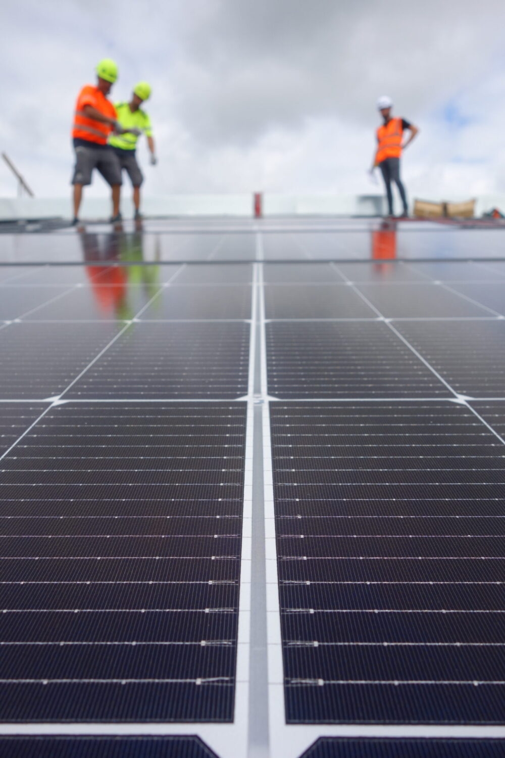
“Pour devenir une entreprise à énergie positive, Vergnaud acteur local nous a accompagnés dès le départ. Pour le technique: ils ont conçu toute l’installation, et se sont occupés de toute la partie administrative, ce qui a été une grande chance vu que nous ne sommes pas spécialistes”
Pierre Couture
Dirigeant, Établissements Couture à Biron (64)
 Accompagnement personnalisé
Un interlocuteur dédié qui vous suit du premier rendez-vous à la maintenance, pour un projet clair et sans surprise.
 Performance et rentabilité
Des centrales solaires conçues pour délivrer des rendements mesurés, suivis et sécurisés sur le long terme.
 Maîtrise technique
Toutes les compétences intégrées en interne (études, conception, pose, maintenance), pour garantir la fiabilité totale de vos projets.
 Ancrage territorial
Entreprise familiale de plus de 50 collaborateurs, ancrée dans le Sud-Ouest, nous accompagnons au quotidien les enjeux agricoles, industriels, fonciers et écologiques de notre territoire.
Chez Vergnaud, plus de 50 collaborateurs partagent une ambition commune : construire le futur énergétique des acteurs du Sud-Ouest.
Ici, chacun évolue dans un environnement technique exigeant, à taille humaine, où l’innovation et l’amélioration continue sont au coeur de nos métiers.
Rejoindre Vergnaud, c’est participer à un projet collectif fort, qui allie expertise, ancrage territorial et impact environnemental.
Voir nos offres
Parce que le solaire évolue vite, nous partageons nos projets, nos innovations et nos prises de parole pour accompagner la transition énergétique.
Découvrez nos dernières actualités photovoltaïques et suivez les chantiers Vergnaud au plus près.
Découverte d’un projet de 226 kWc combinant un bâtiment industriel et une ombrière photovoltaïque.
Lire la suiteNos équipes ont récemment finalisé une centrale photovoltaïque de 335 kWc sur ce site industriel.
Lire la suiteChaque année, toutes les équipes se retrouvent pour une journée placée sous le signe de la cohésion et du partage.
Lire la suiteNous lançons la toute première édition de notre journal dédié au photovoltaïque, à l’innovation et à l’autonomie énergétique.
Lire la suiteNous vous accompagnons pour transformer votre énergie en une ressource et un levier de croissance.
Prenons RDV